Fayette elevation
Fayette (Alabama, Fayette County), United States elevation is 111 meters and Fayette elevation in feet is 364 ft above sea level [src 1]. Fayette is a seat of a second-order administrative division (feature code) with elevation that is 168 meters (551 ft) smaller than average city elevation in United States.
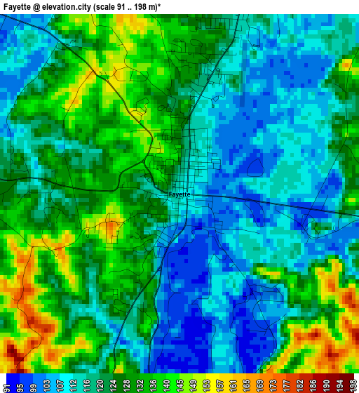
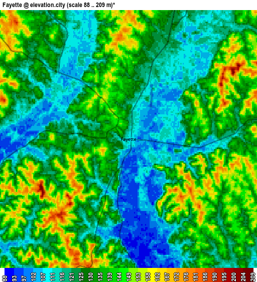
Below is the Elevation map of Fayette, which displays elevation range with different colors. Scale of the first map is from 91 to 198 m (299 to 650 ft) with average elevation of 122.7 meters (=403 ft) [note 1]
These maps also provides idea of topography and contour of this city, they are displayed at different zoom levels. More info about maps, scale and edge coordinates you can find below images.
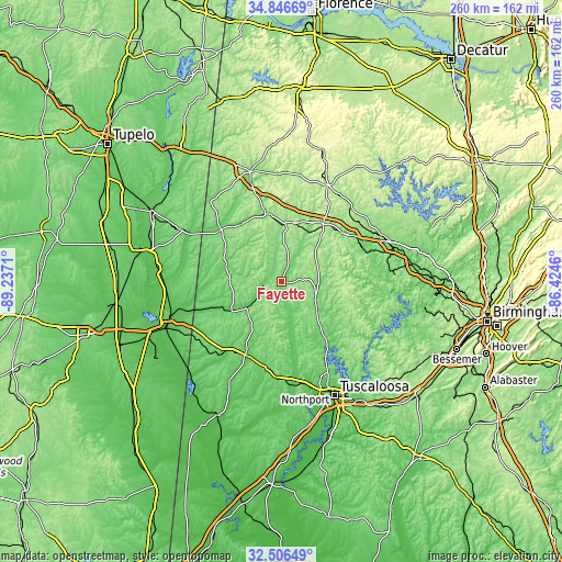
| \ | Map #1 | Map #2 | Topo.Map |
| Scale [m] | 91..198 m | 88..209 m | × |
| Scale [ft] | 299..650 ft | 289..686 ft | × |
| Average | 122.7 m = 403 ft | 129.4 m = 425 ft | × |
| Width | 8.13 km = 5.1 mi | 16.26 km = 10.1 mi | 260.2 km = 161.7 mi |
| Height | 8.13 km = 5.1 mi | 16.26 km = 10.1 mi | 260.2 km = 161.7 mi |
| ↑Max Latitude | 33.721109° | 33.757653° | 34.84669° |
| Latitude at center | 33.68455° | 33.68455° | 33.68455° |
| ↓Min Latitude | 33.647975° | 33.611385° | 32.50649° |
| ← Min Longitude | -87.874795° | -87.918741° | -89.2371° |
| Longitude center | -87.83085° | -87.83085° | -87.83085° |
| →Max Longitude | -87.786905° | -87.742959° | -86.4246° |
Nearby cities:
Cities around Fayette sort by population:
• Hamilton elevation 152 m
52.9 km,  344°
344°
• Winfield 145 m
27.2 km,  2°
2°
• New Hope 79 m
51.9 km,  242°
242°
• Guin 137 m
32.2 km,  346°
346°
• Carbon Hill 147 m
36.4 km,  50°
50°
• Vernon 91 m
27 km,  287°
287°
• Sulligent 100 m
37 km,  310°
310°
• Gordo 85 m
41.1 km,  189°
189°
• Reform 73 m
38.1 km,  206°
206°
• Berry 140 m
21.5 km,  97°
97°
• Caledonia 102 m
45.7 km,  269°
269°
• Carrollton 75 m
53 km, 207°
Multilingual:
 En español:
Fayette elevación 111 m.
 En France:
Fayette élévation 111 m.


Sources and notes:
- [note 1] Map square and city borders are not equal. Map elevation data is calculated only from area inside that square.
- [src 1] Elevation data from geonames database provided with same terms of usage.
- [src 2] The elevation map of Fayette is generated using elevation data from NASA's 3 arcsec (90m) resolution SRTM data.
- [src 3] Base (background) map © OpenStreetMap contributors tiles are generated by Geofabrik and OpenTopoMap.
Copyright & License:
This Fayette Elevation Map is licensed under CC BY-SA. You may reuse any part from this page, if you give a proper credit by linking to this URL:
 More info on terms of use page.