Carrollton elevation
Carrollton (Alabama, Pickens County), United States elevation is 75 meters and Carrollton elevation in feet is 246 ft above sea level [src 1]. Carrollton is a seat of a second-order administrative division (feature code) with elevation that is 204 meters (669 ft) smaller than average city elevation in United States.
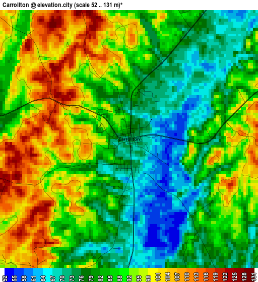
Below is the Elevation map of Carrollton, which displays elevation range with different colors. Scale of the first map is from 52 to 131 m (171 to 430 ft) with average elevation of 87.2 meters (=286 ft) [note 1]
These maps also provides idea of topography and contour of this city, they are displayed at different zoom levels. More info about maps, scale and edge coordinates you can find below images.
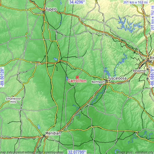
| \ | Map #1 | Topo.Map |
| Scale [m] | 52..131 m | × |
| Scale [ft] | 171..430 ft | × |
| Average | 87.2 m = 286 ft | × |
| Width | 8.17 km = 5.1 mi | 261.5 km = 162.5 mi |
| Height | 8.17 km = 5.1 mi | 261.5 km = 162.5 mi |
| ↑Max Latitude | 33.298428° | 34.4296° |
| Latitude at center | 33.26169° | 33.26169° |
| ↓Min Latitude | 33.224936° | 32.07795° |
| ← Min Longitude | -88.138975° | -89.50128° |
| Longitude center | -88.09503° | -88.09503° |
| →Max Longitude | -88.051085° | -86.68878° |
Nearby cities:
Cities around Carrollton sort by population:
• Tuscaloosa elevation 69 m
49.2 km,  96°
96°
• Northport 69 m
48.3 km,  94°
94°
• Columbus 69 m
40.4 km,  310°
310°
• New Hope 79 m
31.5 km,  316°
316°
• Eutaw 69 m
50.7 km,  157°
157°
• Macon 60 m
46.7 km,  248°
248°
• Moundville 52 m
52.3 km,  124°
124°
• Aliceville 61 m
15.6 km,  199°
199°
• Gordo 85 m
19 km,  70°
70°
• Reform 73 m
14.9 km,  29°
29°
• Brooksville 86 m
45.4 km,  266°
266°
• Caledonia 102 m
51.4 km,  335°
335°
Multilingual:
 En español:
Carrollton elevación 75 m.
 En France:
Carrollton élévation 75 m.
 Auf Deutsch:
Carrollton höhe über dem Meeresspiegel ist 75 m.

Sources and notes:
- [note 1] Map square and city borders are not equal. Map elevation data is calculated only from area inside that square.
- [src 1] Elevation data from geonames database provided with same terms of usage.
- [src 2] The elevation map of Carrollton is generated using elevation data from NASA's 3 arcsec (90m) resolution SRTM data.
- [src 3] Base (background) map © OpenStreetMap contributors tiles are generated by Geofabrik and OpenTopoMap.
Copyright & License:
This Carrollton Elevation Map is licensed under CC BY-SA. You may reuse any part from this page, if you give a proper credit by linking to this URL:
 More info on terms of use page.