Dadeville elevation
Dadeville (Alabama, Tallapoosa County), United States elevation is 224 meters and Dadeville elevation in feet is 735 ft above sea level [src 1]. Dadeville is a seat of a second-order administrative division (feature code) with elevation that is 55 meters (180 ft) smaller than average city elevation in United States.
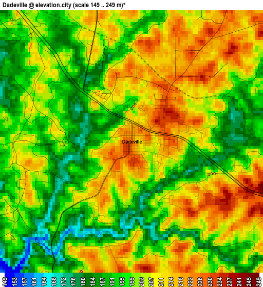
Below is the Elevation map of Dadeville, which displays elevation range with different colors. Scale of the first map is from 149 to 249 m (489 to 817 ft) with average elevation of 202.6 meters (=665 ft) [note 1]
These maps also provides idea of topography and contour of this city, they are displayed at different zoom levels. More info about maps, scale and edge coordinates you can find below images.
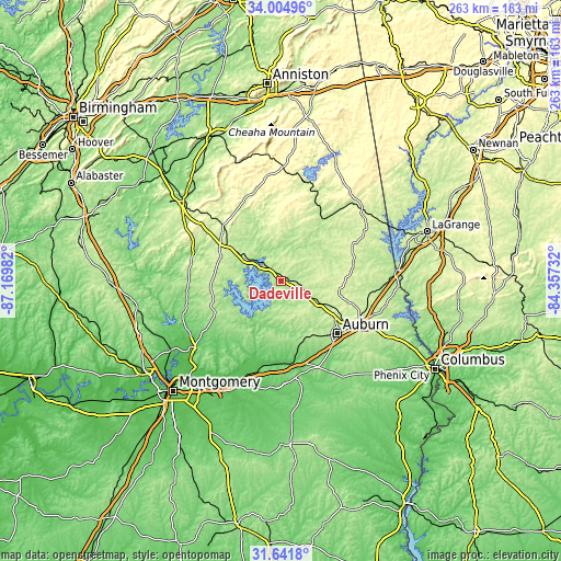
| \ | Map #1 | Topo.Map |
| Scale [m] | 149..249 m | × |
| Scale [ft] | 489..817 ft | × |
| Average | 202.6 m = 665 ft | × |
| Width | 8.21 km = 5.1 mi | 262.8 km = 163.3 mi |
| Height | 8.21 km = 5.1 mi | 262.8 km = 163.3 mi |
| ↑Max Latitude | 32.868158° | 34.00496° |
| Latitude at center | 32.83124° | 32.83124° |
| ↓Min Latitude | 32.794306° | 31.6418° |
| ← Min Longitude | -85.807515° | -87.16982° |
| Longitude center | -85.76357° | -85.76357° |
| →Max Longitude | -85.719625° | -84.35732° |
Nearby cities:
Cities around Dadeville sort by population:
• Auburn elevation 220 m
36.1 km,  132°
132°
• Opelika 254 m
41.5 km,  119°
119°
• Alexander City 217 m
21.7 km,  305°
305°
• Tuskegee 147 m
45.8 km,  171°
171°
• Roanoke 258 m
51 km,  45°
45°
• Tallassee 123 m
35 km,  200°
200°
• Lafayette 264 m
34.7 km,  77°
77°
• Huguley 216 m
49.9 km,  89°
89°
• Ashland 343 m
49.7 km,  352°
352°
• Goodwater 264 m
37.6 km, 313°
• Eclectic 179 m
33.4 km,  229°
229°
• Rockford 224 m
43.1 km,  278°
278°
Multilingual:
 En español:
Dadeville elevación 224 m.
 En France:
Dadeville élévation 224 m.
 Auf Deutsch:
Dadeville höhe über dem Meeresspiegel ist 224 m.

Sources and notes:
- [note 1] Map square and city borders are not equal. Map elevation data is calculated only from area inside that square.
- [src 1] Elevation data from geonames database provided with same terms of usage.
- [src 2] The elevation map of Dadeville is generated using elevation data from NASA's 3 arcsec (90m) resolution SRTM data.
- [src 3] Base (background) map © OpenStreetMap contributors tiles are generated by Geofabrik and OpenTopoMap.
Copyright & License:
This Dadeville Elevation Map is licensed under CC BY-SA. You may reuse any part from this page, if you give a proper credit by linking to this URL:
 More info on terms of use page.