Ashland elevation
Ashland (Alabama, Clay County), United States elevation is 343 meters and Ashland elevation in feet is 1125 ft above sea level [src 1]. Ashland is a seat of a second-order administrative division (feature code) with elevation that is 64 meters (210 ft) bigger than average city elevation in United States.
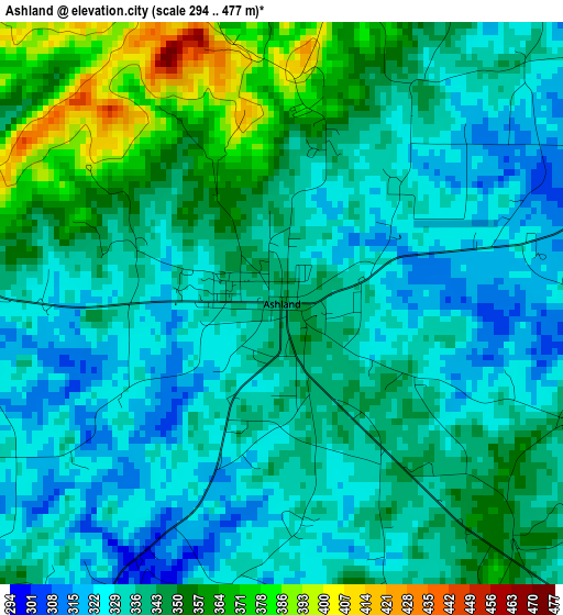
Below is the Elevation map of Ashland, which displays elevation range with different colors. Scale of the first map is from 294 to 477 m (965 to 1565 ft) with average elevation of 340.5 meters (=1117 ft) [note 1]
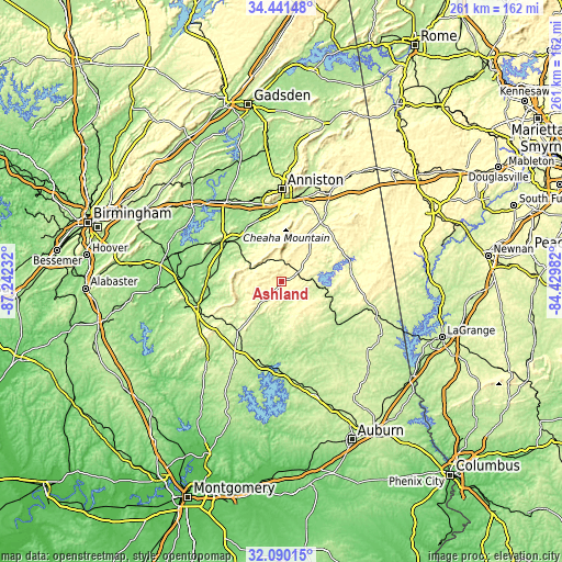
These maps also provides idea of topography and contour of this city, they are displayed at different zoom levels. More info about maps, scale and edge coordinates you can find below images.
| \ | Map #1 | Topo.Map |
| Scale [m] | 294..477 m | × |
| Scale [ft] | 965..1565 ft | × |
| Average | 340.5 m = 1117 ft | × |
| Width | 8.17 km = 5.1 mi | 261.4 km = 162.4 mi |
| Height | 8.17 km = 5.1 mi | 261.4 km = 162.4 mi |
| ↑Max Latitude | 33.310463° | 34.44148° |
| Latitude at center | 33.27373° | 33.27373° |
| ↓Min Latitude | 33.236981° | 32.09015° |
| ← Min Longitude | -85.880015° | -87.24232° |
| Longitude center | -85.83607° | -85.83607° |
| →Max Longitude | -85.792125° | -84.42982° |
Nearby cities:
Cities around Ashland sort by population:
• Anniston elevation 215 m
42.9 km,  0°
0°
• Oxford 201 m
37.9 km, 0°
• Talladega 170 m
30.9 km,  305°
305°
• Alexander City 217 m
38.3 km,  196°
196°
• Sylacauga 169 m
40.2 km,  253°
253°
• West End-Cobb Town 228 m
42.3 km,  355°
355°
• Lineville 325 m
8.6 km,  61°
61°
• Bynum 189 m
39.5 km,  342°
342°
• Goodwater 264 m
30.7 km,  221°
221°
• Mignon 164 m
40.8 km,  255°
255°
• Munford 191 m
30.4 km, 339°
• Wedowee 261 m
32.9 km,  83°
83°
Multilingual:
 En español:
Ashland elevación 343 m.
 En France:
Ashland élévation 343 m.


Sources and notes:
- [note 1] Map square and city borders are not equal. Map elevation data is calculated only from area inside that square.
- [src 1] Elevation data from geonames database provided with same terms of usage.
- [src 2] The elevation map of Ashland is generated using elevation data from NASA's 3 arcsec (90m) resolution SRTM data.
- [src 3] Base (background) map © OpenStreetMap contributors tiles are generated by Geofabrik and OpenTopoMap.
Copyright & License:
This Ashland Elevation Map is licensed under CC BY-SA. You may reuse any part from this page, if you give a proper credit by linking to this URL:
 More info on terms of use page.