Antratsyt elevation
Antratsyt (Luhansk), Ukraine elevation is 235 meters and Antratsyt elevation in feet is 771 ft above sea level [src 1]. Antratsyt is a seat of a second-order administrative division (feature code) with elevation that is 78 meters (256 ft) bigger than average city elevation in Ukraine.
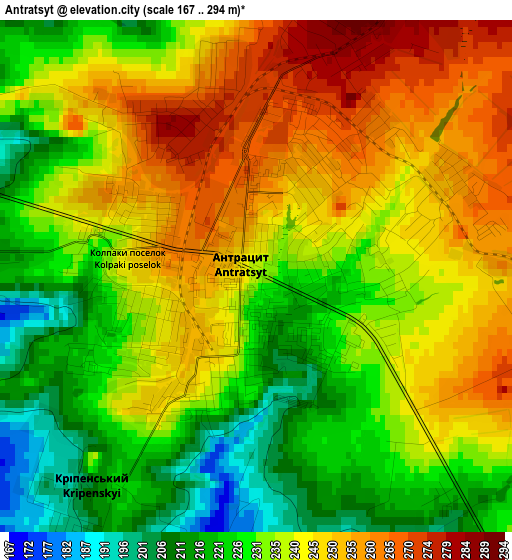
Below is the Elevation map of Antratsyt, which displays elevation range with different colors. Scale of the first map is from 167 to 294 m (548 to 965 ft) with average elevation of 237.1 meters (=778 ft) [note 1]
These maps also provides idea of topography and contour of this city, they are displayed at different zoom levels. More info about maps, scale and edge coordinates you can find below images.
| \ | Map #1 | Map #2 | Topo.Map |
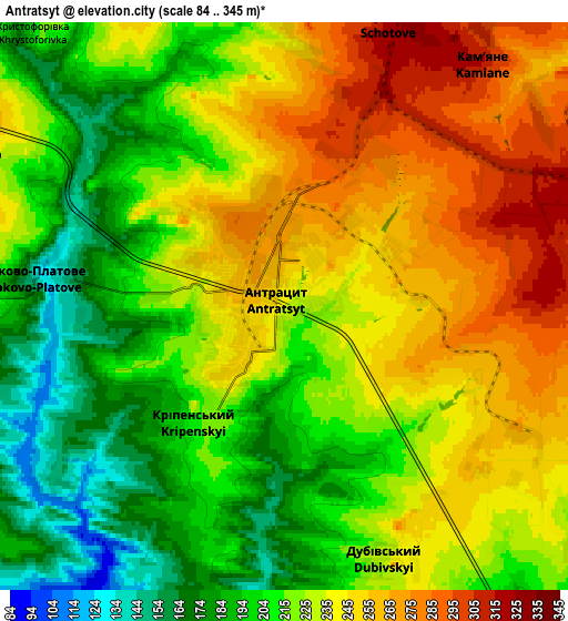
| Scale [m] | 167..294 m | 84..345 m | × |
| Scale [ft] | 548..965 ft | 276..1132 ft | × |
| Average | 237.1 m = 778 ft | 226 m = 741 ft | × |
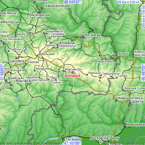
| Width | 6.52 km = 4.1 mi | 13.05 km = 8.1 mi | 208.8 km = 129.7 mi |
| Height | 6.52 km = 4.1 mi | 13.05 km = 8.1 mi | 208.8 km = 129.7 mi |
| ↑Max Latitude | 48.144361° | 48.173676° | 49.04533° |
| Latitude at center | 48.11503° | 48.11503° | 48.11503° |
| ↓Min Latitude | 48.085682° | 48.056317° | 47.16758° |
| ← Min Longitude | 39.047335° | 39.003389° | 37.68503° |
| Longitude center | 39.09128° | 39.09128° | 39.09128° |
| →Max Longitude | 39.135225° | 39.179171° | 40.49753° |
Nearby cities:
Cities around Antratsyt sort by population:
• Krasnyy Luch elevation 266 m
11.8 km,  283°
283°
• Snizhne 290 m
25.7 km,  247°
247°
• Roven’ky 265 m
21.6 km,  99°
99°
• Lutuhyne 119 m
33.8 km,  17°
17°
• Uspenka 93 m
31.1 km,  9°
9°
• Kripens’kyy 189 m
4.9 km,  210°
210°
• Miusyns’k 97 m
14.5 km, 253°
• Dmytrivka 51 m
23 km, 210°
• Millerovo 282 m
8.1 km,  42°
42°
• Krasnyy Kut 155 m
23.8 km,  293°
293°
• Zalesnoye 275 m
22.9 km, 245°
• Klenovyy 284 m
27.3 km,  88°
88°
Multilingual:
 En español:
Antratsyt elevación 235 m.
 En France:
Antratsyt élévation 235 m.
 Auf Deutsch:
Antrazyt höhe über dem Meeresspiegel ist 235 m.

Sources and notes:
- [note 1] Map square and city borders are not equal. Map elevation data is calculated only from area inside that square.
- [src 1] Elevation data from geonames database provided with same terms of usage.
- [src 2] The elevation map of Antratsyt is generated using elevation data from NASA's 3 arcsec (90m) resolution SRTM data.
- [src 3] Base (background) map © OpenStreetMap contributors tiles are generated by Geofabrik and OpenTopoMap.
Copyright & License:
This Antratsyt Elevation Map is licensed under CC BY-SA. You may reuse any part from this page, if you give a proper credit by linking to this URL:
 More info on terms of use page.