Lutuhyne elevation
Lutuhyne (Luhansk), Ukraine elevation is 119 meters and Lutuhyne elevation in feet is 390 ft above sea level [src 1]. Lutuhyne is a seat of a second-order administrative division (feature code) with elevation that is 38 meters (125 ft) smaller than average city elevation in Ukraine.
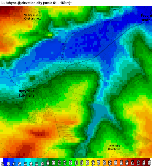
Below is the Elevation map of Lutuhyne, which displays elevation range with different colors. Scale of the first map is from 61 to 189 m (200 to 620 ft) with average elevation of 109.4 meters (=359 ft) [note 1]
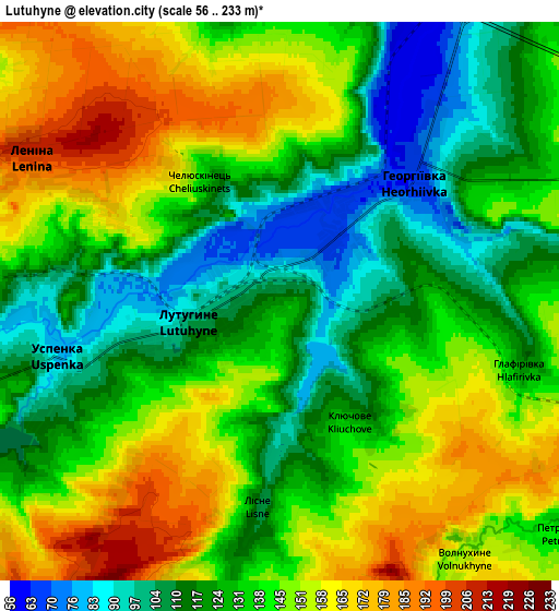
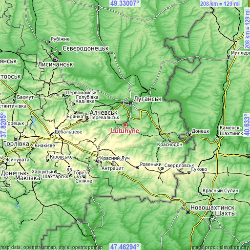
These maps also provides idea of topography and contour of this city, they are displayed at different zoom levels. More info about maps, scale and edge coordinates you can find below images.
| \ | Map #1 | Map #2 | Topo.Map |
| Scale [m] | 61..189 m | 56..233 m | × |
| Scale [ft] | 200..620 ft | 184..764 ft | × |
| Average | 109.4 m = 359 ft | 136.3 m = 447 ft | × |
| Width | 6.49 km = 4 mi | 12.98 km = 8.1 mi | 207.6 km = 129 mi |
| Height | 6.49 km = 4 mi | 12.98 km = 8.1 mi | 207.6 km = 129 mi |
| ↑Max Latitude | 48.434235° | 48.463384° | 49.33007° |
| Latitude at center | 48.40507° | 48.40507° | 48.40507° |
| ↓Min Latitude | 48.375888° | 48.346689° | 47.46294° |
| ← Min Longitude | 39.182805° | 39.138859° | 37.8205° |
| Longitude center | 39.22675° | 39.22675° | 39.22675° |
| →Max Longitude | 39.270695° | 39.314641° | 40.633° |
Nearby cities:
Cities around Lutuhyne sort by population:
• Luhansk elevation 103 m
19.2 km,  20°
20°
• Alchevs’k 211 m
31.1 km,  283°
283°
• Pereval’s’k 227 m
28.5 km, 277°
• Zymohiria 53 m
29.3 km,  313°
313°
• Uspenka 93 m
5 km,  251°
251°
• Bile 68 m
16.4 km, 307°
• Rozkishne 55 m
10.2 km, 22°
• Teple 184 m
26.9 km,  112°
112°
• Millerovo 282 m
26.7 km,  189°
189°
• Simeykyne 199 m
24.3 km, 111°
• Lenina 182 m
6.6 km,  294°
294°
• Buran 172 m
31 km, 112°
Multilingual:
 En español:
Lutúgine elevación 119 m.
 En France:
Loutouhyne élévation 119 m.
 Auf Deutsch:
Lutuhyne höhe über dem Meeresspiegel ist 119 m.

Sources and notes:
- [note 1] Map square and city borders are not equal. Map elevation data is calculated only from area inside that square.
- [src 1] Elevation data from geonames database provided with same terms of usage.
- [src 2] The elevation map of Lutuhyne is generated using elevation data from NASA's 3 arcsec (90m) resolution SRTM data.
- [src 3] Base (background) map © OpenStreetMap contributors tiles are generated by Geofabrik and OpenTopoMap.
Copyright & License:
This Lutuhyne Elevation Map is licensed under CC BY-SA. You may reuse any part from this page, if you give a proper credit by linking to this URL:
 More info on terms of use page.