Roven’ky elevation
Roven’ky (Luhansk), Ukraine elevation is 265 meters and Roven’ky elevation in feet is 869 ft above sea level [src 1]. Roven’ky is a populated place (feature code) with elevation that is 108 meters (354 ft) bigger than average city elevation in Ukraine.
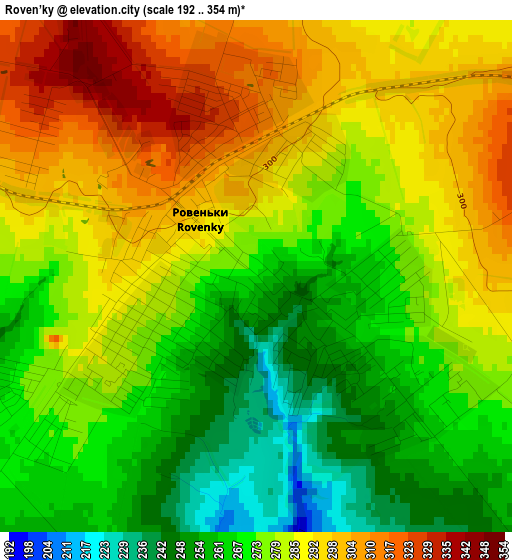
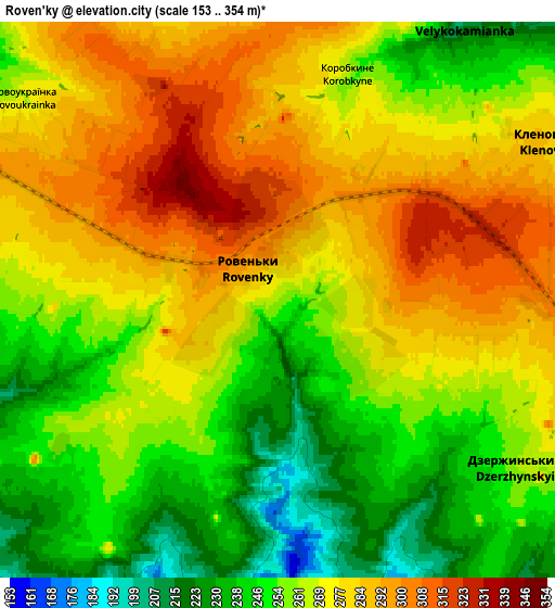
Below is the Elevation map of Roven’ky, which displays elevation range with different colors. Scale of the first map is from 192 to 354 m (630 to 1161 ft) with average elevation of 279.5 meters (=917 ft) [note 1]
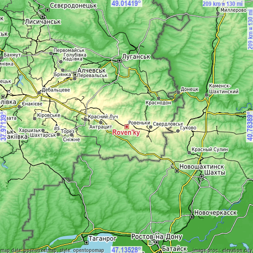
These maps also provides idea of topography and contour of this city, they are displayed at different zoom levels. More info about maps, scale and edge coordinates you can find below images.
| \ | Map #1 | Map #2 | Topo.Map |
| Scale [m] | 192..354 m | 153..354 m | × |
| Scale [ft] | 630..1161 ft | 502..1161 ft | × |
| Average | 279.5 m = 917 ft | 266.8 m = 875 ft | × |
| Width | 6.53 km = 4.1 mi | 13.06 km = 8.1 mi | 208.9 km = 129.8 mi |
| Height | 6.53 km = 4.1 mi | 13.06 km = 8.1 mi | 208.9 km = 129.8 mi |
| ↑Max Latitude | 48.112659° | 48.141992° | 49.01419° |
| Latitude at center | 48.08331° | 48.08331° | 48.08331° |
| ↓Min Latitude | 48.053944° | 48.024561° | 47.13528° |
| ← Min Longitude | 39.333695° | 39.289749° | 37.97139° |
| Longitude center | 39.37764° | 39.37764° | 39.37764° |
| →Max Longitude | 39.421585° | 39.465531° | 40.78389° |
Nearby cities:
Cities around Roven’ky sort by population:
• Krasnyy Luch elevation 266 m
33.3 km,  280°
280°
• Sverdlovs’k 271 m
20.4 km,  88°
88°
• Antratsyt 235 m
21.6 km, 279°
• Chervonopartyzans’k 301 m
31.1 km, 91°
• Kripens’kyy 189 m
23.8 km,  268°
268°
• Miusyns’k 97 m
35.2 km, 268°
• Teple 184 m
28.9 km,  28°
28°
• Biryukove 204 m
30.3 km,  117°
117°
• Millerovo 282 m
18.4 km,  300°
300°
• Simeykyne 199 m
29.4 km,  23°
23°
• Klenovyy 284 m
7.2 km,  56°
56°
• Buran 172 m
29.8 km,  36°
36°
Multilingual:
 En español:
Roven’ky elevación 265 m.
 En France:
Roven’ky élévation 265 m.
 Auf Deutsch:
Roven’ky höhe über dem Meeresspiegel ist 265 m.

Sources and notes:
- [note 1] Map square and city borders are not equal. Map elevation data is calculated only from area inside that square.
- [src 1] Elevation data from geonames database provided with same terms of usage.
- [src 2] The elevation map of Roven’ky is generated using elevation data from NASA's 3 arcsec (90m) resolution SRTM data.
- [src 3] Base (background) map © OpenStreetMap contributors tiles are generated by Geofabrik and OpenTopoMap.
Copyright & License:
This Roven’ky Elevation Map is licensed under CC BY-SA. You may reuse any part from this page, if you give a proper credit by linking to this URL:
 More info on terms of use page.