Sverdlovs’k elevation
Sverdlovs’k (Luhansk, Syevyerodonets’ka Mis’krada), Ukraine elevation is 271 meters and Sverdlovs’k elevation in feet is 889 ft above sea level [src 1]. Sverdlovs’k is a seat of a second-order administrative division (feature code) with elevation that is 114 meters (374 ft) bigger than average city elevation in Ukraine.
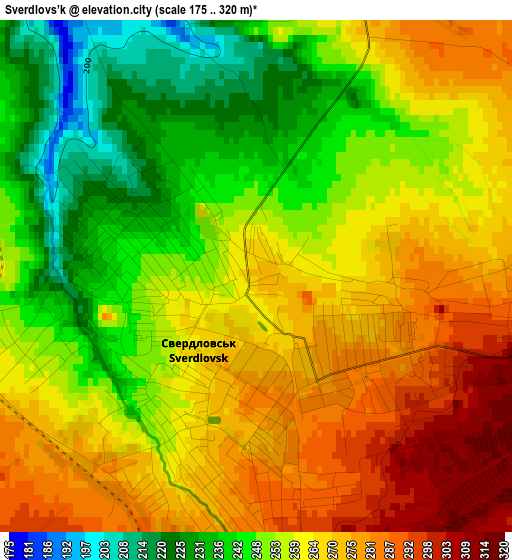
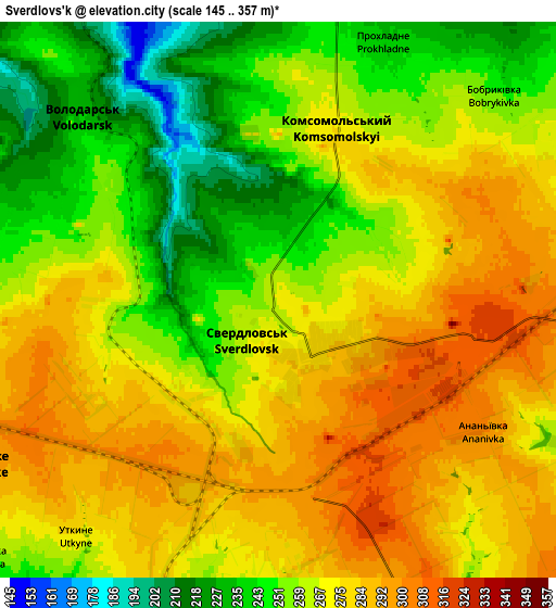
Below is the Elevation map of Sverdlovs’k, which displays elevation range with different colors. Scale of the first map is from 175 to 320 m (574 to 1050 ft) with average elevation of 259.2 meters (=850 ft) [note 1]
These maps also provides idea of topography and contour of this city, they are displayed at different zoom levels. More info about maps, scale and edge coordinates you can find below images.
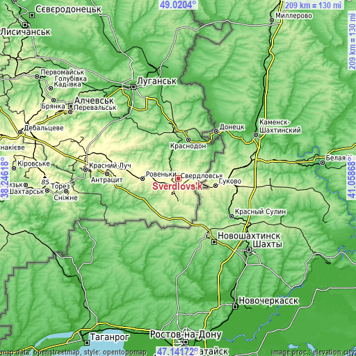
| \ | Map #1 | Map #2 | Topo.Map |
| Scale [m] | 175..320 m | 145..357 m | × |
| Scale [ft] | 574..1050 ft | 476..1171 ft | × |
| Average | 259.2 m = 850 ft | 266.6 m = 875 ft | × |
| Width | 6.53 km = 4.1 mi | 13.06 km = 8.1 mi | 208.9 km = 129.8 mi |
| Height | 6.53 km = 4.1 mi | 13.06 km = 8.1 mi | 208.9 km = 129.8 mi |
| ↑Max Latitude | 48.118986° | 48.148315° | 49.0204° |
| Latitude at center | 48.08964° | 48.08964° | 48.08964° |
| ↓Min Latitude | 48.060278° | 48.030898° | 47.14172° |
| ← Min Longitude | 39.608485° | 39.564539° | 38.24618° |
| Longitude center | 39.65243° | 39.65243° | 39.65243° |
| →Max Longitude | 39.696375° | 39.740321° | 41.05868° |
Nearby cities:
Cities around Sverdlovs’k sort by population:
• Antratsyt elevation 235 m
41.8 km,  273°
273°
• Roven’ky 265 m
20.4 km, 268°
• Sorokyne 143 m
23.4 km,  15°
15°
• Molodohvardiys’k 215 m
28.4 km,  0°
0°
• Chervonopartyzans’k 301 m
10.8 km,  98°
98°
• Teple 184 m
25.6 km,  344°
344°
• Biryukove 204 m
16.1 km,  156°
156°
• Millerovo 282 m
37.2 km,  283°
283°
• Uralo-Kavkaz 109 m
28.1 km, 23°
• Simeykyne 199 m
27.8 km, 341°
• Klenovyy 284 m
14.8 km, 282°
• Buran 172 m
23.6 km,  353°
353°
Multilingual:
 En español:
Sverdlovs’k elevación 271 m.
 En France:
Sverdlovs’k élévation 271 m.
 Auf Deutsch:
Sverdlovs’k höhe über dem Meeresspiegel ist 271 m.

Sources and notes:
- [note 1] Map square and city borders are not equal. Map elevation data is calculated only from area inside that square.
- [src 1] Elevation data from geonames database provided with same terms of usage.
- [src 2] The elevation map of Sverdlovs’k is generated using elevation data from NASA's 3 arcsec (90m) resolution SRTM data.
- [src 3] Base (background) map © OpenStreetMap contributors tiles are generated by Geofabrik and OpenTopoMap.
Copyright & License:
This Sverdlovs’k Elevation Map is licensed under CC BY-SA. You may reuse any part from this page, if you give a proper credit by linking to this URL:
 More info on terms of use page.