Belaya elevation
Belaya (Ternopil), Ukraine elevation is 277 meters and Belaya elevation in feet is 909 ft above sea level [src 1]. Belaya is a populated place (feature code) with elevation that is 120 meters (394 ft) bigger than average city elevation in Ukraine.
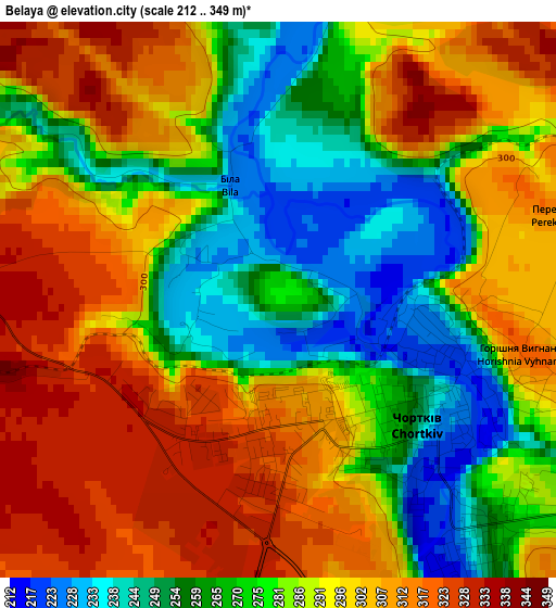
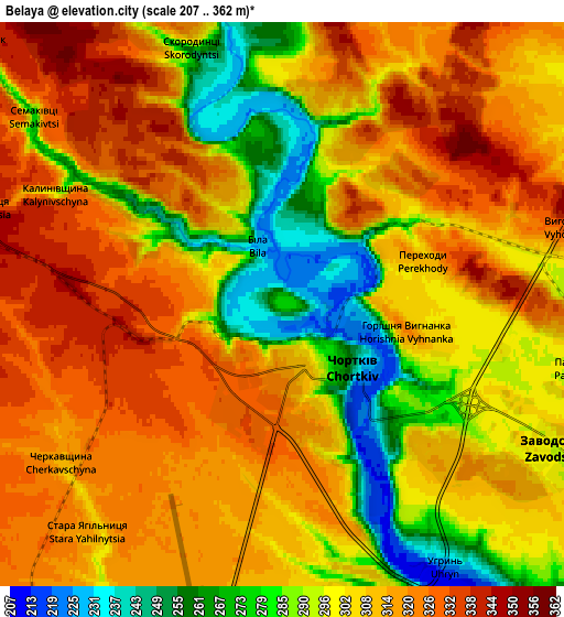
Below is the Elevation map of Belaya, which displays elevation range with different colors. Scale of the first map is from 212 to 349 m (696 to 1145 ft) with average elevation of 286.1 meters (=939 ft) [note 1]
These maps also provides idea of topography and contour of this city, they are displayed at different zoom levels. More info about maps, scale and edge coordinates you can find below images.
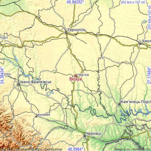
| \ | Map #1 | Map #2 | Topo.Map |
| Scale [m] | 212..349 m | 207..362 m | × |
| Scale [ft] | 696..1145 ft | 679..1188 ft | × |
| Average | 286.1 m = 939 ft | 305.6 m = 1003 ft | × |
| Width | 6.41 km = 4 mi | 12.82 km = 8 mi | 205 km = 127.4 mi |
| Height | 6.41 km = 4 mi | 12.82 km = 8 mi | 205 km = 127.4 mi |
| ↑Max Latitude | 49.057806° | 49.086594° | 49.94252° |
| Latitude at center | 49.029° | 49.029° | 49.029° |
| ↓Min Latitude | 49.000178° | 48.971339° | 48.0984° |
| ← Min Longitude | 25.726645° | 25.682699° | 24.36434° |
| Longitude center | 25.77059° | 25.77059° | 25.77059° |
| →Max Longitude | 25.814535° | 25.858481° | 27.17684° |
Nearby cities:
Cities around Belaya sort by population:
• Chortkiv elevation 227 m
2.4 km,  123°
123°
• Terebovlya 350 m
30.7 km,  351°
351°
• Buchach 326 m
28.1 km,  277°
277°
• Borshchiv 253 m
32.1 km,  141°
141°
• Husiatyn 277 m
30.6 km,  80°
80°
• Khorostkiv 306 m
23 km,  28°
28°
• Kopychyntsi 309 m
13.2 km,  50°
50°
• Tovste 282 m
20.5 km,  189°
189°
• Druzhba 332 m
23.4 km,  273°
273°
• Yahil’nytsya 297 m
9.8 km, 191°
• Husiatyn 268 m
33.3 km, 82°
• Nyrkiv 330 m
26.9 km,  207°
207°
Multilingual:
 En español:
Belaya elevación 277 m.
 En France:
Belaya élévation 277 m.


Sources and notes:
- [note 1] Map square and city borders are not equal. Map elevation data is calculated only from area inside that square.
- [src 1] Elevation data from geonames database provided with same terms of usage.
- [src 2] The elevation map of Belaya is generated using elevation data from NASA's 3 arcsec (90m) resolution SRTM data.
- [src 3] Base (background) map © OpenStreetMap contributors tiles are generated by Geofabrik and OpenTopoMap.
Copyright & License:
This Belaya Elevation Map is licensed under CC BY-SA. You may reuse any part from this page, if you give a proper credit by linking to this URL:
 More info on terms of use page.