Khorostkiv elevation
Khorostkiv (Ternopil), Ukraine elevation is 306 meters and Khorostkiv elevation in feet is 1004 ft above sea level [src 1]. Khorostkiv is a populated place (feature code) with elevation that is 149 meters (489 ft) bigger than average city elevation in Ukraine.
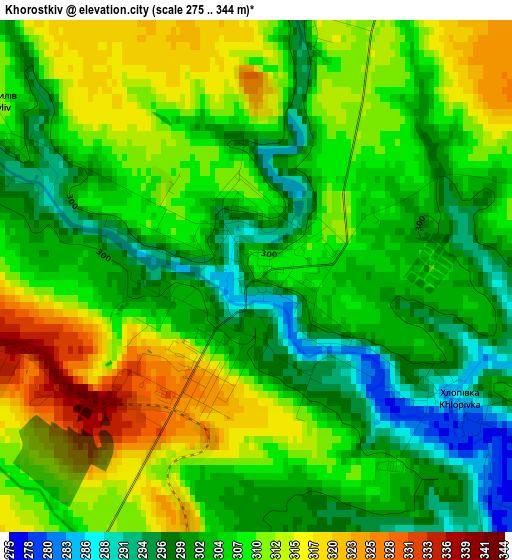
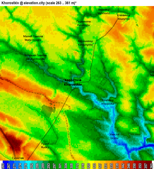
Below is the Elevation map of Khorostkiv, which displays elevation range with different colors. Scale of the first map is from 275 to 344 m (902 to 1129 ft) with average elevation of 306.9 meters (=1007 ft) [note 1]
These maps also provides idea of topography and contour of this city, they are displayed at different zoom levels. More info about maps, scale and edge coordinates you can find below images.
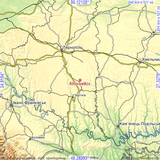
| \ | Map #1 | Map #2 | Topo.Map |
| Scale [m] | 275..344 m | 263..361 m | × |
| Scale [ft] | 902..1129 ft | 863..1184 ft | × |
| Average | 306.9 m = 1007 ft | 311.9 m = 1023 ft | × |
| Width | 6.38 km = 4 mi | 12.77 km = 7.9 mi | 204.3 km = 126.9 mi |
| Height | 6.38 km = 4 mi | 12.77 km = 7.9 mi | 204.3 km = 126.9 mi |
| ↑Max Latitude | 49.23984° | 49.268523° | 50.12128° |
| Latitude at center | 49.21114° | 49.21114° | 49.21114° |
| ↓Min Latitude | 49.182423° | 49.15369° | 48.28393° |
| ← Min Longitude | 25.877705° | 25.833759° | 24.5154° |
| Longitude center | 25.92165° | 25.92165° | 25.92165° |
| →Max Longitude | 25.965595° | 26.009541° | 27.3279° |
Nearby cities:
Cities around Khorostkiv sort by population:
• Chortkiv elevation 227 m
23.4 km,  202°
202°
• Terebovlya 350 m
18.4 km,  303°
303°
• Husiatyn 277 m
24.5 km,  128°
128°
• Kopychyntsi 309 m
11.9 km,  183°
183°
• Skalat 320 m
24.4 km,  9°
9°
• Belaya 277 m
23 km,  208°
208°
• Mikulintsy 292 m
30.8 km,  311°
311°
• Velikiye Borki 325 m
36.7 km,  341°
341°
• Hrymayliv 308 m
14.9 km,  25°
25°
• Zakupne 322 m
31.9 km,  108°
108°
• Yahil’nytsya 297 m
32.6 km, 203°
• Husiatyn 268 m
26.9 km, 125°
Multilingual:
 En español:
Khorostkiv elevación 306 m.
 En France:
Khorostkiv élévation 306 m.
 Auf Deutsch:
Khorostkiv höhe über dem Meeresspiegel ist 306 m.

Sources and notes:
- [note 1] Map square and city borders are not equal. Map elevation data is calculated only from area inside that square.
- [src 1] Elevation data from geonames database provided with same terms of usage.
- [src 2] The elevation map of Khorostkiv is generated using elevation data from NASA's 3 arcsec (90m) resolution SRTM data.
- [src 3] Base (background) map © OpenStreetMap contributors tiles are generated by Geofabrik and OpenTopoMap.
Copyright & License:
This Khorostkiv Elevation Map is licensed under CC BY-SA. You may reuse any part from this page, if you give a proper credit by linking to this URL:
 More info on terms of use page.