Terebovlya elevation
Terebovlya (Ternopil), Ukraine elevation is 350 meters and Terebovlya elevation in feet is 1148 ft above sea level [src 1]. Terebovlya is a seat of a second-order administrative division (feature code) with elevation that is 193 meters (633 ft) bigger than average city elevation in Ukraine.
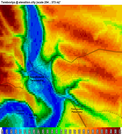
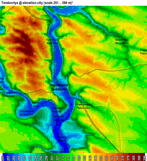
Below is the Elevation map of Terebovlya, which displays elevation range with different colors. Scale of the first map is from 254 to 373 m (833 to 1224 ft) with average elevation of 320 meters (=1050 ft) [note 1]
These maps also provides idea of topography and contour of this city, they are displayed at different zoom levels. More info about maps, scale and edge coordinates you can find below images.
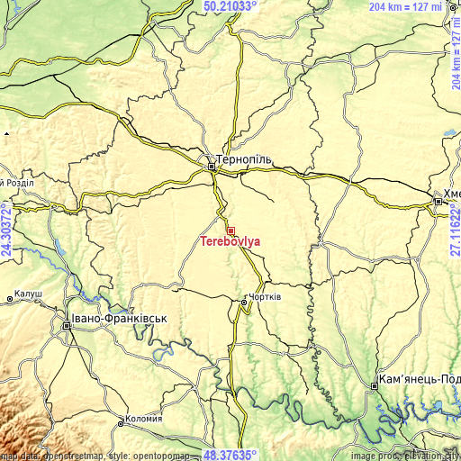
| \ | Map #1 | Map #2 | Topo.Map |
| Scale [m] | 254..373 m | 251..396 m | × |
| Scale [ft] | 833..1224 ft | 823..1299 ft | × |
| Average | 320 m = 1050 ft | 321.6 m = 1055 ft | × |
| Width | 6.37 km = 4 mi | 12.74 km = 7.9 mi | 203.9 km = 126.7 mi |
| Height | 6.37 km = 4 mi | 12.74 km = 7.9 mi | 203.9 km = 126.7 mi |
| ↑Max Latitude | 49.330517° | 49.359148° | 50.21033° |
| Latitude at center | 49.30187° | 49.30187° | 49.30187° |
| ↓Min Latitude | 49.273206° | 49.244526° | 48.37635° |
| ← Min Longitude | 25.666025° | 25.622079° | 24.30372° |
| Longitude center | 25.70997° | 25.70997° | 25.70997° |
| →Max Longitude | 25.753915° | 25.797861° | 27.11622° |
Nearby cities:
Cities around Terebovlya sort by population:
• Ternopil elevation 317 m
29.3 km,  342°
342°
• Chortkiv 227 m
32.3 km,  168°
168°
• Buchach 326 m
35.4 km,  221°
221°
• Khorostkiv 306 m
18.4 km,  123°
123°
• Kopychyntsi 309 m
26.3 km,  146°
146°
• Skalat 320 m
23.9 km,  54°
54°
• Belaya 277 m
30.7 km, 171°
• Mikulintsy 292 m
12.9 km,  324°
324°
• Velikiye Borki 325 m
24.9 km,  7°
7°
• Petrikov 320 m
27.2 km, 339°
• Hrymayliv 308 m
22.1 km,  81°
81°
• Druzhba 332 m
34.5 km,  213°
213°
Multilingual:
 En español:
Terebovlya elevación 350 m.
 En France:
Terebovlya élévation 350 m.
 Auf Deutsch:
Terebovlya höhe über dem Meeresspiegel ist 350 m.

Sources and notes:
- [note 1] Map square and city borders are not equal. Map elevation data is calculated only from area inside that square.
- [src 1] Elevation data from geonames database provided with same terms of usage.
- [src 2] The elevation map of Terebovlya is generated using elevation data from NASA's 3 arcsec (90m) resolution SRTM data.
- [src 3] Base (background) map © OpenStreetMap contributors tiles are generated by Geofabrik and OpenTopoMap.
Copyright & License:
This Terebovlya Elevation Map is licensed under CC BY-SA. You may reuse any part from this page, if you give a proper credit by linking to this URL:
 More info on terms of use page.