Nyrkiv elevation
Nyrkiv (Ternopil), Ukraine elevation is 330 meters and Nyrkiv elevation in feet is 1083 ft above sea level [src 1]. Nyrkiv is a populated place (feature code) with elevation that is 173 meters (568 ft) bigger than average city elevation in Ukraine.
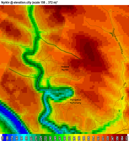
Below is the Elevation map of Nyrkiv, which displays elevation range with different colors. Scale of the first map is from 158 to 372 m (518 to 1220 ft) with average elevation of 308.6 meters (=1012 ft) [note 1]
These maps also provides idea of topography and contour of this city, they are displayed at different zoom levels. More info about maps, scale and edge coordinates you can find below images.
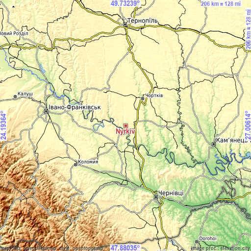
| \ | Map #1 | Topo.Map |
| Scale [m] | 158..372 m | × |
| Scale [ft] | 518..1220 ft | × |
| Average | 308.6 m = 1012 ft | × |
| Width | 6.44 km = 4 mi | 205.9 km = 127.9 mi |
| Height | 6.44 km = 4 mi | 205.9 km = 127.9 mi |
| ↑Max Latitude | 48.843849° | 49.73239° |
| Latitude at center | 48.81492° | 48.81492° |
| ↓Min Latitude | 48.785974° | 47.88035° |
| ← Min Longitude | 25.555945° | 24.19364° |
| Longitude center | 25.59989° | 25.59989° |
| →Max Longitude | 25.643835° | 27.00614° |
Nearby cities:
Cities around Nyrkiv sort by population:
• Chortkiv elevation 227 m
26.7 km,  32°
32°
• Zalishchyky 179 m
21.6 km,  152°
152°
• Horodenka 267 m
17.4 km,  204°
204°
• Belaya 277 m
26.9 km, 27°
• Tovste 282 m
9.9 km,  69°
69°
• Kadubivtsi 264 m
28.6 km, 154°
• Chernyatyn 295 m
20.5 km,  212°
212°
• Kostryzhivka 159 m
19.7 km,  155°
155°
• Zolotyy Potik 349 m
21.8 km,  298°
298°
• Chernelytsya 305 m
12.8 km,  268°
268°
• Druzhba 332 m
27.6 km,  336°
336°
• Yahil’nytsya 297 m
17.7 km,  36°
36°
Multilingual:
 En español:
Nyrkiv elevación 330 m.
 En France:
Nyrkiv élévation 330 m.


Sources and notes:
- [note 1] Map square and city borders are not equal. Map elevation data is calculated only from area inside that square.
- [src 1] Elevation data from geonames database provided with same terms of usage.
- [src 2] The elevation map of Nyrkiv is generated using elevation data from NASA's 3 arcsec (90m) resolution SRTM data.
- [src 3] Base (background) map © OpenStreetMap contributors tiles are generated by Geofabrik and OpenTopoMap.
Copyright & License:
This Nyrkiv Elevation Map is licensed under CC BY-SA. You may reuse any part from this page, if you give a proper credit by linking to this URL:
 More info on terms of use page.