Zalishchyky elevation
Zalishchyky (Ternopil), Ukraine elevation is 179 meters and Zalishchyky elevation in feet is 587 ft above sea level [src 1]. Zalishchyky is a seat of a second-order administrative division (feature code) with elevation that is 22 meters (72 ft) bigger than average city elevation in Ukraine.
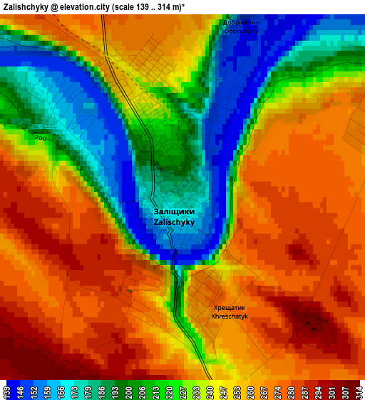
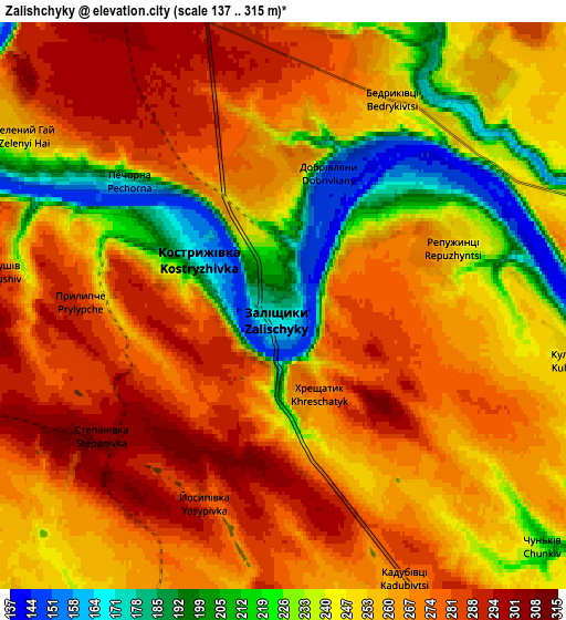
Below is the Elevation map of Zalishchyky, which displays elevation range with different colors. Scale of the first map is from 139 to 314 m (456 to 1030 ft) with average elevation of 240.2 meters (=788 ft) [note 1]
These maps also provides idea of topography and contour of this city, they are displayed at different zoom levels. More info about maps, scale and edge coordinates you can find below images.
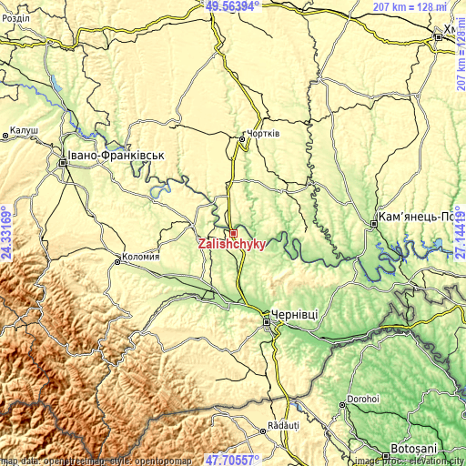
| \ | Map #1 | Map #2 | Topo.Map |
| Scale [m] | 139..314 m | 137..315 m | × |
| Scale [ft] | 456..1030 ft | 449..1033 ft | × |
| Average | 240.2 m = 788 ft | 255.7 m = 839 ft | × |
| Width | 6.46 km = 4 mi | 12.91 km = 8 mi | 206.6 km = 128.4 mi |
| Height | 6.46 km = 4 mi | 12.91 km = 8 mi | 206.6 km = 128.4 mi |
| ↑Max Latitude | 48.672338° | 48.70135° | 49.56394° |
| Latitude at center | 48.64331° | 48.64331° | 48.64331° |
| ↓Min Latitude | 48.614265° | 48.585203° | 47.70557° |
| ← Min Longitude | 25.693995° | 25.650049° | 24.33169° |
| Longitude center | 25.73794° | 25.73794° | 25.73794° |
| →Max Longitude | 25.781885° | 25.825831° | 27.14419° |
Nearby cities:
Cities around Zalishchyky sort by population:
• Borshchiv elevation 253 m
28.6 km,  51°
51°
• Sniatyn 227 m
25.1 km,  209°
209°
• Horodenka 267 m
17.7 km,  280°
280°
• Zastavna 239 m
15.5 km,  149°
149°
• Verenchanka 218 m
10.8 km,  177°
177°
• Tovste 282 m
22.6 km,  357°
357°
• Kadubivtsi 264 m
7 km,  161°
161°
• Stetseva 249 m
17.5 km,  222°
222°
• Chernyatyn 295 m
21.4 km, 275°
• Kostryzhivka 159 m
2.2 km,  304°
304°
• Nyrkiv 330 m
21.6 km,  332°
332°
• Kitsman’ 217 m
22.3 km,  174°
174°
Multilingual:
 En español:
Zalishchyky elevación 179 m.
 En France:
Zalishchyky élévation 179 m.
 Auf Deutsch:
Zalishchyky höhe über dem Meeresspiegel ist 179 m.

Sources and notes:
- [note 1] Map square and city borders are not equal. Map elevation data is calculated only from area inside that square.
- [src 1] Elevation data from geonames database provided with same terms of usage.
- [src 2] The elevation map of Zalishchyky is generated using elevation data from NASA's 3 arcsec (90m) resolution SRTM data.
- [src 3] Base (background) map © OpenStreetMap contributors tiles are generated by Geofabrik and OpenTopoMap.
Copyright & License:
This Zalishchyky Elevation Map is licensed under CC BY-SA. You may reuse any part from this page, if you give a proper credit by linking to this URL:
 More info on terms of use page.