Sniatyn elevation
Sniatyn (Ivano-Frankivsk), Ukraine elevation is 227 meters and Sniatyn elevation in feet is 745 ft above sea level [src 1]. Sniatyn is a seat of a second-order administrative division (feature code) with elevation that is 70 meters (230 ft) bigger than average city elevation in Ukraine.
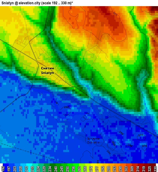
Below is the Elevation map of Sniatyn, which displays elevation range with different colors. Scale of the first map is from 192 to 330 m (630 to 1083 ft) with average elevation of 238.1 meters (=781 ft) [note 1]
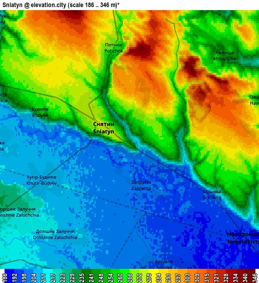
These maps also provides idea of topography and contour of this city, they are displayed at different zoom levels. More info about maps, scale and edge coordinates you can find below images.
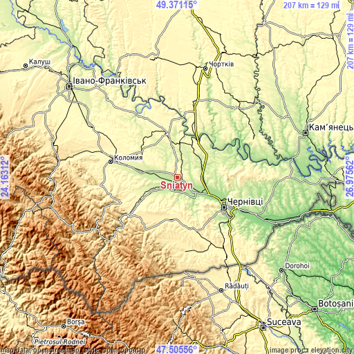
| \ | Map #1 | Map #2 | Topo.Map |
| Scale [m] | 192..330 m | 186..346 m | × |
| Scale [ft] | 630..1083 ft | 610..1135 ft | × |
| Average | 238.1 m = 781 ft | 243.4 m = 799 ft | × |
| Width | 6.48 km = 4 mi | 12.96 km = 8.1 mi | 207.4 km = 128.9 mi |
| Height | 6.48 km = 4 mi | 12.96 km = 8.1 mi | 207.4 km = 128.9 mi |
| ↑Max Latitude | 48.476061° | 48.505186° | 49.37115° |
| Latitude at center | 48.44692° | 48.44692° | 48.44692° |
| ↓Min Latitude | 48.417762° | 48.388587° | 47.50556° |
| ← Min Longitude | 25.525425° | 25.481479° | 24.16312° |
| Longitude center | 25.56937° | 25.56937° | 25.56937° |
| →Max Longitude | 25.613315° | 25.657261° | 26.97562° |
Nearby cities:
Cities around Sniatyn sort by population:
• Zalishchyky elevation 179 m
25.1 km,  29°
29°
• Zastavna 239 m
21.9 km,  67°
67°
• Vashkivtsi 211 m
8.2 km,  212°
212°
• Luzhany 180 m
17.5 km,  121°
121°
• Zabolotiv 233 m
21.1 km,  277°
277°
• Banyliv 253 m
18.8 km,  241°
241°
• Verenchanka 218 m
17.1 km,  49°
49°
• Kadubivtsi 264 m
21.1 km,  44°
44°
• Stetseva 249 m
9 km,  2°
2°
• Chernyatyn 295 m
25.3 km,  339°
339°
• Shypyntsi 182 m
15.2 km, 120°
• Kitsman’ 217 m
14.6 km,  91°
91°
Multilingual:
 En español:
Sniatyn elevación 227 m.
 En France:
Sniatyn élévation 227 m.


Sources and notes:
- [note 1] Map square and city borders are not equal. Map elevation data is calculated only from area inside that square.
- [src 1] Elevation data from geonames database provided with same terms of usage.
- [src 2] The elevation map of Sniatyn is generated using elevation data from NASA's 3 arcsec (90m) resolution SRTM data.
- [src 3] Base (background) map © OpenStreetMap contributors tiles are generated by Geofabrik and OpenTopoMap.
Copyright & License:
This Sniatyn Elevation Map is licensed under CC BY-SA. You may reuse any part from this page, if you give a proper credit by linking to this URL:
 More info on terms of use page.