Brody elevation
Brody (Lviv), Ukraine elevation is 223 meters and Brody elevation in feet is 732 ft above sea level [src 1]. Brody is a seat of a second-order administrative division (feature code) with elevation that is 66 meters (217 ft) bigger than average city elevation in Ukraine.
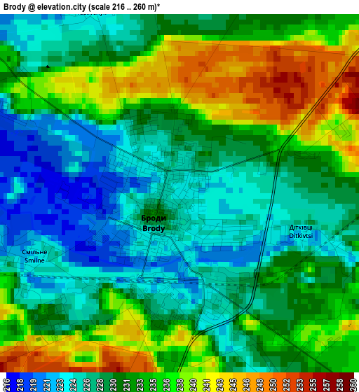
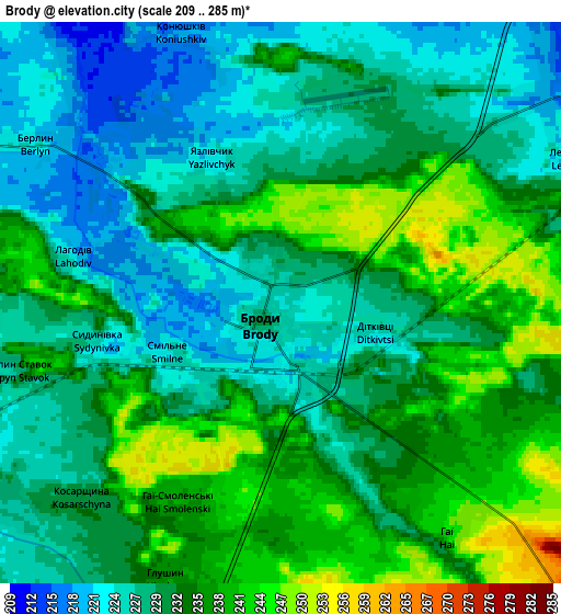
Below is the Elevation map of Brody, which displays elevation range with different colors. Scale of the first map is from 216 to 260 m (709 to 853 ft) with average elevation of 231.3 meters (=759 ft) [note 1]
These maps also provides idea of topography and contour of this city, they are displayed at different zoom levels. More info about maps, scale and edge coordinates you can find below images.
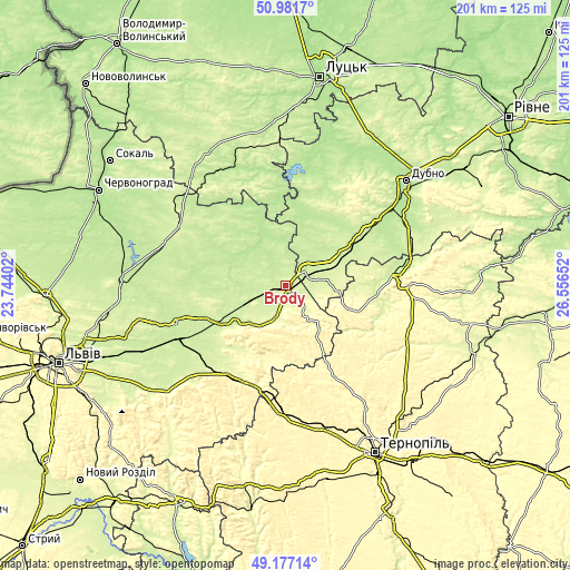
| \ | Map #1 | Map #2 | Topo.Map |
| Scale [m] | 216..260 m | 209..285 m | × |
| Scale [ft] | 709..853 ft | 686..935 ft | × |
| Average | 231.3 m = 759 ft | 231.8 m = 760 ft | × |
| Width | 6.27 km = 3.9 mi | 12.54 km = 7.8 mi | 200.6 km = 124.6 mi |
| Height | 6.27 km = 3.9 mi | 12.54 km = 7.8 mi | 200.6 km = 124.6 mi |
| ↑Max Latitude | 50.116098° | 50.144268° | 50.9817° |
| Latitude at center | 50.08791° | 50.08791° | 50.08791° |
| ↓Min Latitude | 50.059706° | 50.031485° | 49.17714° |
| ← Min Longitude | 25.106325° | 25.062379° | 23.74402° |
| Longitude center | 25.15027° | 25.15027° | 25.15027° |
| →Max Longitude | 25.194215° | 25.238161° | 26.55652° |
Nearby cities:
Cities around Brody sort by population:
• Zolochiv elevation 276 m
36.3 km,  210°
210°
• Radyvyliv 221 m
8.9 km,  58°
58°
• Pochaiv 372 m
27.4 km,  109°
109°
• Kulykiv 214 m
34.6 km,  316°
316°
• Lopatyn 216 m
26.1 km,  304°
304°
• Zaliztsi 360 m
36.6 km,  154°
154°
• Pidkamin’ 368 m
19.8 km,  142°
142°
• Berestechko 190 m
30.4 km,  354°
354°
• Olesko 232 m
23.1 km,  232°
232°
• Pidhirtsi 313 m
19.9 km,  217°
217°
• Bus’k 218 m
40.8 km,  250°
250°
• Demydivka 206 m
40.1 km,  19°
19°
Multilingual:
 En español:
Brody elevación 223 m.
 En France:
Brody élévation 223 m.


Sources and notes:
- [note 1] Map square and city borders are not equal. Map elevation data is calculated only from area inside that square.
- [src 1] Elevation data from geonames database provided with same terms of usage.
- [src 2] The elevation map of Brody is generated using elevation data from NASA's 3 arcsec (90m) resolution SRTM data.
- [src 3] Base (background) map © OpenStreetMap contributors tiles are generated by Geofabrik and OpenTopoMap.
Copyright & License:
This Brody Elevation Map is licensed under CC BY-SA. You may reuse any part from this page, if you give a proper credit by linking to this URL:
 More info on terms of use page.