Pochaiv elevation
Pochaiv (Ternopil), Ukraine elevation is 372 meters and Pochaiv elevation in feet is 1220 ft above sea level [src 1]. Pochaiv is a populated place (feature code) with elevation that is 215 meters (705 ft) bigger than average city elevation in Ukraine.
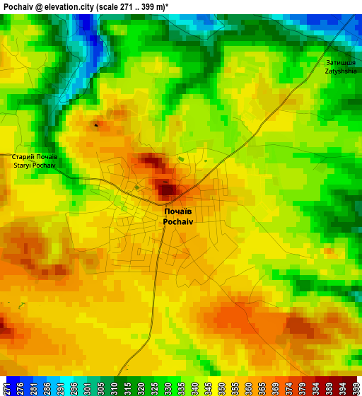
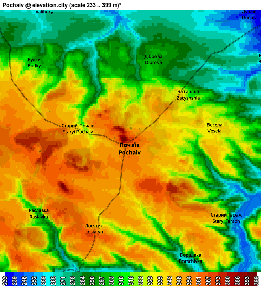
Below is the Elevation map of Pochaiv, which displays elevation range with different colors. Scale of the first map is from 271 to 399 m (889 to 1309 ft) with average elevation of 342.9 meters (=1125 ft) [note 1]
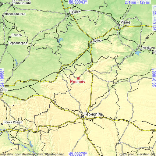
These maps also provides idea of topography and contour of this city, they are displayed at different zoom levels. More info about maps, scale and edge coordinates you can find below images.
| \ | Map #1 | Map #2 | Topo.Map |
| Scale [m] | 271..399 m | 233..399 m | × |
| Scale [ft] | 889..1309 ft | 764..1309 ft | × |
| Average | 342.9 m = 1125 ft | 318.4 m = 1045 ft | × |
| Width | 6.28 km = 3.9 mi | 12.56 km = 7.8 mi | 201 km = 124.9 mi |
| Height | 6.28 km = 3.9 mi | 12.56 km = 7.8 mi | 201 km = 124.9 mi |
| ↑Max Latitude | 50.033326° | 50.061546° | 50.90043° |
| Latitude at center | 50.00509° | 50.00509° | 50.00509° |
| ↓Min Latitude | 49.976837° | 49.948568° | 49.09275° |
| ← Min Longitude | 25.467885° | 25.423939° | 24.10558° |
| Longitude center | 25.51183° | 25.51183° | 25.51183° |
| →Max Longitude | 25.555775° | 25.599721° | 26.91808° |
Nearby cities:
Cities around Pochaiv sort by population:
• Brody elevation 223 m
27.4 km,  289°
289°
• Kremenets 301 m
18.3 km,  56°
56°
• Zbarazh 317 m
42.4 km,  153°
153°
• Radyvyliv 221 m
23 km,  307°
307°
• Lanivtsi 272 m
44.3 km,  110°
110°
• Ozerna 351 m
43.8 km,  197°
197°
• Smyga 225 m
31.7 km,  34°
34°
• Zaliztsi 360 m
25.7 km, 202°
• Pidkamin’ 368 m
15.4 km,  244°
244°
• Olesko 232 m
44.5 km,  263°
263°
• Tarakaniv 204 m
43.9 km,  18°
18°
• Pidhirtsi 313 m
38.6 km, 260°
Multilingual:
 En español:
Pochaiv elevación 372 m.
 En France:
Pochaiv élévation 372 m.


Sources and notes:
- [note 1] Map square and city borders are not equal. Map elevation data is calculated only from area inside that square.
- [src 1] Elevation data from geonames database provided with same terms of usage.
- [src 2] The elevation map of Pochaiv is generated using elevation data from NASA's 3 arcsec (90m) resolution SRTM data.
- [src 3] Base (background) map © OpenStreetMap contributors tiles are generated by Geofabrik and OpenTopoMap.
Copyright & License:
This Pochaiv Elevation Map is licensed under CC BY-SA. You may reuse any part from this page, if you give a proper credit by linking to this URL:
 More info on terms of use page.