Lanivtsi elevation
Lanivtsi (Ternopil), Ukraine elevation is 272 meters and Lanivtsi elevation in feet is 892 ft above sea level [src 1]. Lanivtsi is a seat of a second-order administrative division (feature code) with elevation that is 115 meters (377 ft) bigger than average city elevation in Ukraine.
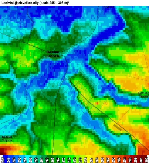
Below is the Elevation map of Lanivtsi, which displays elevation range with different colors. Scale of the first map is from 245 to 303 m (804 to 994 ft) with average elevation of 263.4 meters (=864 ft) [note 1]
These maps also provides idea of topography and contour of this city, they are displayed at different zoom levels. More info about maps, scale and edge coordinates you can find below images.
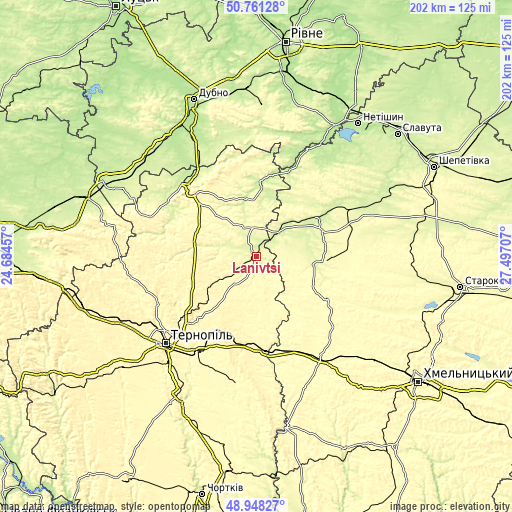
| \ | Map #1 | Map #2 | Topo.Map |
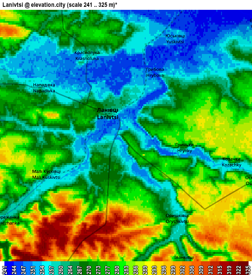
| Scale [m] | 245..303 m | 241..325 m | × |
| Scale [ft] | 804..994 ft | 791..1066 ft | × |
| Average | 263.4 m = 864 ft | 272.3 m = 893 ft | × |
| Width | 6.3 km = 3.9 mi | 12.6 km = 7.8 mi | 201.6 km = 125.3 mi |
| Height | 6.3 km = 3.9 mi | 12.6 km = 7.8 mi | 201.6 km = 125.3 mi |
| ↑Max Latitude | 49.891599° | 49.919902° | 50.76128° |
| Latitude at center | 49.86328° | 49.86328° | 49.86328° |
| ↓Min Latitude | 49.834944° | 49.806591° | 48.94827° |
| ← Min Longitude | 26.046875° | 26.002929° | 24.68457° |
| Longitude center | 26.09082° | 26.09082° | 26.09082° |
| →Max Longitude | 26.134765° | 26.178711° | 27.49707° |
Nearby cities:
Cities around Lanivtsi sort by population:
• Kremenets elevation 301 m
36.9 km,  314°
314°
• Zbarazh 317 m
31.7 km,  225°
225°
• Pochaiv 372 m
44.3 km,  290°
290°
• Skalat 320 m
49.1 km,  189°
189°
• Velikiye Borki 325 m
44.7 km,  212°
212°
• Smyga 225 m
47.8 km,  330°
330°
• Bazaliya 303 m
32.2 km,  121°
121°
• Volochysk 319 m
37.3 km,  166°
166°
• Pidvolochysk 301 m
36.7 km, 173°
• Shumsk 240 m
28.8 km,  3°
3°
• Lyakhovtsy 243 m
28.7 km,  57°
57°
• Teofipol 274 m
23.4 km,  96°
96°
Multilingual:
 En español:
Lanivtsi elevación 272 m.
 En France:
Lanivtsi élévation 272 m.
 Auf Deutsch:
Lanivtsi höhe über dem Meeresspiegel ist 272 m.

Sources and notes:
- [note 1] Map square and city borders are not equal. Map elevation data is calculated only from area inside that square.
- [src 1] Elevation data from geonames database provided with same terms of usage.
- [src 2] The elevation map of Lanivtsi is generated using elevation data from NASA's 3 arcsec (90m) resolution SRTM data.
- [src 3] Base (background) map © OpenStreetMap contributors tiles are generated by Geofabrik and OpenTopoMap.
Copyright & License:
This Lanivtsi Elevation Map is licensed under CC BY-SA. You may reuse any part from this page, if you give a proper credit by linking to this URL:
 More info on terms of use page.