Chornorudka elevation
Chornorudka (Zhytomyr), Ukraine elevation is 241 meters and Chornorudka elevation in feet is 791 ft above sea level [src 1]. Chornorudka is a populated place (feature code) with elevation that is 84 meters (276 ft) bigger than average city elevation in Ukraine.
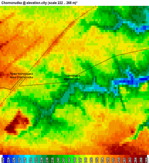
Below is the Elevation map of Chornorudka, which displays elevation range with different colors. Scale of the first map is from 222 to 268 m (728 to 879 ft) with average elevation of 247.4 meters (=812 ft) [note 1]
These maps also provides idea of topography and contour of this city, they are displayed at different zoom levels. More info about maps, scale and edge coordinates you can find below images.
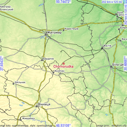
| \ | Map #1 | Topo.Map |
| Scale [m] | 222..268 m | × |
| Scale [ft] | 728..879 ft | × |
| Average | 247.4 m = 812 ft | × |
| Width | 6.3 km = 3.9 mi | 201.7 km = 125.3 mi |
| Height | 6.3 km = 3.9 mi | 201.6 km = 125.3 mi |
| ↑Max Latitude | 49.874729° | 50.74472° |
| Latitude at center | 49.8464° | 49.8464° |
| ↓Min Latitude | 49.818054° | 48.93108° |
| ← Min Longitude | 29.016675° | 27.65437° |
| Longitude center | 29.06062° | 29.06062° |
| →Max Longitude | 29.104565° | 30.46687° |
Nearby cities:
Cities around Chornorudka sort by population:
• Berdychiv elevation 250 m
33.4 km,  280°
280°
• Kozyatyn 293 m
21.9 km,  227°
227°
• Pohrebyshche 228 m
42.6 km,  159°
159°
• Andrushivka 212 m
19.8 km,  351°
351°
• Popilnia 206 m
30.5 km,  67°
67°
• Ozerne 220 m
43.7 km,  327°
327°
• Ruzhyn 227 m
17.2 km,  143°
143°
• Hryshkivtsi 261 m
34.2 km,  286°
286°
• Chervone 230 m
17.9 km,  309°
309°
• Kornyn 198 m
43.8 km,  50°
50°
• Topory 226 m
28.4 km, 139°
• Andrushky 212 m
20.7 km,  78°
78°
Multilingual:
 En español:
Chornorudka elevación 241 m.
 En France:
Chornorudka élévation 241 m.
 Auf Deutsch:
Chornorudka höhe über dem Meeresspiegel ist 241 m.

Sources and notes:
- [note 1] Map square and city borders are not equal. Map elevation data is calculated only from area inside that square.
- [src 1] Elevation data from geonames database provided with same terms of usage.
- [src 2] The elevation map of Chornorudka is generated using elevation data from NASA's 3 arcsec (90m) resolution SRTM data.
- [src 3] Base (background) map © OpenStreetMap contributors tiles are generated by Geofabrik and OpenTopoMap.
Copyright & License:
This Chornorudka Elevation Map is licensed under CC BY-SA. You may reuse any part from this page, if you give a proper credit by linking to this URL:
 More info on terms of use page.