Topory elevation
Topory (Zhytomyr), Ukraine elevation is 226 meters and Topory elevation in feet is 741 ft above sea level [src 1]. Topory is a populated place (feature code) with elevation that is 69 meters (226 ft) bigger than average city elevation in Ukraine.
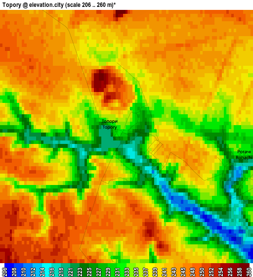
Below is the Elevation map of Topory, which displays elevation range with different colors. Scale of the first map is from 206 to 260 m (676 to 853 ft) with average elevation of 238.7 meters (=783 ft) [note 1]
These maps also provides idea of topography and contour of this city, they are displayed at different zoom levels. More info about maps, scale and edge coordinates you can find below images.
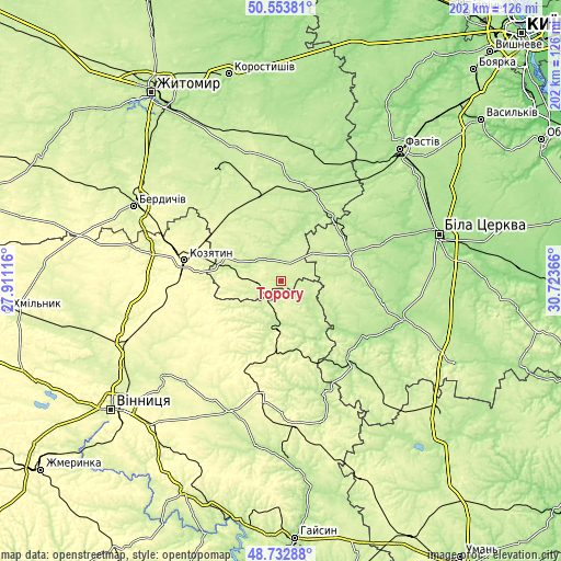
| \ | Map #1 | Topo.Map |
| Scale [m] | 206..260 m | × |
| Scale [ft] | 676..853 ft | × |
| Average | 238.7 m = 783 ft | × |
| Width | 6.33 km = 3.9 mi | 202.5 km = 125.8 mi |
| Height | 6.33 km = 3.9 mi | 202.5 km = 125.8 mi |
| ↑Max Latitude | 49.680303° | 50.55381° |
| Latitude at center | 49.65186° | 49.65186° |
| ↓Min Latitude | 49.6234° | 48.73288° |
| ← Min Longitude | 29.273465° | 27.91116° |
| Longitude center | 29.31741° | 29.31741° |
| →Max Longitude | 29.361355° | 30.72366° |
Nearby cities:
Cities around Topory sort by population:
• Kozyatyn elevation 293 m
35.5 km,  281°
281°
• Skvyra 201 m
26.6 km,  70°
70°
• Tetiiv 195 m
39.6 km,  140°
140°
• Pohrebyshche 228 m
18.8 km,  191°
191°
• Andrushivka 212 m
46.4 km,  332°
332°
• Volodarka 172 m
45.1 km,  108°
108°
• Popilnia 206 m
34.9 km,  16°
16°
• Ruzhyn 227 m
11.3 km,  314°
314°
• Chervone 230 m
46.2 km,  315°
315°
• Kozhanka 181 m
47.9 km,  41°
41°
• Chornorudka 241 m
28.4 km, 319°
• Andrushky 212 m
25.7 km,  4°
4°
Multilingual:
 En español:
Topory elevación 226 m.
 En France:
Topory élévation 226 m.


Sources and notes:
- [note 1] Map square and city borders are not equal. Map elevation data is calculated only from area inside that square.
- [src 1] Elevation data from geonames database provided with same terms of usage.
- [src 2] The elevation map of Topory is generated using elevation data from NASA's 3 arcsec (90m) resolution SRTM data.
- [src 3] Base (background) map © OpenStreetMap contributors tiles are generated by Geofabrik and OpenTopoMap.
Copyright & License:
This Topory Elevation Map is licensed under CC BY-SA. You may reuse any part from this page, if you give a proper credit by linking to this URL:
 More info on terms of use page.