Ozerne elevation
Ozerne (Zhytomyr), Ukraine elevation is 220 meters and Ozerne elevation in feet is 722 ft above sea level [src 1]. Ozerne is a populated place (feature code) with elevation that is 63 meters (207 ft) bigger than average city elevation in Ukraine.
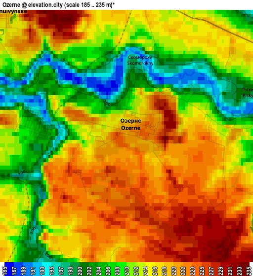
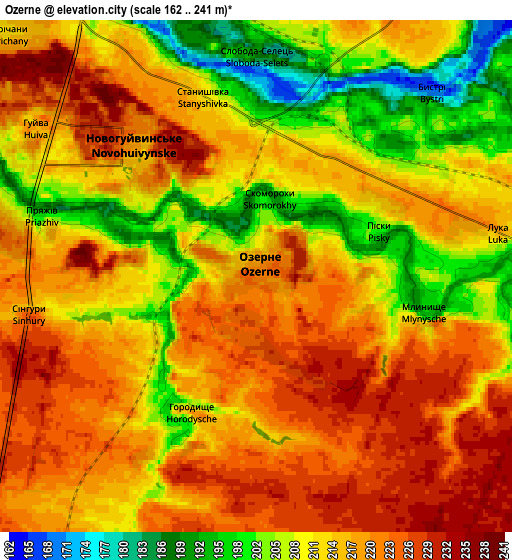
Below is the Elevation map of Ozerne, which displays elevation range with different colors. Scale of the first map is from 185 to 235 m (607 to 771 ft) with average elevation of 214.4 meters (=703 ft) [note 1]
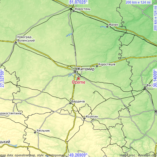
These maps also provides idea of topography and contour of this city, they are displayed at different zoom levels. More info about maps, scale and edge coordinates you can find below images.
| \ | Map #1 | Map #2 | Topo.Map |
| Scale [m] | 185..235 m | 162..241 m | × |
| Scale [ft] | 607..771 ft | 531..791 ft | × |
| Average | 214.4 m = 703 ft | 214 m = 702 ft | × |
| Width | 6.26 km = 3.9 mi | 12.52 km = 7.8 mi | 200.3 km = 124.5 mi |
| Height | 6.26 km = 3.9 mi | 12.52 km = 7.8 mi | 200.3 km = 124.5 mi |
| ↑Max Latitude | 50.206294° | 50.234412° | 51.07025° |
| Latitude at center | 50.17816° | 50.17816° | 50.17816° |
| ↓Min Latitude | 50.150009° | 50.121841° | 49.26909° |
| ← Min Longitude | 28.689895° | 28.645949° | 27.32759° |
| Longitude center | 28.73384° | 28.73384° | 28.73384° |
| →Max Longitude | 28.777785° | 28.821731° | 30.14009° |
Nearby cities:
Cities around Ozerne sort by population:
• Zhytomyr elevation 228 m
10.5 km,  337°
337°
• Berdychiv 250 m
32.4 km,  196°
196°
• Korostyshiv 180 m
27.7 km,  56°
56°
• Cherniakhiv 226 m
31.3 km,  351°
351°
• Andrushivka 212 m
26.7 km,  130°
130°
• Chudniv 246 m
46.1 km,  252°
252°
• Hryshkivtsi 261 m
28.6 km, 198°
• Chervone 230 m
27.2 km,  159°
159°
• Holovyne 205 m
33.2 km,  11°
11°
• Denyshi 210 m
23.8 km,  279°
279°
• Chornorudka 241 m
43.7 km,  147°
147°
• Pulyny 233 m
46 km,  314°
314°
Multilingual:
 En español:
Ozerne elevación 220 m.
 En France:
Ozerne élévation 220 m.


Sources and notes:
- [note 1] Map square and city borders are not equal. Map elevation data is calculated only from area inside that square.
- [src 1] Elevation data from geonames database provided with same terms of usage.
- [src 2] The elevation map of Ozerne is generated using elevation data from NASA's 3 arcsec (90m) resolution SRTM data.
- [src 3] Base (background) map © OpenStreetMap contributors tiles are generated by Geofabrik and OpenTopoMap.
Copyright & License:
This Ozerne Elevation Map is licensed under CC BY-SA. You may reuse any part from this page, if you give a proper credit by linking to this URL:
 More info on terms of use page.