Drabiv elevation
Drabiv (Cherkasy), Ukraine elevation is 119 meters and Drabiv elevation in feet is 390 ft above sea level [src 1]. Drabiv is a seat of a second-order administrative division (feature code) with elevation that is 38 meters (125 ft) smaller than average city elevation in Ukraine.
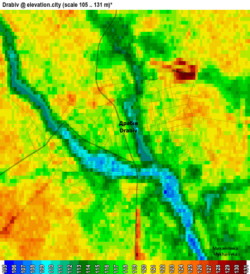
Below is the Elevation map of Drabiv, which displays elevation range with different colors. Scale of the first map is from 105 to 131 m (344 to 430 ft) with average elevation of 118 meters (=387 ft) [note 1]
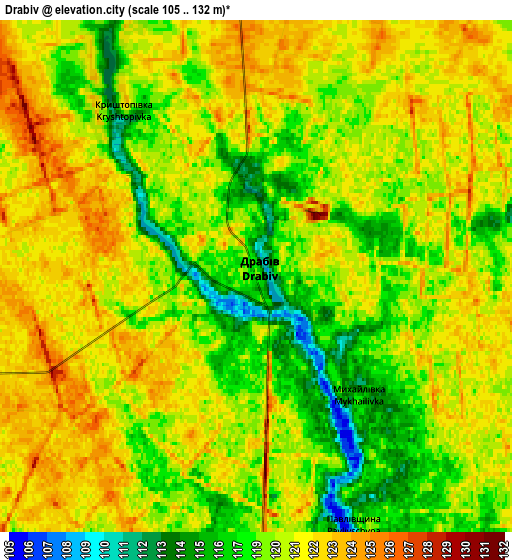
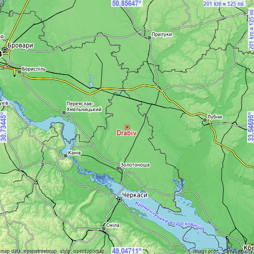
These maps also provides idea of topography and contour of this city, they are displayed at different zoom levels. More info about maps, scale and edge coordinates you can find below images.
| \ | Map #1 | Map #2 | Topo.Map |
| Scale [m] | 105..131 m | 105..132 m | × |
| Scale [ft] | 344..430 ft | 344..433 ft | × |
| Average | 118 m = 387 ft | 119.9 m = 393 ft | × |
| Width | 6.29 km = 3.9 mi | 12.57 km = 7.8 mi | 201.2 km = 125 mi |
| Height | 6.29 km = 3.9 mi | 12.57 km = 7.8 mi | 201.2 km = 125 mi |
| ↑Max Latitude | 49.988553° | 50.016798° | 50.85647° |
| Latitude at center | 49.96029° | 49.96029° | 49.96029° |
| ↓Min Latitude | 49.932011° | 49.903715° | 49.04711° |
| ← Min Longitude | 32.096755° | 32.052809° | 30.73445° |
| Longitude center | 32.1407° | 32.1407° | 32.1407° |
| →Max Longitude | 32.184645° | 32.228591° | 33.54695° |
Nearby cities:
Cities around Drabiv sort by population:
• Cherkasy elevation 107 m
59.4 km,  185°
185°
• Pereiaslav-Khmelnytskyi 88 m
50.8 km,  283°
283°
• Zolotonosha 93 m
33.3 km, 192°
• Kaniv 126 m
54 km,  244°
244°
• Yahotyn 130 m
44.6 km,  322°
322°
• Pyryatyn 119 m
40.8 km,  39°
39°
• Hrebinka 113 m
27.4 km,  50°
50°
• Chornobay 116 m
35.4 km,  157°
157°
• Moshny 82 m
56.2 km,  211°
211°
• Orzhytsya 99 m
44.3 km,  115°
115°
• Tsybli 112 m
41.5 km, 275°
• Chernyakhivka 124 m
32.4 km,  332°
332°
Multilingual:
 En español:
Drabiv elevación 119 m.
 En France:
Drabiv élévation 119 m.


Sources and notes:
- [note 1] Map square and city borders are not equal. Map elevation data is calculated only from area inside that square.
- [src 1] Elevation data from geonames database provided with same terms of usage.
- [src 2] The elevation map of Drabiv is generated using elevation data from NASA's 3 arcsec (90m) resolution SRTM data.
- [src 3] Base (background) map © OpenStreetMap contributors tiles are generated by Geofabrik and OpenTopoMap.
Copyright & License:
This Drabiv Elevation Map is licensed under CC BY-SA. You may reuse any part from this page, if you give a proper credit by linking to this URL:
 More info on terms of use page.