Orzhytsya elevation
Orzhytsya (Poltava), Ukraine elevation is 99 meters and Orzhytsya elevation in feet is 325 ft above sea level [src 1]. Orzhytsya is a seat of a second-order administrative division (feature code) with elevation that is 58 meters (190 ft) smaller than average city elevation in Ukraine.
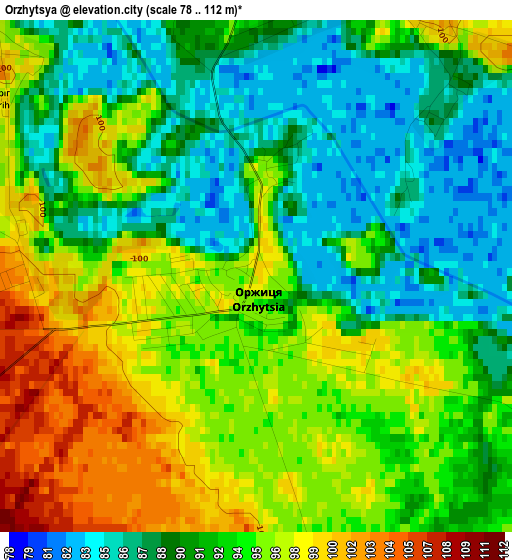
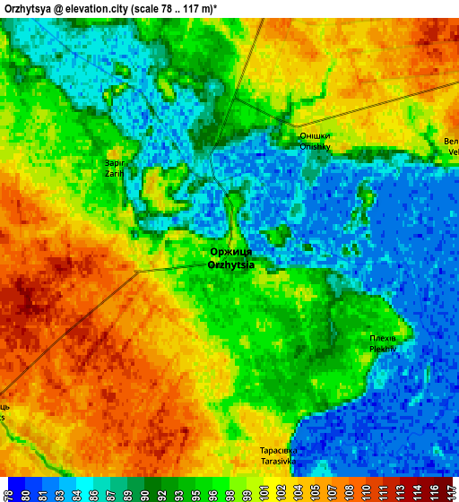
Below is the Elevation map of Orzhytsya, which displays elevation range with different colors. Scale of the first map is from 78 to 112 m (256 to 367 ft) with average elevation of 92.6 meters (=304 ft) [note 1]
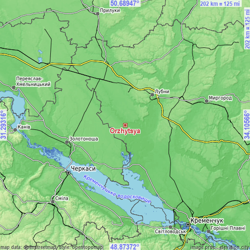
These maps also provides idea of topography and contour of this city, they are displayed at different zoom levels. More info about maps, scale and edge coordinates you can find below images.
| \ | Map #1 | Map #2 | Topo.Map |
| Scale [m] | 78..112 m | 78..117 m | × |
| Scale [ft] | 256..367 ft | 256..384 ft | × |
| Average | 92.6 m = 304 ft | 95.3 m = 313 ft | × |
| Width | 6.31 km = 3.9 mi | 12.62 km = 7.8 mi | 201.9 km = 125.5 mi |
| Height | 6.31 km = 3.9 mi | 12.62 km = 7.8 mi | 201.9 km = 125.5 mi |
| ↑Max Latitude | 49.818462° | 49.846808° | 50.68947° |
| Latitude at center | 49.7901° | 49.7901° | 49.7901° |
| ↓Min Latitude | 49.761721° | 49.733325° | 48.87372° |
| ← Min Longitude | 32.655465° | 32.611519° | 31.29316° |
| Longitude center | 32.69941° | 32.69941° | 32.69941° |
| →Max Longitude | 32.743355° | 32.787301° | 34.10566° |
Nearby cities:
Cities around Orzhytsya sort by population:
• Lubny elevation 153 m
33 km,  40°
40°
• Zolotonosha 93 m
49.3 km,  254°
254°
• Pyryatyn 119 m
52.2 km,  344°
344°
• Khorol 116 m
41.6 km,  90°
90°
• Hlobyne 95 m
60.3 km,  137°
137°
• Hrebinka 113 m
41 km,  332°
332°
• Chervona Sloboda 83 m
60.7 km,  220°
220°
• Chornobay 116 m
29.9 km,  242°
242°
• Semenivka 92 m
41.1 km,  122°
122°
• Drabiv 119 m
44.3 km,  295°
295°
• Romodan 151 m
50.1 km,  63°
63°
• Chornukhy 114 m
55.8 km,  18°
18°
Multilingual:
 En español:
Orzhytsya elevación 99 m.
 En France:
Orzhytsya élévation 99 m.
 Auf Deutsch:
Orzhytsya höhe über dem Meeresspiegel ist 99 m.

Sources and notes:
- [note 1] Map square and city borders are not equal. Map elevation data is calculated only from area inside that square.
- [src 1] Elevation data from geonames database provided with same terms of usage.
- [src 2] The elevation map of Orzhytsya is generated using elevation data from NASA's 3 arcsec (90m) resolution SRTM data.
- [src 3] Base (background) map © OpenStreetMap contributors tiles are generated by Geofabrik and OpenTopoMap.
Copyright & License:
This Orzhytsya Elevation Map is licensed under CC BY-SA. You may reuse any part from this page, if you give a proper credit by linking to this URL:
 More info on terms of use page.