Hrebinka elevation
Hrebinka (Poltava), Ukraine elevation is 113 meters and Hrebinka elevation in feet is 371 ft above sea level [src 1]. Hrebinka is a seat of a second-order administrative division (feature code) with elevation that is 44 meters (144 ft) smaller than average city elevation in Ukraine.
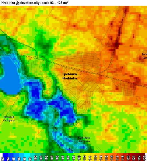
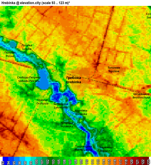
Below is the Elevation map of Hrebinka, which displays elevation range with different colors. Scale of the first map is from 93 to 123 m (305 to 404 ft) with average elevation of 109.3 meters (=359 ft) [note 1]
These maps also provides idea of topography and contour of this city, they are displayed at different zoom levels. More info about maps, scale and edge coordinates you can find below images.
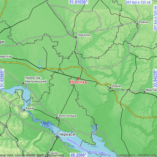
| \ | Map #1 | Map #2 | Topo.Map |
| Scale [m] | 93..123 m | 93..123 m | × |
| Scale [ft] | 305..404 ft | 305..404 ft | × |
| Average | 109.3 m = 359 ft | 110.3 m = 362 ft | × |
| Width | 6.27 km = 3.9 mi | 12.53 km = 7.8 mi | 200.5 km = 124.6 mi |
| Height | 6.27 km = 3.9 mi | 12.53 km = 7.8 mi | 200.5 km = 124.6 mi |
| ↑Max Latitude | 50.14529° | 50.173444° | 51.01036° |
| Latitude at center | 50.11712° | 50.11712° | 50.11712° |
| ↓Min Latitude | 50.088933° | 50.06073° | 49.2069° |
| ← Min Longitude | 32.392155° | 32.348209° | 31.02985° |
| Longitude center | 32.4361° | 32.4361° | 32.4361° |
| →Max Longitude | 32.480045° | 32.523991° | 33.84235° |
Nearby cities:
Cities around Hrebinka sort by population:
• Pryluky elevation 127 m
53.1 km,  356°
356°
• Lubny 153 m
41.6 km,  105°
105°
• Yahotyn 130 m
51.2 km,  290°
290°
• Pyryatyn 119 m
14.8 km,  19°
19°
• Varva 128 m
46.6 km,  25°
25°
• Chornobay 116 m
50.7 km,  188°
188°
• Drabiv 119 m
27.4 km,  230°
230°
• Ladan 155 m
45.9 km,  13°
13°
• Orzhytsya 99 m
41 km,  152°
152°
• Chornukhy 114 m
39.7 km,  65°
65°
• Zhuravka 106 m
42 km, 15°
• Chernyakhivka 124 m
37.7 km, 287°
Multilingual:
 En español:
Hrebinka elevación 113 m.
 En France:
Hrebinka élévation 113 m.
 Auf Deutsch:
Hrebinka höhe über dem Meeresspiegel ist 113 m.

Sources and notes:
- [note 1] Map square and city borders are not equal. Map elevation data is calculated only from area inside that square.
- [src 1] Elevation data from geonames database provided with same terms of usage.
- [src 2] The elevation map of Hrebinka is generated using elevation data from NASA's 3 arcsec (90m) resolution SRTM data.
- [src 3] Base (background) map © OpenStreetMap contributors tiles are generated by Geofabrik and OpenTopoMap.
Copyright & License:
This Hrebinka Elevation Map is licensed under CC BY-SA. You may reuse any part from this page, if you give a proper credit by linking to this URL:
 More info on terms of use page.