Cherkasy elevation
Cherkasy, Ukraine elevation is 107 meters and Cherkasy elevation in feet is 351 ft above sea level [src 1]. Cherkasy is a seat of a first-order administrative division (feature code) with elevation that is 50 meters (164 ft) smaller than average city elevation in Ukraine.
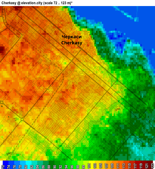
Below is the Elevation map of Cherkasy, which displays elevation range with different colors. Scale of the first map is from 72 to 123 m (236 to 404 ft) with average elevation of 99.2 meters (=325 ft) [note 1]
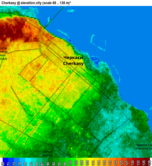
These maps also provides idea of topography and contour of this city, they are displayed at different zoom levels. More info about maps, scale and edge coordinates you can find below images.
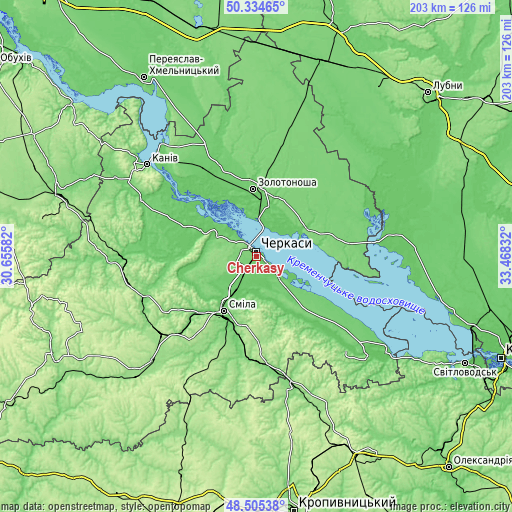
| \ | Map #1 | Map #2 | Topo.Map |
| Scale [m] | 72..123 m | 68..138 m | × |
| Scale [ft] | 236..404 ft | 223..453 ft | × |
| Average | 99.2 m = 325 ft | 93.7 m = 307 ft | × |
| Width | 6.36 km = 4 mi | 12.71 km = 7.9 mi | 203.4 km = 126.4 mi |
| Height | 6.36 km = 4 mi | 12.71 km = 7.9 mi | 203.4 km = 126.4 mi |
| ↑Max Latitude | 49.457114° | 49.48567° | 50.33465° |
| Latitude at center | 49.42854° | 49.42854° | 49.42854° |
| ↓Min Latitude | 49.39995° | 49.371343° | 48.50538° |
| ← Min Longitude | 32.018125° | 31.974179° | 30.65582° |
| Longitude center | 32.06207° | 32.06207° | 32.06207° |
| →Max Longitude | 32.106015° | 32.149961° | 33.46832° |
Nearby cities:
Cities around Cherkasy sort by population:
• Smila elevation 101 m
26.2 km,  208°
208°
• Zolotonosha 93 m
26.7 km,  356°
356°
• Kaniv 126 m
56.3 km,  309°
309°
• Horodyshche 114 m
47.4 km,  250°
250°
• Kamianka 127 m
44.2 km,  176°
176°
• Oleksandrivka 127 m
53.2 km,  166°
166°
• Chervona Sloboda 83 m
9.3 km,  131°
131°
• Chornobay 116 m
32.7 km,  36°
36°
• Ruska Poliana 116 m
10.3 km,  262°
262°
• Moshny 82 m
25.9 km,  295°
295°
• Mliiv 90 m
40.7 km, 255°
• Tsvitkove 175 m
48.9 km,  231°
231°
Multilingual:
 En español:
Cherkasy elevación 107 m.
 En France:
Tcherkassy élévation 107 m.
 Auf Deutsch:
Tscherkassy höhe über dem Meeresspiegel ist 107 m.

Sources and notes:
- [note 1] Map square and city borders are not equal. Map elevation data is calculated only from area inside that square.
- [src 1] Elevation data from geonames database provided with same terms of usage.
- [src 2] The elevation map of Cherkasy is generated using elevation data from NASA's 3 arcsec (90m) resolution SRTM data.
- [src 3] Base (background) map © OpenStreetMap contributors tiles are generated by Geofabrik and OpenTopoMap.
Copyright & License:
This Cherkasy Elevation Map is licensed under CC BY-SA. You may reuse any part from this page, if you give a proper credit by linking to this URL:
 More info on terms of use page.