Sokolinoye elevation
Sokolinoye (Republic of Crimea, Bakhchysarai Raion), Ukraine elevation is 270 meters and Sokolinoye elevation in feet is 886 ft above sea level [src 1]. Sokolinoye is a populated place (feature code) with elevation that is 113 meters (371 ft) bigger than average city elevation in Ukraine.
Below is the Elevation map of Sokolinoye, which displays elevation range with different colors. Scale of the first map is from 205 to 1086 m (673 to 3563 ft) with average elevation of 498 meters (=1634 ft) [note 1]
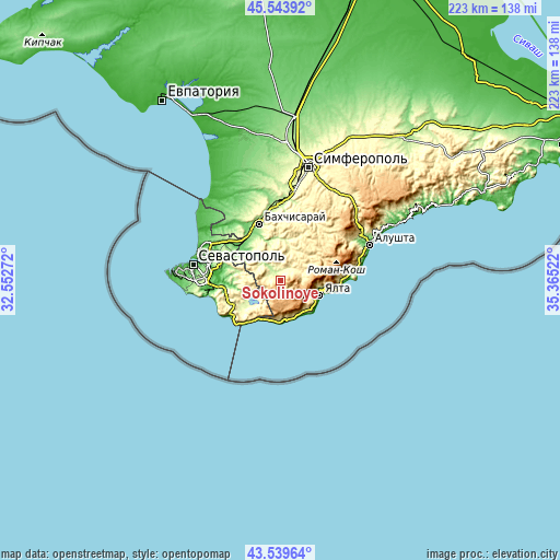
These maps also provides idea of topography and contour of this city, they are displayed at different zoom levels. More info about maps, scale and edge coordinates you can find below images.
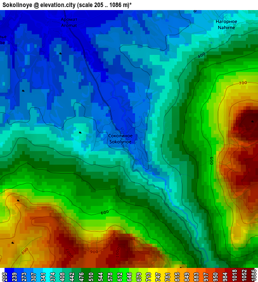
| \ | Map #1 | Topo.Map |
| Scale [m] | 205..1086 m | × |
| Scale [ft] | 673..3563 ft | × |
| Average | 498 m = 1634 ft | × |
| Width | 6.96 km = 4.3 mi | 222.9 km = 138.5 mi |
| Height | 6.96 km = 4.3 mi | 222.8 km = 138.4 mi |
| ↑Max Latitude | 44.581718° | 45.54392° |
| Latitude at center | 44.55041° | 44.55041° |
| ↓Min Latitude | 44.519085° | 43.53964° |
| ← Min Longitude | 33.915025° | 32.55272° |
| Longitude center | 33.95897° | 33.95897° |
| →Max Longitude | 34.002915° | 35.36522° |
Nearby cities:
Cities around Sokolinoye sort by population:
• Yalta elevation 56 m
17.3 km,  108°
108°
• Alupka 84 m
16.2 km,  155°
155°
• Koreiz 170 m
16.4 km,  142°
142°
• Simeiz 75 m
16.5 km,  166°
166°
• Kuibyshevo 159 m
11.3 km,  320°
320°
• Ternovka 192 m
16.8 km,  281°
281°
• Tankovoye 150 m
16.9 km, 315°
• Vinogradnoye 233 m
15.6 km,  119°
119°
• Golubinka 198 m
5.9 km, 324°
• Verkhorechye 238 m
16.5 km,  7°
7°
• Livadia 160 m
17.1 km, 121°
• Zelyonoye 297 m
6.4 km,  38°
38°
Multilingual:
 En español:
Sokolinoye elevación 270 m.
 En France:
Sokolinoye élévation 270 m.
 Auf Deutsch:
Sokolinoye höhe über dem Meeresspiegel ist 270 m.

Sources and notes:
- [note 1] Map square and city borders are not equal. Map elevation data is calculated only from area inside that square.
- [src 1] Elevation data from geonames database provided with same terms of usage.
- [src 2] The elevation map of Sokolinoye is generated using elevation data from NASA's 3 arcsec (90m) resolution SRTM data.
- [src 3] Base (background) map © OpenStreetMap contributors tiles are generated by Geofabrik and OpenTopoMap.
Copyright & License:
This Sokolinoye Elevation Map is licensed under CC BY-SA. You may reuse any part from this page, if you give a proper credit by linking to this URL:
 More info on terms of use page.