Yalta elevation
Yalta (Republic of Crimea, Gorodskoy okrug Yalta), Ukraine elevation is 56 meters and Yalta elevation in feet is 184 ft above sea level [src 1]. Yalta is a seat of a second-order administrative division (feature code) with elevation that is 101 meters (331 ft) smaller than average city elevation in Ukraine.
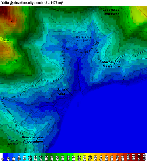
Below is the Elevation map of Yalta, which displays elevation range with different colors. Scale of the first map is from -2 to 1176 m (-7 to 3858 ft) with average elevation of 193.6 meters (=635 ft) [note 1]
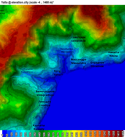
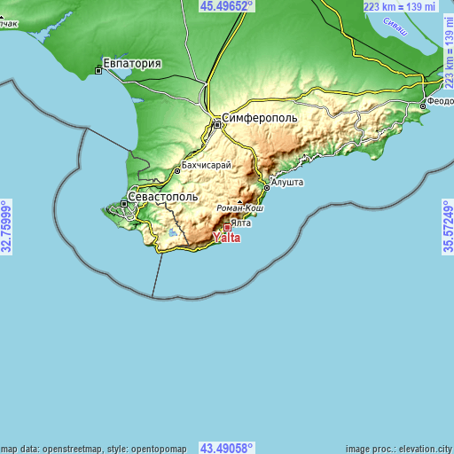
These maps also provides idea of topography and contour of this city, they are displayed at different zoom levels. More info about maps, scale and edge coordinates you can find below images.
| \ | Map #1 | Map #2 | Topo.Map |
| Scale [m] | -2..1176 m | -4..1468 m | × |
| Scale [ft] | -7..3858 ft | -13..4816 ft | × |
| Average | 193.6 m = 635 ft | 447.7 m = 1469 ft | × |
| Width | 6.97 km = 4.3 mi | 13.94 km = 8.7 mi | 223 km = 138.6 mi |
| Height | 6.97 km = 4.3 mi | 13.94 km = 8.7 mi | 223 km = 138.6 mi |
| ↑Max Latitude | 44.533514° | 44.564832° | 45.49652° |
| Latitude at center | 44.50218° | 44.50218° | 44.50218° |
| ↓Min Latitude | 44.470829° | 44.439461° | 43.49058° |
| ← Min Longitude | 34.122295° | 34.078349° | 32.75999° |
| Longitude center | 34.16624° | 34.16624° | 34.16624° |
| →Max Longitude | 34.210185° | 34.254131° | 35.57249° |
Nearby cities:
Cities around Yalta sort by population:
• Gaspra elevation 108 m
9.1 km,  213°
213°
• Gurzuf 81 m
10.2 km,  61°
61°
• Alupka 84 m
13.4 km,  225°
225°
• Massandra 216 m
1.9 km, 64°
• Partenit 70 m
16.5 km, 59°
• Koreiz 170 m
10 km,  220°
220°
• Simeiz 75 m
16.5 km, 229°
• Nikita 261 m
5.9 km,  75°
75°
• Vinogradnoye 233 m
3.7 km, 231°
• Livadia 160 m
4 km, 207°
• Krasnokamenka 255 m
11.9 km,  54°
54°
• Zelyonoye 297 m
16.2 km,  309°
309°
Multilingual:
 En español:
Yalta elevación 56 m.
 En France:
Yalta élévation 56 m.


Sources and notes:
- [note 1] Map square and city borders are not equal. Map elevation data is calculated only from area inside that square.
- [src 1] Elevation data from geonames database provided with same terms of usage.
- [src 2] The elevation map of Yalta is generated using elevation data from NASA's 3 arcsec (90m) resolution SRTM data.
- [src 3] Base (background) map © OpenStreetMap contributors tiles are generated by Geofabrik and OpenTopoMap.
Copyright & License:
This Yalta Elevation Map is licensed under CC BY-SA. You may reuse any part from this page, if you give a proper credit by linking to this URL:
 More info on terms of use page.