Verkhorechye elevation
Verkhorechye (Republic of Crimea, Bakhchysarai Raion), Ukraine elevation is 238 meters and Verkhorechye elevation in feet is 781 ft above sea level [src 1]. Verkhorechye is a seat of a third-order administrative division (feature code) with elevation that is 81 meters (266 ft) bigger than average city elevation in Ukraine.
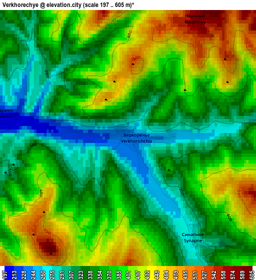
Below is the Elevation map of Verkhorechye, which displays elevation range with different colors. Scale of the first map is from 197 to 605 m (646 to 1985 ft) with average elevation of 368.5 meters (=1209 ft) [note 1]
These maps also provides idea of topography and contour of this city, they are displayed at different zoom levels. More info about maps, scale and edge coordinates you can find below images.
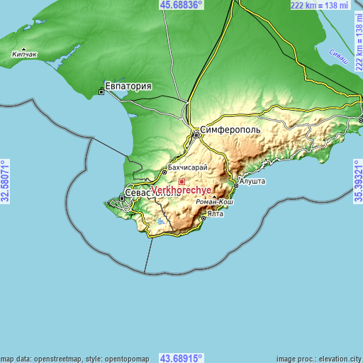
| \ | Map #1 | Topo.Map |
| Scale [m] | 197..605 m | × |
| Scale [ft] | 646..1985 ft | × |
| Average | 368.5 m = 1209 ft | × |
| Width | 6.95 km = 4.3 mi | 222.3 km = 138.1 mi |
| Height | 6.95 km = 4.3 mi | 222.3 km = 138.1 mi |
| ↑Max Latitude | 44.728609° | 45.68836° |
| Latitude at center | 44.69738° | 44.69738° |
| ↓Min Latitude | 44.666134° | 43.68915° |
| ← Min Longitude | 33.943015° | 32.58071° |
| Longitude center | 33.98696° | 33.98696° |
| →Max Longitude | 34.030905° | 35.39321° |
Nearby cities:
Cities around Verkhorechye sort by population:
• Bakhchysarai elevation 173 m
12.1 km,  302°
302°
• Poshtove 186 m
15.5 km,  352°
352°
• Skalistoye 219 m
13.3 km,  356°
356°
• Kuibyshevo 159 m
12 km,  230°
230°
• Tankovoye 150 m
14.7 km,  252°
252°
• Golubinka 198 m
12.8 km,  206°
206°
• Turgenevka 178 m
12.4 km,  270°
270°
• Sokolinoye 270 m
16.5 km,  187°
187°
• Kashtanovoye 275 m
16 km,  20°
20°
• Zheleznodorozhnoye 106 m
14.6 km,  278°
278°
• Aromatnoye 299 m
15 km,  322°
322°
• Zelyonoye 297 m
11.4 km,  171°
171°
Multilingual:
 En español:
Verkhorechye elevación 238 m.
 En France:
Verkhorechye élévation 238 m.
 Auf Deutsch:
Verkhorechye höhe über dem Meeresspiegel ist 238 m.

Sources and notes:
- [note 1] Map square and city borders are not equal. Map elevation data is calculated only from area inside that square.
- [src 1] Elevation data from geonames database provided with same terms of usage.
- [src 2] The elevation map of Verkhorechye is generated using elevation data from NASA's 3 arcsec (90m) resolution SRTM data.
- [src 3] Base (background) map © OpenStreetMap contributors tiles are generated by Geofabrik and OpenTopoMap.
Copyright & License:
This Verkhorechye Elevation Map is licensed under CC BY-SA. You may reuse any part from this page, if you give a proper credit by linking to this URL:
 More info on terms of use page.