Tankovoye elevation
Tankovoye (Republic of Crimea, Bakhchysarai Raion), Ukraine elevation is 150 meters and Tankovoye elevation in feet is 492 ft above sea level [src 1]. Tankovoye is a populated place (feature code) with elevation that is 7 meters (23 ft) smaller than average city elevation in Ukraine.
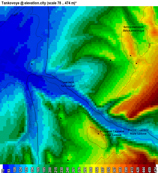
Below is the Elevation map of Tankovoye, which displays elevation range with different colors. Scale of the first map is from 78 to 474 m (256 to 1555 ft) with average elevation of 201.7 meters (=662 ft) [note 1]
These maps also provides idea of topography and contour of this city, they are displayed at different zoom levels. More info about maps, scale and edge coordinates you can find below images.
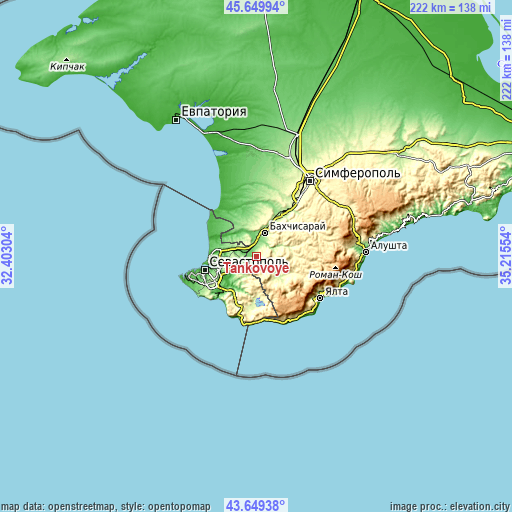
| \ | Map #1 | Topo.Map |
| Scale [m] | 78..474 m | × |
| Scale [ft] | 256..1555 ft | × |
| Average | 201.7 m = 662 ft | × |
| Width | 6.95 km = 4.3 mi | 222.4 km = 138.2 mi |
| Height | 6.95 km = 4.3 mi | 222.4 km = 138.2 mi |
| ↑Max Latitude | 44.68954° | 45.64994° |
| Latitude at center | 44.65829° | 44.65829° |
| ↓Min Latitude | 44.627023° | 43.64938° |
| ← Min Longitude | 33.765345° | 32.40304° |
| Longitude center | 33.80929° | 33.80929° |
| →Max Longitude | 33.853235° | 35.21554° |
Nearby cities:
Cities around Tankovoye sort by population:
• Bakhchysarai elevation 173 m
11.4 km,  19°
19°
• Kuibyshevo 159 m
5.7 km,  124°
124°
• Verkhnesadovoye 69 m
9.2 km,  292°
292°
• Kholmovka 87 m
4.3 km,  270°
270°
• Ternovka 192 m
9.9 km,  207°
207°
• Krasnyi Mak 117 m
2.8 km,  231°
231°
• Dolinnoye 104 m
10.8 km,  346°
346°
• Golubinka 198 m
11 km,  130°
130°
• Turgenevka 178 m
4.7 km, 20°
• Tenistoye 32 m
14.6 km,  310°
310°
• Frontovoye 82 m
5.7 km,  280°
280°
• Zheleznodorozhnoye 106 m
6.6 km,  356°
356°
Multilingual:
 En español:
Tankovoye elevación 150 m.
 En France:
Tankovoye élévation 150 m.
 Auf Deutsch:
Tankovoye höhe über dem Meeresspiegel ist 150 m.

Sources and notes:
- [note 1] Map square and city borders are not equal. Map elevation data is calculated only from area inside that square.
- [src 1] Elevation data from geonames database provided with same terms of usage.
- [src 2] The elevation map of Tankovoye is generated using elevation data from NASA's 3 arcsec (90m) resolution SRTM data.
- [src 3] Base (background) map © OpenStreetMap contributors tiles are generated by Geofabrik and OpenTopoMap.
Copyright & License:
This Tankovoye Elevation Map is licensed under CC BY-SA. You may reuse any part from this page, if you give a proper credit by linking to this URL:
 More info on terms of use page.