Kadiyivka elevation
Kadiyivka (Luhansk), Ukraine elevation is 217 meters and Kadiyivka elevation in feet is 712 ft above sea level [src 1]. Kadiyivka is a seat of a second-order administrative division (feature code) with elevation that is 60 meters (197 ft) bigger than average city elevation in Ukraine.
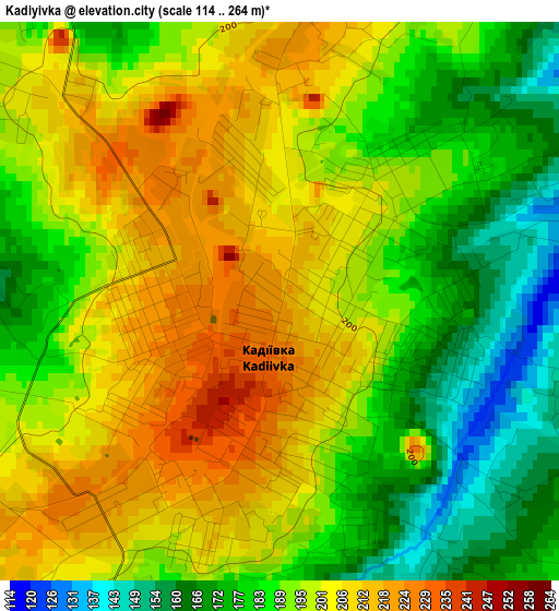
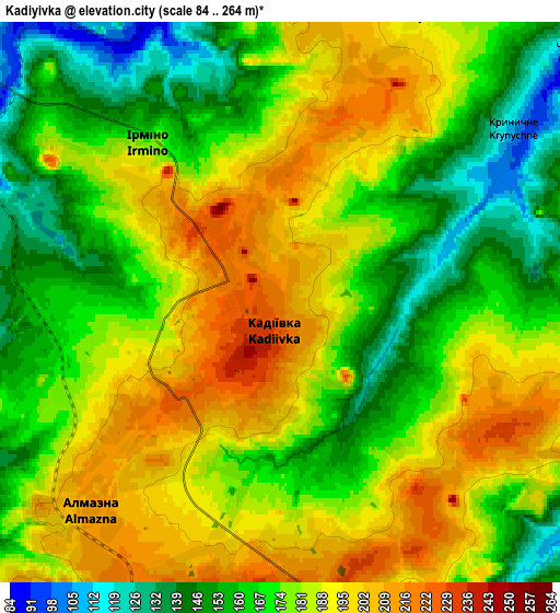
Below is the Elevation map of Kadiyivka, which displays elevation range with different colors. Scale of the first map is from 114 to 264 m (374 to 866 ft) with average elevation of 193.2 meters (=634 ft) [note 1]
These maps also provides idea of topography and contour of this city, they are displayed at different zoom levels. More info about maps, scale and edge coordinates you can find below images.
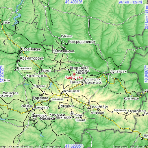
| \ | Map #1 | Map #2 | Topo.Map |
| Scale [m] | 114..264 m | 84..264 m | × |
| Scale [ft] | 374..866 ft | 276..866 ft | × |
| Average | 193.2 m = 634 ft | 176.9 m = 580 ft | × |
| Width | 6.47 km = 4 mi | 12.93 km = 8 mi | 206.9 km = 128.6 mi |
| Height | 6.47 km = 4 mi | 12.93 km = 8 mi | 206.9 km = 128.6 mi |
| ↑Max Latitude | 48.597251° | 48.626306° | 49.49019° |
| Latitude at center | 48.56818° | 48.56818° | 48.56818° |
| ↓Min Latitude | 48.539092° | 48.509987° | 47.62905° |
| ← Min Longitude | 38.599575° | 38.555629° | 37.23727° |
| Longitude center | 38.64352° | 38.64352° | 38.64352° |
| →Max Longitude | 38.687465° | 38.731411° | 40.04977° |
Nearby cities:
Cities around Kadiyivka sort by population:
• Alchevs’k elevation 211 m
16.9 km,  130°
130°
• Bryanka 219 m
6.7 km,  161°
161°
• Pervomays’k 154 m
9.8 km,  314°
314°
• Kirovs’k 196 m
7.7 km,  359°
359°
• Pereval’s’k 227 m
20.7 km, 134°
• Popasna 243 m
20.8 km,  290°
290°
• Hirs’ke 207 m
21.5 km,  329°
329°
• Zymohiria 53 m
21.7 km,  84°
84°
• Artemivs’k 282 m
15.6 km, 155°
• Zoryns’k 265 m
17.4 km,  184°
184°
• Toshkivka 131 m
23.9 km,  348°
348°
• Bayrachky 262 m
19.8 km,  188°
188°
Multilingual:
 En español:
Stajánov elevación 217 m.
 En France:
Stakhanov, Kadiïvka élévation 217 m.
 Auf Deutsch:
Stachanow höhe über dem Meeresspiegel ist 217 m.
 На русском:
Kadiyevka, Стаханов высота над уровнем моря 217 м
Sources and notes:
- [note 1] Map square and city borders are not equal. Map elevation data is calculated only from area inside that square.
- [src 1] Elevation data from geonames database provided with same terms of usage.
- [src 2] The elevation map of Kadiyivka is generated using elevation data from NASA's 3 arcsec (90m) resolution SRTM data.
- [src 3] Base (background) map © OpenStreetMap contributors tiles are generated by Geofabrik and OpenTopoMap.
Copyright & License:
This Kadiyivka Elevation Map is licensed under CC BY-SA. You may reuse any part from this page, if you give a proper credit by linking to this URL:
 More info on terms of use page.