Toshkivka elevation
Toshkivka (Luhansk), Ukraine elevation is 131 meters and Toshkivka elevation in feet is 430 ft above sea level [src 1]. Toshkivka is a populated place (feature code) with elevation that is 26 meters (85 ft) smaller than average city elevation in Ukraine.
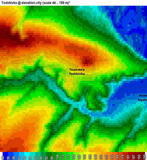
Below is the Elevation map of Toshkivka, which displays elevation range with different colors. Scale of the first map is from 44 to 199 m (144 to 653 ft) with average elevation of 115.5 meters (=379 ft) [note 1]
These maps also provides idea of topography and contour of this city, they are displayed at different zoom levels. More info about maps, scale and edge coordinates you can find below images.
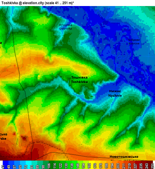
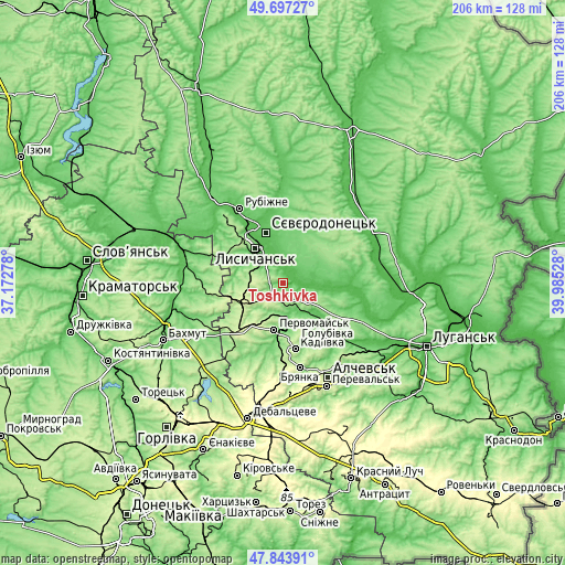
| \ | Map #1 | Map #2 | Topo.Map |
| Scale [m] | 44..199 m | 41..251 m | × |
| Scale [ft] | 144..653 ft | 135..823 ft | × |
| Average | 115.5 m = 379 ft | 121.3 m = 398 ft | × |
| Width | 6.44 km = 4 mi | 12.88 km = 8 mi | 206.1 km = 128.1 mi |
| Height | 6.44 km = 4 mi | 12.88 km = 8 mi | 206.1 km = 128.1 mi |
| ↑Max Latitude | 48.80809° | 48.837023° | 49.69727° |
| Latitude at center | 48.77914° | 48.77914° | 48.77914° |
| ↓Min Latitude | 48.750173° | 48.72119° | 47.84391° |
| ← Min Longitude | 38.535085° | 38.491139° | 37.17278° |
| Longitude center | 38.57903° | 38.57903° | 38.57903° |
| →Max Longitude | 38.622975° | 38.666921° | 39.98528° |
Nearby cities:
Cities around Toshkivka sort by population:
• Syevyerodonets’k elevation 74 m
19.9 km,  341°
341°
• Lysychans’k 183 m
17.2 km,  324°
324°
• Kadiyivka 217 m
23.9 km,  168°
168°
• Rubizhne 73 m
29.7 km,  330°
330°
• Bryanka 219 m
30.6 km, 167°
• Pervomays’k 154 m
16.8 km,  187°
187°
• Kirovs’k 196 m
16.4 km,  163°
163°
• Popasna 243 m
21.9 km,  222°
222°
• Hirs’ke 207 m
7.9 km,  231°
231°
• Slov`yanoserbsk 68 m
30.9 km,  107°
107°
• Tr’okhizbenka 49 m
28.3 km,  94°
94°
• Bilohorivka 70 m
29.1 km,  303°
303°
Multilingual:
 En español:
Toshkivka elevación 131 m.
 En France:
Toshkivka élévation 131 m.
 Auf Deutsch:
Toshkivka höhe über dem Meeresspiegel ist 131 m.

Sources and notes:
- [note 1] Map square and city borders are not equal. Map elevation data is calculated only from area inside that square.
- [src 1] Elevation data from geonames database provided with same terms of usage.
- [src 2] The elevation map of Toshkivka is generated using elevation data from NASA's 3 arcsec (90m) resolution SRTM data.
- [src 3] Base (background) map © OpenStreetMap contributors tiles are generated by Geofabrik and OpenTopoMap.
Copyright & License:
This Toshkivka Elevation Map is licensed under CC BY-SA. You may reuse any part from this page, if you give a proper credit by linking to this URL:
 More info on terms of use page.