Artemivs’k elevation
Artemivs’k (Luhansk), Ukraine elevation is 282 meters and Artemivs’k elevation in feet is 925 ft above sea level [src 1]. Artemivs’k is a populated place (feature code) with elevation that is 125 meters (410 ft) bigger than average city elevation in Ukraine.
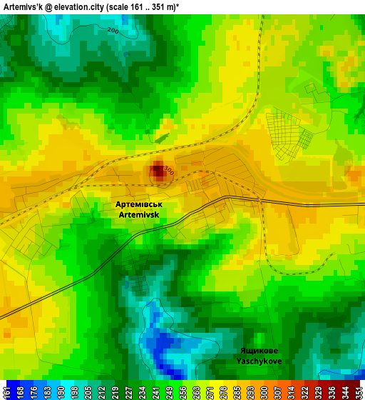
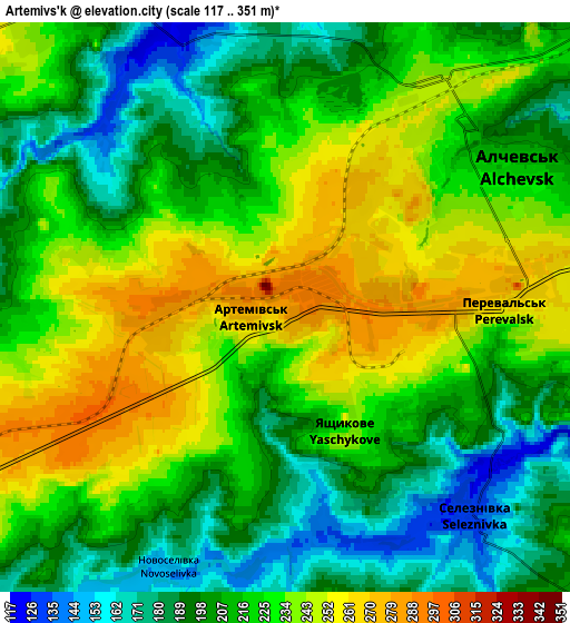
Below is the Elevation map of Artemivs’k, which displays elevation range with different colors. Scale of the first map is from 161 to 351 m (528 to 1152 ft) with average elevation of 253.1 meters (=830 ft) [note 1]
These maps also provides idea of topography and contour of this city, they are displayed at different zoom levels. More info about maps, scale and edge coordinates you can find below images.
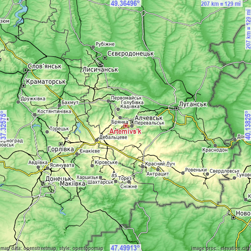
| \ | Map #1 | Map #2 | Topo.Map |
| Scale [m] | 161..351 m | 117..351 m | × |
| Scale [ft] | 528..1152 ft | 384..1152 ft | × |
| Average | 253.1 m = 830 ft | 217.9 m = 715 ft | × |
| Width | 6.48 km = 4 mi | 12.97 km = 8.1 mi | 207.5 km = 128.9 mi |
| Height | 6.48 km = 4 mi | 12.97 km = 8.1 mi | 207.4 km = 128.9 mi |
| ↑Max Latitude | 48.469755° | 48.498883° | 49.36496° |
| Latitude at center | 48.44061° | 48.44061° | 48.44061° |
| ↓Min Latitude | 48.411448° | 48.38227° | 47.49913° |
| ← Min Longitude | 38.688055° | 38.644109° | 37.32575° |
| Longitude center | 38.732° | 38.732° | 38.732° |
| →Max Longitude | 38.775945° | 38.819891° | 40.13825° |
Nearby cities:
Cities around Artemivs’k sort by population:
• Alchevs’k elevation 211 m
7 km,  63°
63°
• Kadiyivka 217 m
15.6 km,  335°
335°
• Bryanka 219 m
9 km,  330°
330°
• Pervomays’k 154 m
25 km, 327°
• Kirovs’k 196 m
22.9 km, 343°
• Debal’tseve 323 m
26.6 km,  245°
245°
• Pereval’s’k 227 m
8.3 km,  92°
92°
• Zymohiria 53 m
22.1 km,  43°
43°
• Chornukhyne 311 m
20.2 km,  229°
229°
• Zoryns’k 265 m
8.6 km, 248°
• Bile 68 m
24.3 km,  75°
75°
• Bayrachky 262 m
11 km,  240°
240°
Multilingual:
 En español:
Artemivs’k elevación 282 m.
 En France:
Artemivs’k élévation 282 m.
 Auf Deutsch:
Artemivs’k höhe über dem Meeresspiegel ist 282 m.

Sources and notes:
- [note 1] Map square and city borders are not equal. Map elevation data is calculated only from area inside that square.
- [src 1] Elevation data from geonames database provided with same terms of usage.
- [src 2] The elevation map of Artemivs’k is generated using elevation data from NASA's 3 arcsec (90m) resolution SRTM data.
- [src 3] Base (background) map © OpenStreetMap contributors tiles are generated by Geofabrik and OpenTopoMap.
Copyright & License:
This Artemivs’k Elevation Map is licensed under CC BY-SA. You may reuse any part from this page, if you give a proper credit by linking to this URL:
 More info on terms of use page.