Liuli elevation
Liuli (Ruvuma), Tanzania elevation is 476 meters and Liuli elevation in feet is 1562 ft above sea level [src 1]. Liuli is a populated place (feature code) with elevation that is 467 meters (1532 ft) smaller than average city elevation in Tanzania.
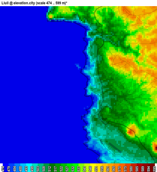
Below is the Elevation map of Liuli, which displays elevation range with different colors. Scale of the first map is from 474 to 599 m (1555 to 1965 ft) with average elevation of 499.1 meters (=1637 ft) [note 1]
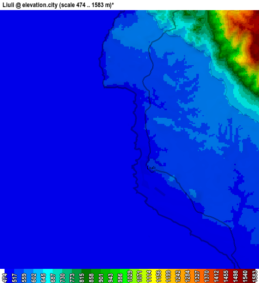
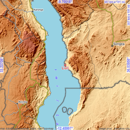
These maps also provides idea of topography and contour of this city, they are displayed at different zoom levels. More info about maps, scale and edge coordinates you can find below images.
| \ | Map #1 | Map #2 | Topo.Map |
| Scale [m] | 474..599 m | 474..1583 m | × |
| Scale [ft] | 1555..1965 ft | 1555..5194 ft | × |
| Average | 499.1 m = 1637 ft | 539 m = 1768 ft | × |
| Width | 9.59 km = 6 mi | 19.18 km = 11.9 mi | 306.9 km = 190.7 mi |
| Height | 9.59 km = 6 mi | 19.18 km = 11.9 mi | 306.9 km = 190.7 mi |
| ↑Max Latitude | -11.040201° | -10.997066° | -9.70018° |
| Latitude at center | -11.08333° | -11.08333° | -11.08333° |
| ↓Min Latitude | -11.126452° | -11.169569° | -12.45997° |
| ← Min Longitude | 34.589385° | 34.545439° | 33.22708° |
| Longitude center | 34.63333° | 34.63333° | 34.63333° |
| →Max Longitude | 34.677275° | 34.721221° | 36.03958° |
Nearby cities:
Cities around Liuli sort by population:
• Songea elevation 1113 m
119.6 km,  68°
68°
• Kyela 498 m
187.5 km,  332°
332°
• Mbinga 1357 m
45 km, 68°
• Kigonsera 1327 m
55.3 km,  55°
55°
• Maposeni 978 m
100.5 km, 56°
• Matiri 1324 m
47.1 km,  38°
38°
• Tingi 1203 m
49.8 km,  118°
118°
• Mlangali 1739 m
145.1 km,  354°
354°
• Mahanje 991 m
149 km,  30°
30°
• Mbamba Bay 476 m
26.6 km,  146°
146°
• Manda 476 m
68.8 km,  355°
355°
• Mwaya 479 m
186.2 km,  336°
336°
Multilingual:
 En español:
Liuli elevación 476 m.
 En France:
Liuli élévation 476 m.


Sources and notes:
- [note 1] Map square and city borders are not equal. Map elevation data is calculated only from area inside that square.
- [src 1] Elevation data from geonames database provided with same terms of usage.
- [src 2] The elevation map of Liuli is generated using elevation data from NASA's 3 arcsec (90m) resolution SRTM data.
- [src 3] Base (background) map © OpenStreetMap contributors tiles are generated by Geofabrik and OpenTopoMap.
Copyright & License:
This Liuli Elevation Map is licensed under CC BY-SA. You may reuse any part from this page, if you give a proper credit by linking to this URL:
 More info on terms of use page.