Songea elevation
Songea (Ruvuma, Songea Municipal), Tanzania elevation is 1113 meters and Songea elevation in feet is 3652 ft above sea level [src 1]. Songea is a seat of a first-order administrative division (feature code) with elevation that is 170 meters (558 ft) bigger than average city elevation in Tanzania.
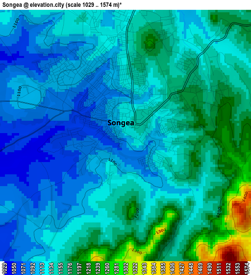
Below is the Elevation map of Songea, which displays elevation range with different colors. Scale of the first map is from 1029 to 1574 m (3376 to 5164 ft) with average elevation of 1138.5 meters (=3735 ft) [note 1]
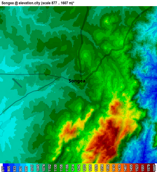
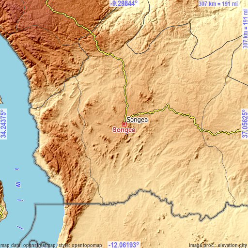
These maps also provides idea of topography and contour of this city, they are displayed at different zoom levels. More info about maps, scale and edge coordinates you can find below images.
| \ | Map #1 | Map #2 | Topo.Map |
| Scale [m] | 1029..1574 m | 877..1607 m | × |
| Scale [ft] | 3376..5164 ft | 2877..5272 ft | × |
| Average | 1138.5 m = 3735 ft | 1119.8 m = 3674 ft | × |
| Width | 9.6 km = 6 mi | 19.21 km = 11.9 mi | 307.3 km = 190.9 mi |
| Height | 9.6 km = 6 mi | 19.21 km = 11.9 mi | 307.3 km = 190.9 mi |
| ↑Max Latitude | -10.640143° | -10.596951° | -9.29844° |
| Latitude at center | -10.68333° | -10.68333° | -10.68333° |
| ↓Min Latitude | -10.726511° | -10.769685° | -12.06193° |
| ← Min Longitude | 35.606055° | 35.562109° | 34.24375° |
| Longitude center | 35.65° | 35.65° | 35.65° |
| →Max Longitude | 35.693945° | 35.737891° | 37.05625° |
Nearby cities:
Cities around Songea sort by population:
• Njombe elevation 1676 m
176.8 km,  327°
327°
• Malinyi 295 m
201.7 km,  15°
15°
• Mbinga 1357 m
74.5 km,  248°
248°
• Kigonsera 1327 m
66.8 km,  258°
258°
• Maposeni 978 m
29.5 km,  292°
292°
• Matiri 1324 m
82.3 km, 264°
• Tingi 1203 m
96.1 km,  224°
224°
• Mlangali 1739 m
159.3 km,  308°
308°
• Mahanje 991 m
90.3 km,  337°
337°
• Liuli 476 m
119.6 km, 248°
• Mbamba Bay 476 m
117.2 km,  235°
235°
• Manda 476 m
119.1 km,  281°
281°
Multilingual:
 En español:
Songea elevación 1113 m.
 En France:
Songea élévation 1113 m.


Sources and notes:
- [note 1] Map square and city borders are not equal. Map elevation data is calculated only from area inside that square.
- [src 1] Elevation data from geonames database provided with same terms of usage.
- [src 2] The elevation map of Songea is generated using elevation data from NASA's 3 arcsec (90m) resolution SRTM data.
- [src 3] Base (background) map © OpenStreetMap contributors tiles are generated by Geofabrik and OpenTopoMap.
Copyright & License:
This Songea Elevation Map is licensed under CC BY-SA. You may reuse any part from this page, if you give a proper credit by linking to this URL:
 More info on terms of use page.