Mlangali elevation
Mlangali (Njombe, Ludewa), Tanzania elevation is 1739 meters and Mlangali elevation in feet is 5705 ft above sea level [src 1]. Mlangali is a populated place (feature code) with elevation that is 796 meters (2612 ft) bigger than average city elevation in Tanzania.
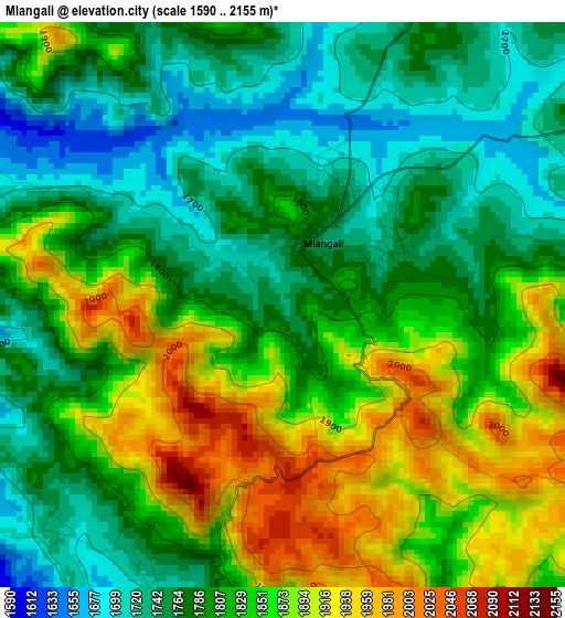
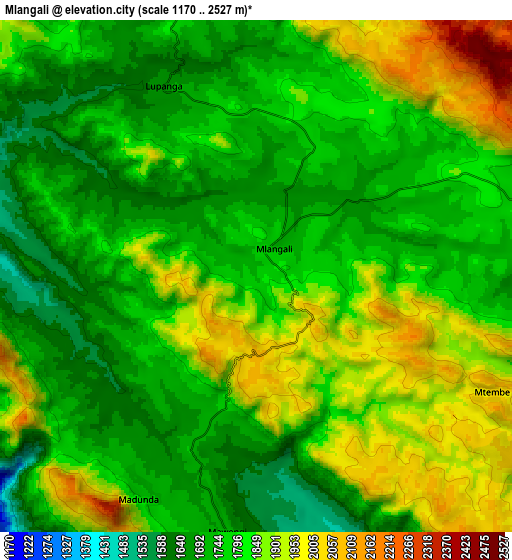
Below is the Elevation map of Mlangali, which displays elevation range with different colors. Scale of the first map is from 1590 to 2155 m (5217 to 7070 ft) with average elevation of 1816.8 meters (=5961 ft) [note 1]
These maps also provides idea of topography and contour of this city, they are displayed at different zoom levels. More info about maps, scale and edge coordinates you can find below images.
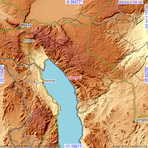
| \ | Map #1 | Map #2 | Topo.Map |
| Scale [m] | 1590..2155 m | 1170..2527 m | × |
| Scale [ft] | 5217..7070 ft | 3839..8291 ft | × |
| Average | 1816.8 m = 5961 ft | 1802.5 m = 5914 ft | × |
| Width | 9.63 km = 6 mi | 19.26 km = 12 mi | 308.1 km = 191.4 mi |
| Height | 9.63 km = 6 mi | 19.26 km = 12 mi | 308.2 km = 191.5 mi |
| ↑Max Latitude | -9.740021° | -9.696706° | -8.39477° |
| Latitude at center | -9.78333° | -9.78333° | -9.78333° |
| ↓Min Latitude | -9.826633° | -9.869931° | -11.16611° |
| ← Min Longitude | 34.472725° | 34.428779° | 33.11042° |
| Longitude center | 34.51667° | 34.51667° | 34.51667° |
| →Max Longitude | 34.560615° | 34.604561° | 35.92292° |
Nearby cities:
Cities around Mlangali sort by population:
• Makumbako elevation 1651 m
109.4 km,  18°
18°
• Njombe 1676 m
55.8 km,  30°
30°
• Kyela 498 m
76.4 km,  286°
286°
• Mtwango 1767 m
90.7 km, 20°
• Ilembula 1425 m
98.5 km,  4°
4°
• Ipinda 490 m
75.4 km,  296°
296°
• Mahanje 991 m
91 km,  100°
100°
• Masoko 887 m
97.8 km, 300°
• Matamba 2088 m
107.5 km,  325°
325°
• Kandete 1578 m
105.5 km,  311°
311°
• Manda 476 m
76.3 km,  174°
174°
• Mwaya 479 m
67.3 km, 292°
Multilingual:
 En español:
Mlangali elevación 1739 m.
 En France:
Mlangali élévation 1739 m.
 Auf Deutsch:
Mlangali höhe über dem Meeresspiegel ist 1739 m.

Sources and notes:
- [note 1] Map square and city borders are not equal. Map elevation data is calculated only from area inside that square.
- [src 1] Elevation data from geonames database provided with same terms of usage.
- [src 2] The elevation map of Mlangali is generated using elevation data from NASA's 3 arcsec (90m) resolution SRTM data.
- [src 3] Base (background) map © OpenStreetMap contributors tiles are generated by Geofabrik and OpenTopoMap.
Copyright & License:
This Mlangali Elevation Map is licensed under CC BY-SA. You may reuse any part from this page, if you give a proper credit by linking to this URL:
 More info on terms of use page.