Kyaka elevation
Kyaka (Kagera, Missenyi), Tanzania elevation is 1160 meters and Kyaka elevation in feet is 3806 ft above sea level [src 1]. Kyaka is a populated place (feature code) with elevation that is 217 meters (712 ft) bigger than average city elevation in Tanzania.
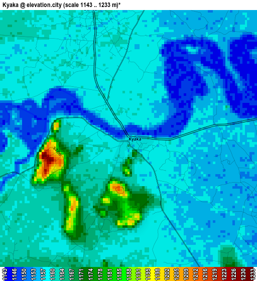
Below is the Elevation map of Kyaka, which displays elevation range with different colors. Scale of the first map is from 1143 to 1233 m (3750 to 4045 ft) with average elevation of 1158.8 meters (=3802 ft) [note 1]
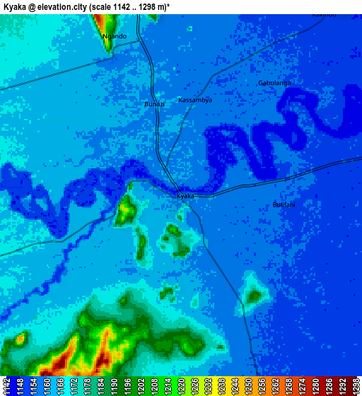
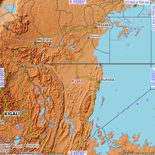
These maps also provides idea of topography and contour of this city, they are displayed at different zoom levels. More info about maps, scale and edge coordinates you can find below images.
| \ | Map #1 | Map #2 | Topo.Map |
| Scale [m] | 1143..1233 m | 1142..1298 m | × |
| Scale [ft] | 3750..4045 ft | 3747..4259 ft | × |
| Average | 1158.8 m = 3802 ft | 1161.6 m = 3811 ft | × |
| Width | 9.77 km = 6.1 mi | 19.54 km = 12.1 mi | 312.6 km = 194.2 mi |
| Height | 9.77 km = 6.1 mi | 19.54 km = 12.1 mi | 312.6 km = 194.2 mi |
| ↑Max Latitude | -1.208285° | -1.164349° | 0.15393° |
| Latitude at center | -1.25222° | -1.25222° | -1.25222° |
| ↓Min Latitude | -1.296154° | -1.340088° | -2.65762° |
| ← Min Longitude | 31.376335° | 31.332389° | 30.01403° |
| Longitude center | 31.42028° | 31.42028° | 31.42028° |
| →Max Longitude | 31.464225° | 31.508171° | 32.82653° |
Nearby cities:
Cities around Kyaka sort by population:
• Bukoba elevation 1149 m
44.5 km,  101°
101°
• Biharamulo 1479 m
153.9 km,  184°
184°
• Chato 1150 m
158.8 km,  165°
165°
• Nsunga 1202 m
12.4 km,  346°
346°
• Nshamba 1540 m
62.4 km, 166°
• Katerero 1164 m
38.5 km,  115°
115°
• Ngara 1814 m
163.8 km,  211°
211°
• Kamachumu 1496 m
46.4 km,  151°
151°
• Nyakahanga 1662 m
49.9 km,  218°
218°
• Katoro 1169 m
18.7 km, 151°
• Muleba 1270 m
70.3 km,  158°
158°
• Bugene 1639 m
48.9 km, 219°
Multilingual:
 En español:
Kyaka elevación 1160 m.
 En France:
Kyaka élévation 1160 m.


Sources and notes:
- [note 1] Map square and city borders are not equal. Map elevation data is calculated only from area inside that square.
- [src 1] Elevation data from geonames database provided with same terms of usage.
- [src 2] The elevation map of Kyaka is generated using elevation data from NASA's 3 arcsec (90m) resolution SRTM data.
- [src 3] Base (background) map © OpenStreetMap contributors tiles are generated by Geofabrik and OpenTopoMap.
Copyright & License:
This Kyaka Elevation Map is licensed under CC BY-SA. You may reuse any part from this page, if you give a proper credit by linking to this URL:
 More info on terms of use page.