Ngara elevation
Ngara (Kagera), Tanzania elevation is 1814 meters and Ngara elevation in feet is 5951 ft above sea level [src 1]. Ngara is a populated place (feature code) with elevation that is 871 meters (2858 ft) bigger than average city elevation in Tanzania.
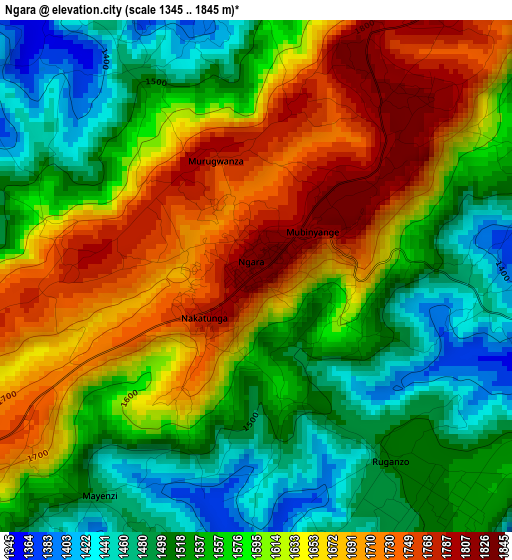
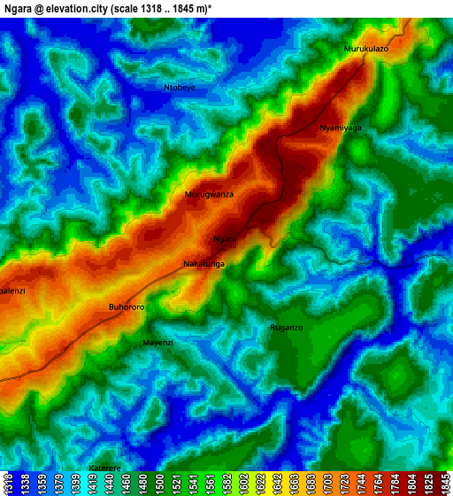
Below is the Elevation map of Ngara, which displays elevation range with different colors. Scale of the first map is from 1345 to 1845 m (4413 to 6053 ft) with average elevation of 1593.8 meters (=5229 ft) [note 1]
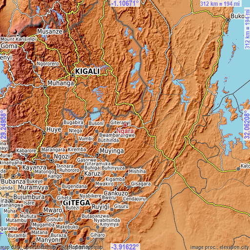
These maps also provides idea of topography and contour of this city, they are displayed at different zoom levels. More info about maps, scale and edge coordinates you can find below images.
| \ | Map #1 | Map #2 | Topo.Map |
| Scale [m] | 1345..1845 m | 1318..1845 m | × |
| Scale [ft] | 4413..6053 ft | 4324..6053 ft | × |
| Average | 1593.8 m = 5229 ft | 1494.3 m = 4903 ft | × |
| Width | 9.76 km = 6.1 mi | 19.53 km = 12.1 mi | 312.4 km = 194.1 mi |
| Height | 9.76 km = 6.1 mi | 19.53 km = 12.1 mi | 312.4 km = 194.1 mi |
| ↑Max Latitude | -2.468316° | -2.424411° | -1.10671° |
| Latitude at center | -2.51222° | -2.51222° | -2.51222° |
| ↓Min Latitude | -2.556122° | -2.600023° | -3.91622° |
| ← Min Longitude | 30.611885° | 30.567939° | 29.24958° |
| Longitude center | 30.65583° | 30.65583° | 30.65583° |
| →Max Longitude | 30.699775° | 30.743721° | 32.06208° |
Nearby cities:
Cities around Ngara sort by population:
• Uyovu elevation 1235 m
129.2 km,  131°
131°
• Biharamulo 1479 m
73.8 km,  100°
100°
• Bugarama 1493 m
42.3 km,  199°
199°
• Kibondo 1505 m
119.7 km,  176°
176°
• Chato 1150 m
124.2 km, 96°
• Kakonko 1245 m
92.3 km,  158°
158°
• Rulenge 1422 m
23 km,  186°
186°
• Nshamba 1540 m
127.3 km,  51°
51°
• Kabanga 1608 m
25.2 km,  236°
236°
• Nyakahanga 1662 m
114.6 km,  28°
28°
• Mabamba 1297 m
122 km, 188°
• Bugene 1639 m
115.7 km, 27°
Multilingual:
 En español:
Ngara elevación 1814 m.
 En France:
Ngara élévation 1814 m.


Sources and notes:
- [note 1] Map square and city borders are not equal. Map elevation data is calculated only from area inside that square.
- [src 1] Elevation data from geonames database provided with same terms of usage.
- [src 2] The elevation map of Ngara is generated using elevation data from NASA's 3 arcsec (90m) resolution SRTM data.
- [src 3] Base (background) map © OpenStreetMap contributors tiles are generated by Geofabrik and OpenTopoMap.
Copyright & License:
This Ngara Elevation Map is licensed under CC BY-SA. You may reuse any part from this page, if you give a proper credit by linking to this URL:
 More info on terms of use page.