Chato elevation
Chato (Geita, Chato District), Tanzania elevation is 1150 meters and Chato elevation in feet is 3773 ft above sea level [src 1]. Chato is a populated place (feature code) with elevation that is 207 meters (679 ft) bigger than average city elevation in Tanzania.
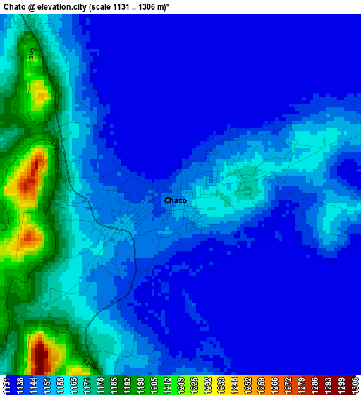
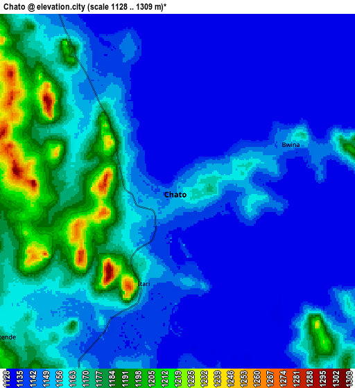
Below is the Elevation map of Chato, which displays elevation range with different colors. Scale of the first map is from 1131 to 1306 m (3711 to 4285 ft) with average elevation of 1152.7 meters (=3782 ft) [note 1]
These maps also provides idea of topography and contour of this city, they are displayed at different zoom levels. More info about maps, scale and edge coordinates you can find below images.
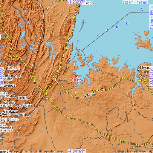
| \ | Map #1 | Map #2 | Topo.Map |
| Scale [m] | 1131..1306 m | 1128..1309 m | × |
| Scale [ft] | 3711..4285 ft | 3701..4295 ft | × |
| Average | 1152.7 m = 3782 ft | 1154.7 m = 3788 ft | × |
| Width | 9.76 km = 6.1 mi | 19.52 km = 12.1 mi | 312.4 km = 194.1 mi |
| Height | 9.76 km = 6.1 mi | 19.52 km = 12.1 mi | 312.4 km = 194.1 mi |
| ↑Max Latitude | -2.59388° | -2.549979° | -1.23237° |
| Latitude at center | -2.63778° | -2.63778° | -2.63778° |
| ↓Min Latitude | -2.681678° | -2.725574° | -4.04161° |
| ← Min Longitude | 31.722995° | 31.679049° | 30.36069° |
| Longitude center | 31.76694° | 31.76694° | 31.76694° |
| →Max Longitude | 31.810885° | 31.854831° | 33.17319° |
Nearby cities:
Cities around Chato sort by population:
• Ushirombo elevation 1186 m
97.5 km,  167°
167°
• Uyovu 1235 m
76.6 km,  200°
200°
• Buseresere 1247 m
44.5 km,  164°
164°
• Katoro 1297 m
44.9 km, 161°
• Geita 1416 m
57.9 km,  116°
116°
• Masumbwe 1191 m
120 km, 157°
• Biharamulo 1479 m
50.9 km,  270°
270°
• Kasamwa 1199 m
77.7 km,  107°
107°
• Kakonko 1245 m
114.4 km,  231°
231°
• Nshamba 1540 m
96.4 km,  345°
345°
• Kamachumu 1496 m
114.5 km, 351°
• Muleba 1270 m
89.6 km, 351°
Multilingual:
 En español:
Chato elevación 1150 m.
 En France:
Chato élévation 1150 m.


Sources and notes:
- [note 1] Map square and city borders are not equal. Map elevation data is calculated only from area inside that square.
- [src 1] Elevation data from geonames database provided with same terms of usage.
- [src 2] The elevation map of Chato is generated using elevation data from NASA's 3 arcsec (90m) resolution SRTM data.
- [src 3] Base (background) map © OpenStreetMap contributors tiles are generated by Geofabrik and OpenTopoMap.
Copyright & License:
This Chato Elevation Map is licensed under CC BY-SA. You may reuse any part from this page, if you give a proper credit by linking to this URL:
 More info on terms of use page.