Kasamwa elevation
Kasamwa (Geita), Tanzania elevation is 1199 meters and Kasamwa elevation in feet is 3934 ft above sea level [src 1]. Kasamwa is a populated place (feature code) with elevation that is 256 meters (840 ft) bigger than average city elevation in Tanzania.
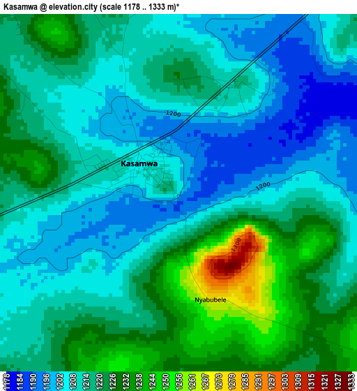
Below is the Elevation map of Kasamwa, which displays elevation range with different colors. Scale of the first map is from 1178 to 1333 m (3865 to 4373 ft) with average elevation of 1215.3 meters (=3987 ft) [note 1]
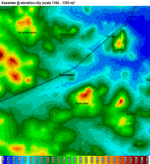
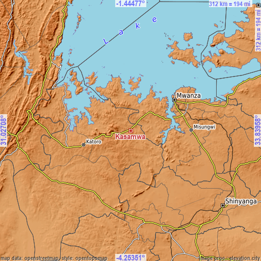
These maps also provides idea of topography and contour of this city, they are displayed at different zoom levels. More info about maps, scale and edge coordinates you can find below images.
| \ | Map #1 | Map #2 | Topo.Map |
| Scale [m] | 1178..1333 m | 1164..1353 m | × |
| Scale [ft] | 3865..4373 ft | 3819..4439 ft | × |
| Average | 1215.3 m = 3987 ft | 1220.6 m = 4005 ft | × |
| Width | 9.76 km = 6.1 mi | 19.52 km = 12.1 mi | 312.3 km = 194.1 mi |
| Height | 9.76 km = 6.1 mi | 19.52 km = 12.1 mi | 312.3 km = 194.1 mi |
| ↑Max Latitude | -2.806108° | -2.762215° | -1.44477° |
| Latitude at center | -2.85° | -2.85° | -2.85° |
| ↓Min Latitude | -2.89389° | -2.937779° | -4.25351° |
| ← Min Longitude | 32.389385° | 32.345439° | 31.02708° |
| Longitude center | 32.43333° | 32.43333° | 32.43333° |
| →Max Longitude | 32.477275° | 32.521221° | 33.83958° |
Nearby cities:
Cities around Kasamwa sort by population:
• Mwanza elevation 1144 m
63.7 km,  54°
54°
• Ushirombo 1186 m
88.4 km,  216°
216°
• Buseresere 1247 m
65 km,  252°
252°
• Katoro 1297 m
62.6 km, 252°
• Geita 1416 m
22.4 km,  263°
263°
• Misungwi 1178 m
72.2 km,  90°
90°
• Masumbwe 1191 m
91.4 km,  197°
197°
• Chato 1150 m
77.7 km,  287°
287°
• Mhango 1217 m
66.8 km,  136°
136°
• Usagara 1294 m
65.6 km,  73°
73°
• Misasi 1151 m
74.1 km,  103°
103°
• Nyanguge 1177 m
91.5 km, 68°
Multilingual:
 En español:
Kasamwa elevación 1199 m.
 En France:
Kasamwa élévation 1199 m.
 Auf Deutsch:
Kasamwa höhe über dem Meeresspiegel ist 1199 m.

Sources and notes:
- [note 1] Map square and city borders are not equal. Map elevation data is calculated only from area inside that square.
- [src 1] Elevation data from geonames database provided with same terms of usage.
- [src 2] The elevation map of Kasamwa is generated using elevation data from NASA's 3 arcsec (90m) resolution SRTM data.
- [src 3] Base (background) map © OpenStreetMap contributors tiles are generated by Geofabrik and OpenTopoMap.
Copyright & License:
This Kasamwa Elevation Map is licensed under CC BY-SA. You may reuse any part from this page, if you give a proper credit by linking to this URL:
 More info on terms of use page.