Bukoba elevation
Bukoba (Kagera, Bukoba Municipal), Tanzania elevation is 1149 meters and Bukoba elevation in feet is 3770 ft above sea level [src 1]. Bukoba is a seat of a first-order administrative division (feature code) with elevation that is 206 meters (676 ft) bigger than average city elevation in Tanzania.
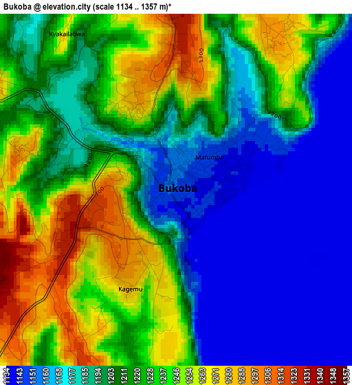
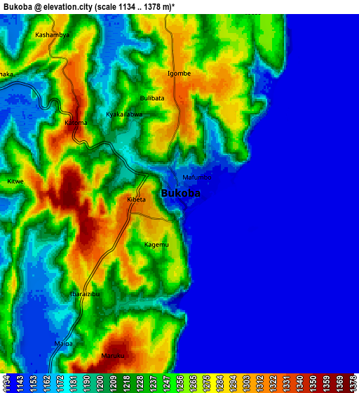
Below is the Elevation map of Bukoba, which displays elevation range with different colors. Scale of the first map is from 1134 to 1357 m (3720 to 4452 ft) with average elevation of 1208.3 meters (=3964 ft) [note 1]
These maps also provides idea of topography and contour of this city, they are displayed at different zoom levels. More info about maps, scale and edge coordinates you can find below images.
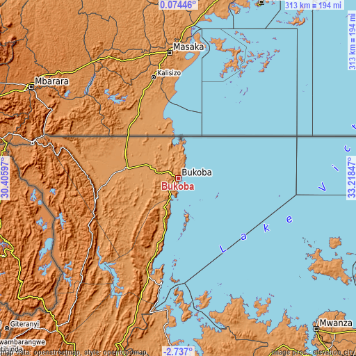
| \ | Map #1 | Map #2 | Topo.Map |
| Scale [m] | 1134..1357 m | 1134..1378 m | × |
| Scale [ft] | 3720..4452 ft | 3720..4521 ft | × |
| Average | 1208.3 m = 3964 ft | 1199.5 m = 3935 ft | × |
| Width | 9.77 km = 6.1 mi | 19.54 km = 12.1 mi | 312.6 km = 194.2 mi |
| Height | 9.77 km = 6.1 mi | 19.54 km = 12.1 mi | 312.6 km = 194.2 mi |
| ↑Max Latitude | -1.287736° | -1.243802° | 0.07446° |
| Latitude at center | -1.33167° | -1.33167° | -1.33167° |
| ↓Min Latitude | -1.375603° | -1.419535° | -2.737° |
| ← Min Longitude | 31.768275° | 31.724329° | 30.40597° |
| Longitude center | 31.81222° | 31.81222° | 31.81222° |
| →Max Longitude | 31.856165° | 31.900111° | 33.21847° |
Nearby cities:
Cities around Bukoba sort by population:
• Chato elevation 1150 m
145.3 km,  181°
181°
• Muriti 1141 m
142.5 km,  120°
120°
• Nsunga 1202 m
50.9 km,  294°
294°
• Nshamba 1540 m
59.5 km,  209°
209°
• Katerero 1164 m
11.6 km,  229°
229°
• Kamachumu 1496 m
38.4 km, 213°
• Nyakahanga 1662 m
80.5 km,  247°
247°
• Kyaka 1160 m
44.5 km,  281°
281°
• Katoro 1169 m
35.5 km,  257°
257°
• Muleba 1270 m
59.1 km,  197°
197°
• Bugene 1639 m
80.1 km, 248°
• Bukonyo 1146 m
142.3 km, 118°
Multilingual:
 En español:
Bukoba elevación 1149 m.
 En France:
Bukoba élévation 1149 m.


Sources and notes:
- [note 1] Map square and city borders are not equal. Map elevation data is calculated only from area inside that square.
- [src 1] Elevation data from geonames database provided with same terms of usage.
- [src 2] The elevation map of Bukoba is generated using elevation data from NASA's 3 arcsec (90m) resolution SRTM data.
- [src 3] Base (background) map © OpenStreetMap contributors tiles are generated by Geofabrik and OpenTopoMap.
Copyright & License:
This Bukoba Elevation Map is licensed under CC BY-SA. You may reuse any part from this page, if you give a proper credit by linking to this URL:
 More info on terms of use page.