Havsa elevation
Havsa (Edirne), Turkey elevation is 80 meters and Havsa elevation in feet is 262 ft above sea level [src 1]. Havsa is a seat of a second-order administrative division (feature code) with elevation that is 643 meters (2110 ft) smaller than average city elevation in Turkey.
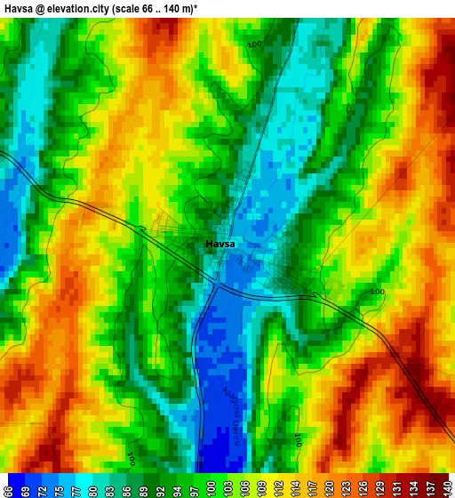
Below is the Elevation map of Havsa, which displays elevation range with different colors. Scale of the first map is from 66 to 140 m (217 to 459 ft) with average elevation of 101.8 meters (=334 ft) [note 1]
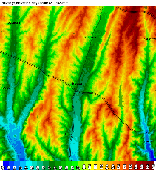
These maps also provides idea of topography and contour of this city, they are displayed at different zoom levels. More info about maps, scale and edge coordinates you can find below images.
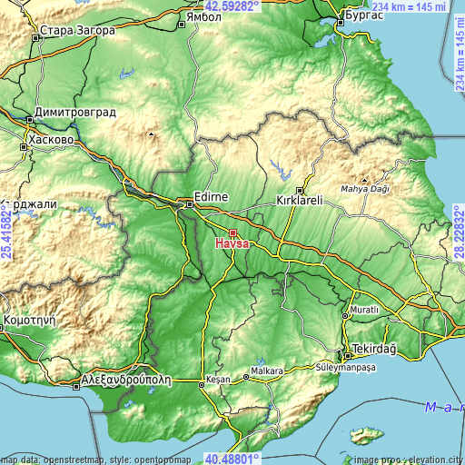
| \ | Map #1 | Map #2 | Topo.Map |
| Scale [m] | 66..140 m | 45..148 m | × |
| Scale [ft] | 217..459 ft | 148..486 ft | × |
| Average | 101.8 m = 334 ft | 100 m = 328 ft | × |
| Width | 7.31 km = 4.5 mi | 14.63 km = 9.1 mi | 234 km = 145.4 mi |
| Height | 7.31 km = 4.5 mi | 14.63 km = 9.1 mi | 234 km = 145.4 mi |
| ↑Max Latitude | 41.58186° | 41.614723° | 42.59282° |
| Latitude at center | 41.54898° | 41.54898° | 41.54898° |
| ↓Min Latitude | 41.516083° | 41.48317° | 40.48801° |
| ← Min Longitude | 26.778125° | 26.734179° | 25.41582° |
| Longitude center | 26.82207° | 26.82207° | 26.82207° |
| →Max Longitude | 26.866015° | 26.909961° | 28.22832° |
Nearby cities:
Cities around Havsa sort by population:
• Edirne elevation 62 m
26.3 km,  302°
302°
• Uzunköprü 34 m
33.4 km,  199°
199°
• Babaeski 58 m
26 km,  119°
119°
• Pehlivanköy 33 m
23.9 km,  158°
158°
• Lâlapaşa 162 m
33.1 km,  347°
347°
• Yoğuntaş 348 m
37.5 km,  33°
33°
• Çöpköy 79 m
36.6 km,  179°
179°
• Süloğlu 148 m
25.5 km,  16°
16°
• İnece 105 m
24.9 km,  55°
55°
• Kırcasalih 97 m
17.8 km,  187°
187°
• Karakasım 39 m
15.3 km,  256°
256°
• Hasköy 108 m
10.3 km, 16°
Multilingual:
 En español:
Havsa elevación 80 m.
 En France:
Havsa élévation 80 m.


Sources and notes:
- [note 1] Map square and city borders are not equal. Map elevation data is calculated only from area inside that square.
- [src 1] Elevation data from geonames database provided with same terms of usage.
- [src 2] The elevation map of Havsa is generated using elevation data from NASA's 3 arcsec (90m) resolution SRTM data.
- [src 3] Base (background) map © OpenStreetMap contributors tiles are generated by Geofabrik and OpenTopoMap.
Copyright & License:
This Havsa Elevation Map is licensed under CC BY-SA. You may reuse any part from this page, if you give a proper credit by linking to this URL:
 More info on terms of use page.