Uzunköprü elevation
Uzunköprü (Edirne), Turkey elevation is 34 meters and Uzunköprü elevation in feet is 112 ft above sea level [src 1]. Uzunköprü is a seat of a second-order administrative division (feature code) with elevation that is 689 meters (2260 ft) smaller than average city elevation in Turkey.
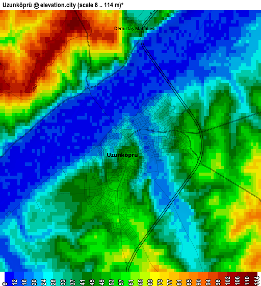
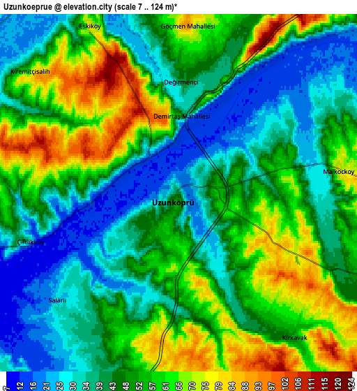
Below is the Elevation map of Uzunköprü, which displays elevation range with different colors. Scale of the first map is from 8 to 114 m (26 to 374 ft) with average elevation of 40.8 meters (=134 ft) [note 1]
These maps also provides idea of topography and contour of this city, they are displayed at different zoom levels. More info about maps, scale and edge coordinates you can find below images.
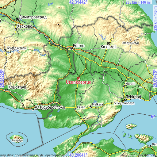
| \ | Map #1 | Map #2 | Topo.Map |
| Scale [m] | 8..114 m | 7..124 m | × |
| Scale [ft] | 26..374 ft | 23..407 ft | × |
| Average | 40.8 m = 134 ft | 48.5 m = 159 ft | × |
| Width | 7.35 km = 4.6 mi | 14.69 km = 9.1 mi | 235.1 km = 146.1 mi |
| Height | 7.35 km = 4.6 mi | 14.69 km = 9.1 mi | 235 km = 146 mi |
| ↑Max Latitude | 41.298993° | 41.332° | 42.31442° |
| Latitude at center | 41.26597° | 41.26597° | 41.26597° |
| ↓Min Latitude | 41.23293° | 41.199873° | 40.20041° |
| ← Min Longitude | 26.644555° | 26.600609° | 25.28225° |
| Longitude center | 26.6885° | 26.6885° | 26.6885° |
| →Max Longitude | 26.732445° | 26.776391° | 28.09475° |
Nearby cities:
Cities around Uzunköprü sort by population:
• Hayrabolu elevation 64 m
35.5 km,  99°
99°
• Havsa 80 m
33.4 km,  19°
19°
• Pehlivanköy 33 m
21.8 km,  65°
65°
• Meriç 40 m
23.8 km,  249°
249°
• Küplü 17 m
33.3 km,  237°
237°
• Susuzmüsellim 98 m
36.8 km,  120°
120°
• İbriktepe 120 m
32.4 km,  208°
208°
• Şahin 223 m
30.1 km,  154°
154°
• Karakasım 39 m
28.2 km,  352°
352°
• Kırcasalih 97 m
16.4 km,  32°
32°
• Hamidiye 99 m
12.9 km,  189°
189°
• Çöpköy 79 m
12.3 km,  114°
114°
Multilingual:
 En español:
Uzunköprü elevación 34 m.
 En France:
Uzunköprü élévation 34 m.
 Auf Deutsch:
Uzunköprü höhe über dem Meeresspiegel ist 34 m.
 На русском:
Узункепрю, Узункёпрю высота над уровнем моря 34 м
Sources and notes:
- [note 1] Map square and city borders are not equal. Map elevation data is calculated only from area inside that square.
- [src 1] Elevation data from geonames database provided with same terms of usage.
- [src 2] The elevation map of Uzunköprü is generated using elevation data from NASA's 3 arcsec (90m) resolution SRTM data.
- [src 3] Base (background) map © OpenStreetMap contributors tiles are generated by Geofabrik and OpenTopoMap.
Copyright & License:
This Uzunköprü Elevation Map is licensed under CC BY-SA. You may reuse any part from this page, if you give a proper credit by linking to this URL:
 More info on terms of use page.