Susuzmüsellim elevation
Susuzmüsellim (Tekirdağ), Turkey elevation is 98 meters and Susuzmüsellim elevation in feet is 322 ft above sea level [src 1]. Susuzmüsellim is a seat of a third-order administrative division (feature code) with elevation that is 625 meters (2051 ft) smaller than average city elevation in Turkey.
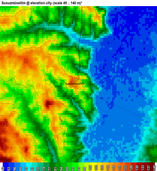
Below is the Elevation map of Susuzmüsellim, which displays elevation range with different colors. Scale of the first map is from 49 to 140 m (161 to 459 ft) with average elevation of 80.1 meters (=263 ft) [note 1]
These maps also provides idea of topography and contour of this city, they are displayed at different zoom levels. More info about maps, scale and edge coordinates you can find below images.
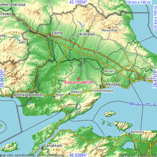
| \ | Map #1 | Topo.Map |
| Scale [m] | 49..140 m | × |
| Scale [ft] | 161..459 ft | × |
| Average | 80.1 m = 263 ft | × |
| Width | 7.36 km = 4.6 mi | 235.7 km = 146.5 mi |
| Height | 7.36 km = 4.6 mi | 235.6 km = 146.4 mi |
| ↑Max Latitude | 41.131998° | 42.15004° |
| Latitude at center | 41.09889° | 41.09889° |
| ↓Min Latitude | 41.065766° | 40.03064° |
| ← Min Longitude | 27.023555° | 25.66125° |
| Longitude center | 27.0675° | 27.0675° |
| →Max Longitude | 27.111445° | 28.47375° |
Nearby cities:
Cities around Susuzmüsellim sort by population:
• Uzunköprü elevation 34 m
36.8 km,  300°
300°
• Malkara 264 m
27.1 km,  211°
211°
• Hayrabolu 64 m
13.1 km,  14°
14°
• Pehlivanköy 33 m
30.2 km,  336°
336°
• Hamidiye 99 m
34.3 km,  279°
279°
• Ballı 147 m
29.9 km,  181°
181°
• İnecik 154 m
25.5 km,  135°
135°
• Çöpköy 79 m
24.5 km, 303°
• Banarlı 111 m
22.8 km,  98°
98°
• Şahin 223 m
20.7 km,  245°
245°
• Dambaslar 82 m
20.6 km,  47°
47°
• Yürük 197 m
18.2 km, 180°
Multilingual:
 En español:
Susuzmüsellim elevación 98 m.
 En France:
Susuzmüsellim élévation 98 m.
 Auf Deutsch:
Susuzmüsellim höhe über dem Meeresspiegel ist 98 m.

Sources and notes:
- [note 1] Map square and city borders are not equal. Map elevation data is calculated only from area inside that square.
- [src 1] Elevation data from geonames database provided with same terms of usage.
- [src 2] The elevation map of Susuzmüsellim is generated using elevation data from NASA's 3 arcsec (90m) resolution SRTM data.
- [src 3] Base (background) map © OpenStreetMap contributors tiles are generated by Geofabrik and OpenTopoMap.
Copyright & License:
This Susuzmüsellim Elevation Map is licensed under CC BY-SA. You may reuse any part from this page, if you give a proper credit by linking to this URL:
 More info on terms of use page.