Afşin elevation
Afşin (Kahramanmaraş), Turkey elevation is 1222 meters and Afşin elevation in feet is 4009 ft above sea level [src 1]. Afşin is a seat of a second-order administrative division (feature code) with elevation that is 499 meters (1637 ft) bigger than average city elevation in Turkey.
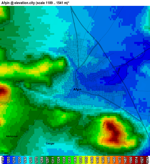
Below is the Elevation map of Afşin, which displays elevation range with different colors. Scale of the first map is from 1189 to 1541 m (3901 to 5056 ft) with average elevation of 1271.8 meters (=4173 ft) [note 1]
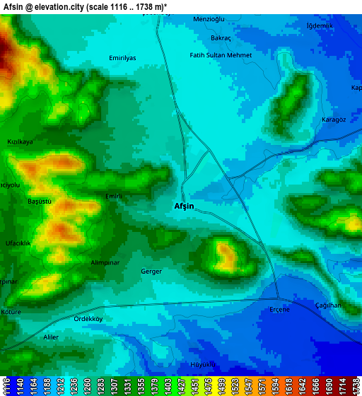
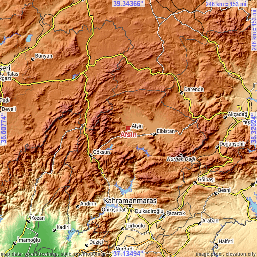
These maps also provides idea of topography and contour of this city, they are displayed at different zoom levels. More info about maps, scale and edge coordinates you can find below images.
| \ | Map #1 | Map #2 | Topo.Map |
| Scale [m] | 1189..1541 m | 1116..1738 m | × |
| Scale [ft] | 3901..5056 ft | 3661..5702 ft | × |
| Average | 1271.8 m = 4173 ft | 1268.1 m = 4160 ft | × |
| Width | 7.67 km = 4.8 mi | 15.35 km = 9.5 mi | 245.6 km = 152.6 mi |
| Height | 7.67 km = 4.8 mi | 15.35 km = 9.5 mi | 245.6 km = 152.6 mi |
| ↑Max Latitude | 38.282194° | 38.316681° | 39.34366° |
| Latitude at center | 38.24769° | 38.24769° | 38.24769° |
| ↓Min Latitude | 38.21317° | 38.178633° | 37.13494° |
| ← Min Longitude | 36.870045° | 36.826099° | 35.50774° |
| Longitude center | 36.91399° | 36.91399° | 36.91399° |
| →Max Longitude | 36.957935° | 37.001881° | 38.32024° |
Nearby cities:
Cities around Afşin sort by population:
• Elbistan elevation 1139 m
25.3 km,  100°
100°
• Göksun 1344 m
44.3 km,  235°
235°
• Gürün 1335 m
61.2 km,  30°
30°
• Nurhak 1384 m
55.8 km,  124°
124°
• Celeyke 1285 m
31.8 km,  131°
131°
• Tufanbeyli 1427 m
60.6 km,  271°
271°
• Sarız 1571 m
44.4 km,  305°
305°
• Ağabeyli 1018 m
59.8 km,  162°
162°
• Gücük 1474 m
49.9 km, 96°
• Süleymanlı 1137 m
42.6 km,  191°
191°
• Tanır 1239 m
19.1 km,  359°
359°
• Çardak 1399 m
19.1 km,  204°
204°
Multilingual:
 En español:
Afşin elevación 1222 m.
 En France:
Afşin élévation 1222 m.


Sources and notes:
- [note 1] Map square and city borders are not equal. Map elevation data is calculated only from area inside that square.
- [src 1] Elevation data from geonames database provided with same terms of usage.
- [src 2] The elevation map of Afşin is generated using elevation data from NASA's 3 arcsec (90m) resolution SRTM data.
- [src 3] Base (background) map © OpenStreetMap contributors tiles are generated by Geofabrik and OpenTopoMap.
Copyright & License:
This Afşin Elevation Map is licensed under CC BY-SA. You may reuse any part from this page, if you give a proper credit by linking to this URL:
 More info on terms of use page.