Gücük elevation
Gücük (Kahramanmaraş), Turkey elevation is 1474 meters and Gücük elevation in feet is 4836 ft above sea level [src 1]. Gücük is a seat of a third-order administrative division (feature code) with elevation that is 751 meters (2464 ft) bigger than average city elevation in Turkey.
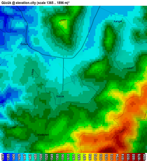
Below is the Elevation map of Gücük, which displays elevation range with different colors. Scale of the first map is from 1365 to 1896 m (4478 to 6220 ft) with average elevation of 1535.8 meters (=5039 ft) [note 1]
These maps also provides idea of topography and contour of this city, they are displayed at different zoom levels. More info about maps, scale and edge coordinates you can find below images.
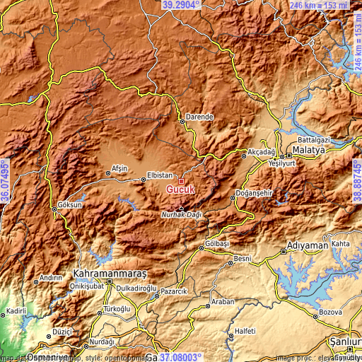
| \ | Map #1 | Topo.Map |
| Scale [m] | 1365..1896 m | × |
| Scale [ft] | 4478..6220 ft | × |
| Average | 1535.8 m = 5039 ft | × |
| Width | 7.68 km = 4.8 mi | 245.8 km = 152.7 mi |
| Height | 7.68 km = 4.8 mi | 245.8 km = 152.7 mi |
| ↑Max Latitude | 38.22813° | 39.2904° |
| Latitude at center | 38.1936° | 38.1936° |
| ↓Min Latitude | 38.159054° | 37.08003° |
| ← Min Longitude | 37.437255° | 36.07495° |
| Longitude center | 37.4812° | 37.4812° |
| →Max Longitude | 37.525145° | 38.88745° |
Nearby cities:
Cities around Gücük sort by population:
• Elbistan elevation 1139 m
24.8 km,  273°
273°
• Gölbaşı 898 m
47.6 km,  163°
163°
• Darende 1036 m
39.2 km,  3°
3°
• Doğanşehir 1248 m
36.1 km,  109°
109°
• Akçadağ 1067 m
45.6 km,  69°
69°
• Nurhak 1384 m
25.8 km,  187°
187°
• Celeyke 1285 m
29.7 km,  239°
239°
• Sürgü 1318 m
47.1 km,  116°
116°
• Harmanlı 1141 m
45.8 km,  149°
149°
• Levent 1356 m
42.3 km,  50°
50°
• Balaban 1093 m
30.9 km,  15°
15°
• Kürecik 1548 m
27.7 km, 54°
Multilingual:
 En español:
Gücük elevación 1474 m.
 En France:
Gücük élévation 1474 m.


Sources and notes:
- [note 1] Map square and city borders are not equal. Map elevation data is calculated only from area inside that square.
- [src 1] Elevation data from geonames database provided with same terms of usage.
- [src 2] The elevation map of Gücük is generated using elevation data from NASA's 3 arcsec (90m) resolution SRTM data.
- [src 3] Base (background) map © OpenStreetMap contributors tiles are generated by Geofabrik and OpenTopoMap.
Copyright & License:
This Gücük Elevation Map is licensed under CC BY-SA. You may reuse any part from this page, if you give a proper credit by linking to this URL:
 More info on terms of use page.