Darende elevation
Darende (Malatya), Turkey elevation is 1036 meters and Darende elevation in feet is 3399 ft above sea level [src 1]. Darende is a seat of a second-order administrative division (feature code) with elevation that is 313 meters (1027 ft) bigger than average city elevation in Turkey.
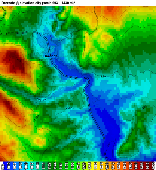
Below is the Elevation map of Darende, which displays elevation range with different colors. Scale of the first map is from 993 to 1430 m (3258 to 4692 ft) with average elevation of 1146 meters (=3760 ft) [note 1]
These maps also provides idea of topography and contour of this city, they are displayed at different zoom levels. More info about maps, scale and edge coordinates you can find below images.
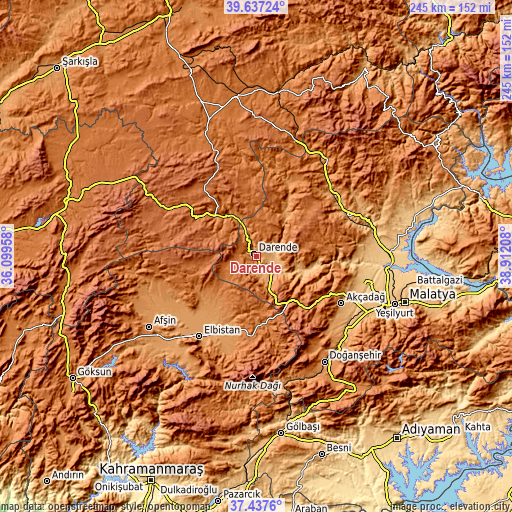
| \ | Map #1 | Map #2 | Topo.Map |
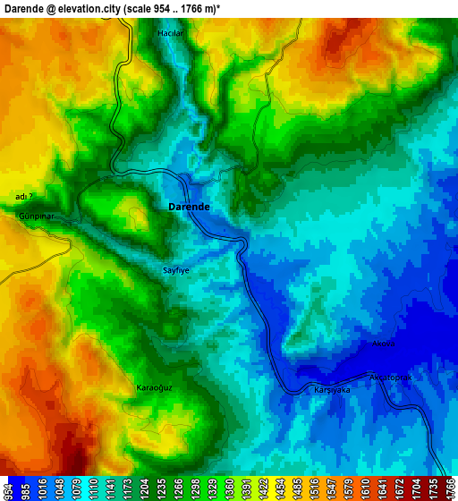
| Scale [m] | 993..1430 m | 954..1766 m | × |
| Scale [ft] | 3258..4692 ft | 3130..5794 ft | × |
| Average | 1146 m = 3760 ft | 1252.3 m = 4109 ft | × |
| Width | 7.64 km = 4.7 mi | 15.29 km = 9.5 mi | 244.6 km = 152 mi |
| Height | 7.64 km = 4.7 mi | 15.29 km = 9.5 mi | 244.6 km = 152 mi |
| ↑Max Latitude | 38.580192° | 38.614537° | 39.63724° |
| Latitude at center | 38.54583° | 38.54583° | 38.54583° |
| ↓Min Latitude | 38.511452° | 38.477057° | 37.4376° |
| ← Min Longitude | 37.461885° | 37.417939° | 36.09958° |
| Longitude center | 37.50583° | 37.50583° | 37.50583° |
| →Max Longitude | 37.549775° | 37.593721° | 38.91208° |
Nearby cities:
Cities around Darende sort by population:
• Elbistan elevation 1139 m
46.3 km,  215°
215°
• Akçadağ 1067 m
46.5 km,  119°
119°
• Hekimhan 1107 m
47.5 km,  50°
50°
• Gürün 1335 m
28.3 km,  313°
313°
• Kuluncak 1243 m
39.2 km,  20°
20°
• Tanır 1239 m
53.5 km,  254°
254°
• Konakpınar 1739 m
43.9 km,  335°
335°
• Gücük 1474 m
39.2 km,  183°
183°
• Levent 1356 m
32.6 km,  111°
111°
• Kurşunlu 1531 m
32.3 km,  68°
68°
• Kürecik 1548 m
31 km,  138°
138°
• Balaban 1093 m
11.4 km,  146°
146°
Multilingual:
 En español:
Darende elevación 1036 m.
 En France:
Darende élévation 1036 m.
 Auf Deutsch:
Darende höhe über dem Meeresspiegel ist 1036 m.

Sources and notes:
- [note 1] Map square and city borders are not equal. Map elevation data is calculated only from area inside that square.
- [src 1] Elevation data from geonames database provided with same terms of usage.
- [src 2] The elevation map of Darende is generated using elevation data from NASA's 3 arcsec (90m) resolution SRTM data.
- [src 3] Base (background) map © OpenStreetMap contributors tiles are generated by Geofabrik and OpenTopoMap.
Copyright & License:
This Darende Elevation Map is licensed under CC BY-SA. You may reuse any part from this page, if you give a proper credit by linking to this URL:
 More info on terms of use page.