Süleymanlı elevation
Süleymanlı (Kahramanmaraş), Turkey elevation is 1137 meters and Süleymanlı elevation in feet is 3730 ft above sea level [src 1]. Süleymanlı is a seat of a third-order administrative division (feature code) with elevation that is 414 meters (1358 ft) bigger than average city elevation in Turkey.
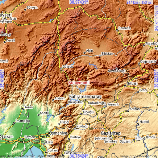
Below is the Elevation map of Süleymanlı, which displays elevation range with different colors. Scale of the first map is from 679 to 2005 m (2228 to 6578 ft) with average elevation of 1226.2 meters (=4023 ft) [note 1]
These maps also provides idea of topography and contour of this city, they are displayed at different zoom levels. More info about maps, scale and edge coordinates you can find below images.

| \ | Map #1 | Topo.Map |
| Scale [m] | 679..2005 m | × |
| Scale [ft] | 2228..6578 ft | × |
| Average | 1226.2 m = 4023 ft | × |
| Width | 7.71 km = 4.8 mi | 246.8 km = 153.4 mi |
| Height | 7.71 km = 4.8 mi | 246.8 km = 153.4 mi |
| ↑Max Latitude | 37.907321° | 38.97431° |
| Latitude at center | 37.87264° | 37.87264° |
| ↓Min Latitude | 37.837942° | 36.75424° |
| ← Min Longitude | 36.773195° | 35.41089° |
| Longitude center | 36.81714° | 36.81714° |
| →Max Longitude | 36.861085° | 38.22339° |
Nearby cities:
Cities around Süleymanlı sort by population:
• Kahramanmaraş elevation 564 m
33.4 km,  163°
163°
• Elbistan 1139 m
49.9 km,  42°
42°
• Afşin 1222 m
42.6 km,  11°
11°
• Göksun 1344 m
32.5 km,  300°
300°
• Çağlayancerit 1086 m
43.6 km,  108°
108°
• Andırın 1047 m
52.2 km,  231°
231°
• Celeyke 1285 m
38.6 km,  57°
57°
• Türkoğlu 561 m
54.1 km,  177°
177°
• Çokak 1240 m
45.5 km,  250°
250°
• Yenicekale 1012 m
34.5 km,  208°
208°
• Ağabeyli 1018 m
30.5 km,  120°
120°
• Çardak 1399 m
24.4 km,  1°
1°
Multilingual:
 En español:
Süleymanlı elevación 1137 m.
 En France:
Süleymanlı élévation 1137 m.
 Auf Deutsch:
Süleymanlı höhe über dem Meeresspiegel ist 1137 m.

Sources and notes:
- [note 1] Map square and city borders are not equal. Map elevation data is calculated only from area inside that square.
- [src 1] Elevation data from geonames database provided with same terms of usage.
- [src 2] The elevation map of Süleymanlı is generated using elevation data from NASA's 3 arcsec (90m) resolution SRTM data.
- [src 3] Base (background) map © OpenStreetMap contributors tiles are generated by Geofabrik and OpenTopoMap.
Copyright & License:
This Süleymanlı Elevation Map is licensed under CC BY-SA. You may reuse any part from this page, if you give a proper credit by linking to this URL:
 More info on terms of use page.