Çağlayancerit elevation
Çağlayancerit (Kahramanmaraş), Turkey elevation is 1086 meters and Çağlayancerit elevation in feet is 3563 ft above sea level [src 1]. Çağlayancerit is a seat of a second-order administrative division (feature code) with elevation that is 363 meters (1191 ft) bigger than average city elevation in Turkey.
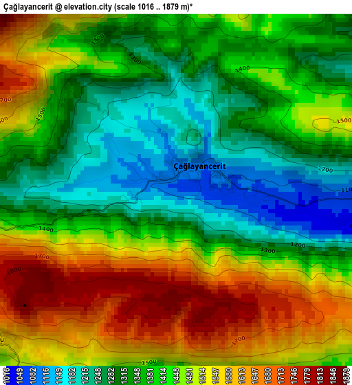
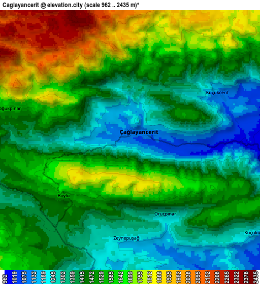
Below is the Elevation map of Çağlayancerit, which displays elevation range with different colors. Scale of the first map is from 1016 to 1879 m (3333 to 6165 ft) with average elevation of 1417.5 meters (=4651 ft) [note 1]
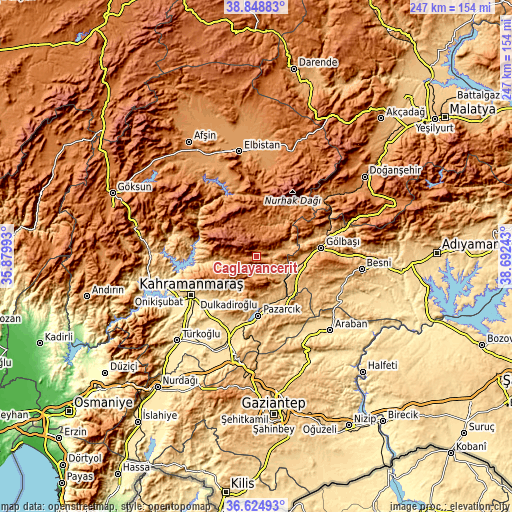
These maps also provides idea of topography and contour of this city, they are displayed at different zoom levels. More info about maps, scale and edge coordinates you can find below images.
| \ | Map #1 | Map #2 | Topo.Map |
| Scale [m] | 1016..1879 m | 962..2435 m | × |
| Scale [ft] | 3333..6165 ft | 3156..7989 ft | × |
| Average | 1417.5 m = 4651 ft | 1506.6 m = 4943 ft | × |
| Width | 7.73 km = 4.8 mi | 15.46 km = 9.6 mi | 247.3 km = 153.7 mi |
| Height | 7.73 km = 4.8 mi | 15.46 km = 9.6 mi | 247.3 km = 153.7 mi |
| ↑Max Latitude | 37.779971° | 37.814696° | 38.84883° |
| Latitude at center | 37.74523° | 37.74523° | 37.74523° |
| ↓Min Latitude | 37.710473° | 37.675699° | 36.62493° |
| ← Min Longitude | 37.242235° | 37.198289° | 35.87993° |
| Longitude center | 37.28618° | 37.28618° | 37.28618° |
| →Max Longitude | 37.330125° | 37.374071° | 38.69243° |
Nearby cities:
Cities around Çağlayancerit sort by population:
• Kahramanmaraş elevation 564 m
36.4 km,  240°
240°
• Gölbaşı 898 m
31.1 km,  82°
82°
• Pazarcık 787 m
28.8 km,  177°
177°
• Araban 527 m
50.1 km,  134°
134°
• Nurhak 1384 m
27.8 km,  29°
29°
• Celeyke 1285 m
36 km,  346°
346°
• Süleymanlı 1137 m
43.6 km,  288°
288°
• Harmanlı 1141 m
41.6 km, 75°
• Narlı 588 m
41.5 km,  198°
198°
• Suvarlı 979 m
38.1 km, 127°
• Belören 990 m
28.5 km,  114°
114°
• Ağabeyli 1018 m
15 km,  265°
265°
Multilingual:
 En español:
Çağlayancerit elevación 1086 m.
 En France:
Çağlayancerit élévation 1086 m.
 Auf Deutsch:
Çağlayancerit höhe über dem Meeresspiegel ist 1086 m.

Sources and notes:
- [note 1] Map square and city borders are not equal. Map elevation data is calculated only from area inside that square.
- [src 1] Elevation data from geonames database provided with same terms of usage.
- [src 2] The elevation map of Çağlayancerit is generated using elevation data from NASA's 3 arcsec (90m) resolution SRTM data.
- [src 3] Base (background) map © OpenStreetMap contributors tiles are generated by Geofabrik and OpenTopoMap.
Copyright & License:
This Çağlayancerit Elevation Map is licensed under CC BY-SA. You may reuse any part from this page, if you give a proper credit by linking to this URL:
 More info on terms of use page.