Beylikova elevation
Beylikova (Eskişehir), Turkey elevation is 768 meters and Beylikova elevation in feet is 2520 ft above sea level [src 1]. Beylikova is a seat of a second-order administrative division (feature code) with elevation that is 45 meters (148 ft) bigger than average city elevation in Turkey.
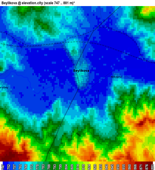
Below is the Elevation map of Beylikova, which displays elevation range with different colors. Scale of the first map is from 747 to 881 m (2451 to 2890 ft) with average elevation of 778.6 meters (=2554 ft) [note 1]
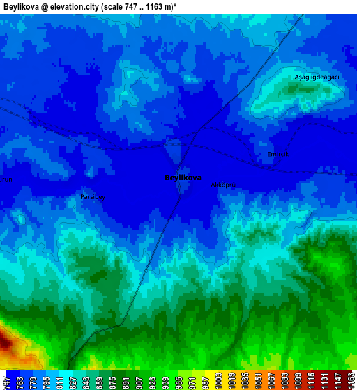
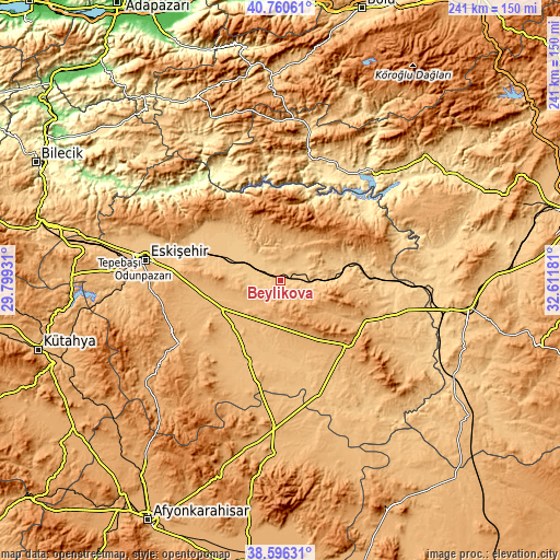
These maps also provides idea of topography and contour of this city, they are displayed at different zoom levels. More info about maps, scale and edge coordinates you can find below images.
| \ | Map #1 | Map #2 | Topo.Map |
| Scale [m] | 747..881 m | 747..1163 m | × |
| Scale [ft] | 2451..2890 ft | 2451..3816 ft | × |
| Average | 778.6 m = 2554 ft | 813.9 m = 2670 ft | × |
| Width | 7.52 km = 4.7 mi | 15.04 km = 9.3 mi | 240.6 km = 149.5 mi |
| Height | 7.52 km = 4.7 mi | 15.04 km = 9.3 mi | 240.6 km = 149.5 mi |
| ↑Max Latitude | 39.72075° | 39.754543° | 40.76061° |
| Latitude at center | 39.68694° | 39.68694° | 39.68694° |
| ↓Min Latitude | 39.653114° | 39.619271° | 38.59631° |
| ← Min Longitude | 31.161615° | 31.117669° | 29.79931° |
| Longitude center | 31.20556° | 31.20556° | 31.20556° |
| →Max Longitude | 31.249505° | 31.293451° | 32.61181° |
Nearby cities:
Cities around Beylikova sort by population:
• Nallıhan elevation 630 m
56.9 km,  12°
12°
• Sivrihisar 1090 m
38.5 km,  133°
133°
• Çifteler 876 m
36.7 km,  202°
202°
• Alpu 765 m
22.8 km,  293°
293°
• Seyitgazi 983 m
51.4 km,  238°
238°
• Bozan 806 m
14.3 km,  321°
321°
• Sevinç 787 m
45.4 km,  283°
283°
• Odunpazarı 799 m
58 km, 278°
• Umraniye 905 m
57 km,  177°
177°
• Mihalıçcık 1322 m
31.8 km,  51°
51°
• Mahmudiye 887 m
28.1 km,  221°
221°
• Kaymaz 978 m
19.1 km,  186°
186°
Multilingual:
 En español:
Beylikova elevación 768 m.
 En France:
Beylikova élévation 768 m.
 Auf Deutsch:
Beylikova höhe über dem Meeresspiegel ist 768 m.

Sources and notes:
- [note 1] Map square and city borders are not equal. Map elevation data is calculated only from area inside that square.
- [src 1] Elevation data from geonames database provided with same terms of usage.
- [src 2] The elevation map of Beylikova is generated using elevation data from NASA's 3 arcsec (90m) resolution SRTM data.
- [src 3] Base (background) map © OpenStreetMap contributors tiles are generated by Geofabrik and OpenTopoMap.
Copyright & License:
This Beylikova Elevation Map is licensed under CC BY-SA. You may reuse any part from this page, if you give a proper credit by linking to this URL:
 More info on terms of use page.