Sivrihisar elevation
Sivrihisar (Eskişehir), Turkey elevation is 1090 meters and Sivrihisar elevation in feet is 3576 ft above sea level [src 1]. Sivrihisar is a seat of a second-order administrative division (feature code) with elevation that is 367 meters (1204 ft) bigger than average city elevation in Turkey.
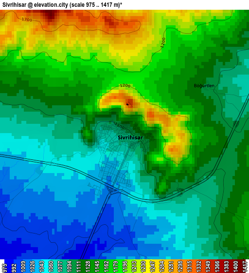
Below is the Elevation map of Sivrihisar, which displays elevation range with different colors. Scale of the first map is from 975 to 1417 m (3199 to 4649 ft) with average elevation of 1117.9 meters (=3668 ft) [note 1]
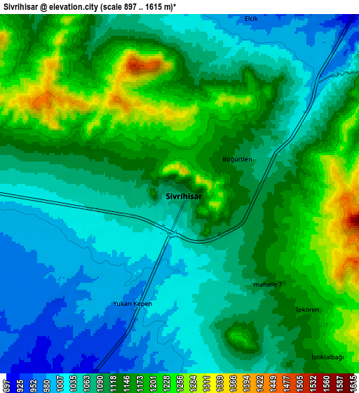
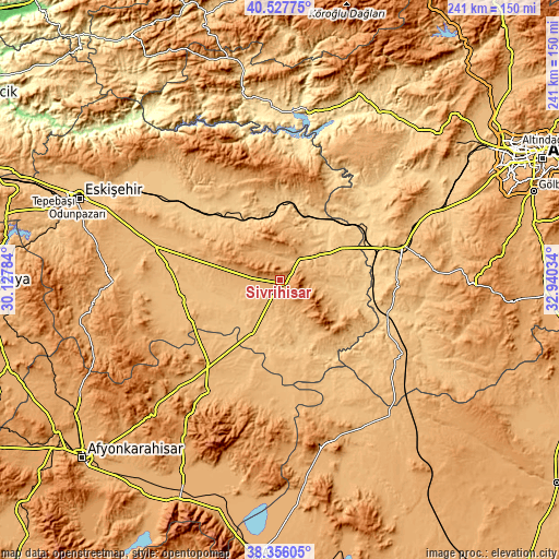
These maps also provides idea of topography and contour of this city, they are displayed at different zoom levels. More info about maps, scale and edge coordinates you can find below images.
| \ | Map #1 | Map #2 | Topo.Map |
| Scale [m] | 975..1417 m | 897..1615 m | × |
| Scale [ft] | 3199..4649 ft | 2943..5299 ft | × |
| Average | 1117.9 m = 3668 ft | 1108.9 m = 3638 ft | × |
| Width | 7.55 km = 4.7 mi | 15.09 km = 9.4 mi | 241.5 km = 150.1 mi |
| Height | 7.55 km = 4.7 mi | 15.09 km = 9.4 mi | 241.5 km = 150.1 mi |
| ↑Max Latitude | 39.484295° | 39.518204° | 40.52775° |
| Latitude at center | 39.45037° | 39.45037° | 39.45037° |
| ↓Min Latitude | 39.416428° | 39.38247° | 38.35605° |
| ← Min Longitude | 31.490145° | 31.446199° | 30.12784° |
| Longitude center | 31.53409° | 31.53409° | 31.53409° |
| →Max Longitude | 31.578035° | 31.621981° | 32.94034° |
Nearby cities:
Cities around Sivrihisar sort by population:
• Polatlı elevation 855 m
54 km,  74°
74°
• Çifteler 876 m
43.2 km,  260°
260°
• Beylikova 768 m
38.5 km,  313°
313°
• Bozan 806 m
52.7 km,  315°
315°
• Yenimehmetli 932 m
54.6 km,  93°
93°
• Davulga 1032 m
54.2 km,  194°
194°
• Çeltik 852 m
52.3 km,  154°
154°
• Mahmudiye 887 m
47.2 km,  276°
276°
• Mihalıçcık 1322 m
46.3 km,  355°
355°
• Umraniye 905 m
40 km,  220°
220°
• Kaymaz 978 m
31.3 km, 283°
• Günyüzü 892 m
24.8 km,  107°
107°
Multilingual:
 En español:
Sivrihisar elevación 1090 m.
 En France:
Sivrihisar élévation 1090 m.
 Auf Deutsch:
Sivrihisar höhe über dem Meeresspiegel ist 1090 m.

Sources and notes:
- [note 1] Map square and city borders are not equal. Map elevation data is calculated only from area inside that square.
- [src 1] Elevation data from geonames database provided with same terms of usage.
- [src 2] The elevation map of Sivrihisar is generated using elevation data from NASA's 3 arcsec (90m) resolution SRTM data.
- [src 3] Base (background) map © OpenStreetMap contributors tiles are generated by Geofabrik and OpenTopoMap.
Copyright & License:
This Sivrihisar Elevation Map is licensed under CC BY-SA. You may reuse any part from this page, if you give a proper credit by linking to this URL:
 More info on terms of use page.