Odunpazarı elevation
Odunpazarı (Eskişehir), Turkey elevation is 799 meters and Odunpazarı elevation in feet is 2621 ft above sea level [src 1]. Odunpazarı is a seat of a second-order administrative division (feature code) with elevation that is 76 meters (249 ft) bigger than average city elevation in Turkey.
Below is the Elevation map of Odunpazarı, which displays elevation range with different colors. Scale of the first map is from 781 to 948 m (2562 to 3110 ft) with average elevation of 823.8 meters (=2703 ft) [note 1]
These maps also provides idea of topography and contour of this city, they are displayed at different zoom levels. More info about maps, scale and edge coordinates you can find below images.
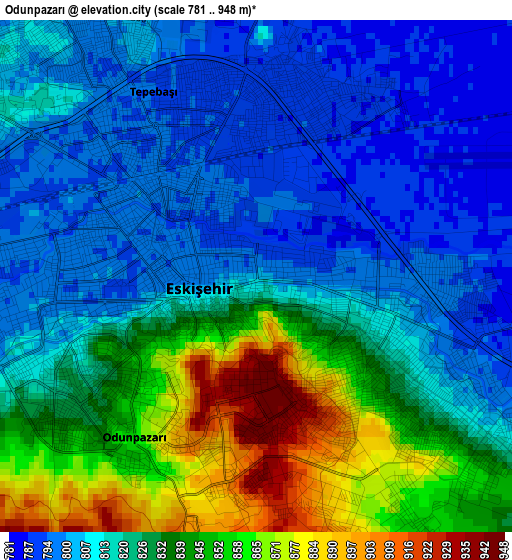
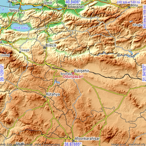
| \ | Map #1 | Topo.Map |
| Scale [m] | 781..948 m | × |
| Scale [ft] | 2562..3110 ft | × |
| Average | 823.8 m = 2703 ft | × |
| Width | 7.51 km = 4.7 mi | 240.4 km = 149.4 mi |
| Height | 7.51 km = 4.7 mi | 240.4 km = 149.4 mi |
| ↑Max Latitude | 39.80198° | 40.8406° |
| Latitude at center | 39.76821° | 39.76821° |
| ↓Min Latitude | 39.734424° | 38.67885° |
| ← Min Longitude | 30.491435° | 29.12913° |
| Longitude center | 30.53538° | 30.53538° |
| →Max Longitude | 30.579325° | 31.94163° |
Nearby cities:
Cities around Odunpazarı sort by population:
• Eskişehir elevation 794 m
1.6 km,  306°
306°
• Mihalgazi 211 m
28.9 km,  7°
7°
• Alpu 765 m
36.3 km,  89°
89°
• Seyitgazi 983 m
38.5 km,  159°
159°
• İnhisar 227 m
33.8 km,  337°
337°
• Sevinç 787 m
13.2 km,  84°
84°
• Söğüt 690 m
40.5 km, 312°
• Sabuncu 963 m
37.6 km,  232°
232°
• İnönü 844 m
33.7 km,  278°
278°
• Sarıcakaya 222 m
30.9 km, 14°
• Hekimdağ 1249 m
15.9 km, 9°
• Tepebaşı 787 m
4.8 km,  349°
349°
Multilingual:
 En español:
Odunpazarı elevación 799 m.
 En France:
Odunpazarı élévation 799 m.
 Auf Deutsch:
Odunpazarı höhe über dem Meeresspiegel ist 799 m.

Sources and notes:
- [note 1] Map square and city borders are not equal. Map elevation data is calculated only from area inside that square.
- [src 1] Elevation data from geonames database provided with same terms of usage.
- [src 2] The elevation map of Odunpazarı is generated using elevation data from NASA's 3 arcsec (90m) resolution SRTM data.
- [src 3] Base (background) map © OpenStreetMap contributors tiles are generated by Geofabrik and OpenTopoMap.
Copyright & License:
This Odunpazarı Elevation Map is licensed under CC BY-SA. You may reuse any part from this page, if you give a proper credit by linking to this URL:
 More info on terms of use page.